Friday, March 4, 2016

Mountaineering Trip to the PNW Part 2: Planning

With gear purchased and testing in progress, the next step was to learn as much as possible about the mountains we were planning to climb.  There is nothing I hate more than going into a trip unprepared.  It's one thing if you're on a short summer hike on the east coast, but a winter expedition to volcanoes in the Cascades is a big deal.  Initially, our plan was to try to hit two state high points: Mt. Hood (11,250) and Mt. Rainier (14,409).

It was in this planning phase that I discovered that my ascent up Borah Peak in Idaho (12,667) from May 2015 was in fact a bust.  Socked in with clouds, I had made it to a false peak just above Chicken-out Ridge, nearly a mile and 1000 vertical feet from the actual summit.  This began clawing away at my insides, and I needed to get back to that mountain and give it another shot.  I asked Noah his thoughts on it, and he said "sure, put it on the list!"  I may have left out the fact that it was 700 miles away from Mt. Hood.

Borah
So Hood, Rainier, and Borah.  I was almost more focused on Borah at this point, but Noah was focused on Hood, so I figured we would eventually get all the information we needed with frequent "war meetings" as he puts it.  After looking into Rainier for a few nights, I had a gut feeling that was bad about it, so I told Noah that I thought it was outside of our range to pull it off, and I just didn't feel right about it. I felt good about Hood and Borah, so we continued our research on them.

Borah has a simple way up, and that is to follow the trail from Birch Springs Road in Custer Co., then follow Chicken-out ridge to the summit.  My memory of the route from 2015 is still quite vivid, and looking at past pictures and route maps, I felt comfortable leading a climb up there, so long as we both had appropriate gear.

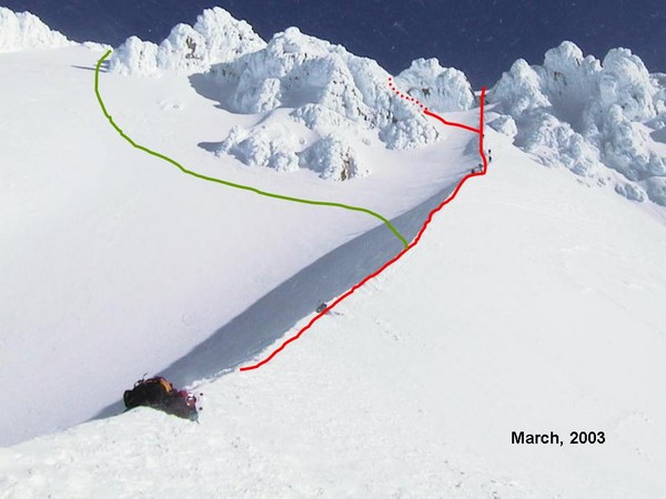
Hood was more complicated since it was a new target for both of us.  South side routes were by far the most common, but near the top of Hood is where several routes diverge, and have a vast range of technical difficulties.  The two common routes are the Pearly Gates and the Old Chute.  The Old Chute cuts off to the left and avoids a big hazard called the bergschrund, just above the Hogsback, which we thought to be a good idea since neither of us is trained with rope skills and crevasse rescue.  Best to just avoid that altogether and climb to the left of it.  In either case, we knew we were in for a climb that approaches 45° slope (100% grade) while going through the chutes.

Old Chute (green) and Pearly Gates (red) from the Hogsback.
Courtesy cascadeclimbers.com
I sought advice online for some other climbs that we could do in the area in case of bad weather during the week I was planning to spend out there.  Someone suggested Mt. Saint Helens via Worm Flows, so I looked into it.  At 8,366', it was considerably lower than the other objectives, but still with an ascent over 5000 feet involved.  That would be a good starter for me, considering I would need to get acclimated to higher elevation for a climb of Mt. Hood.

Mt. Saint Helens, courtesy Noah Pappano
At this point, we agreed on Mt. Saint Helens, Mt. Hood, and Borah Peak for our big climbs on the trip.  The main focus was Hood, though I was irritated by my false summit attempt on Borah, it became the primary objective for me.  It is strange how planning a trip like this becomes more than a logistic problem, and almost an emotional one.  Some mountains speak to you, and they lure you in.

I managed to get some time off from work, and I got it to match up with my weekends, allowing me 9 consecutive days!  The plan was that I would fly to Portland, OR and Noah would drive up from Arizona starting a few days prior.  From there the climbing would begin (assuming good weather).

Noah decided he wanted to rent mountaineering gear from one of the shops in Portland to save a bit on money.  The reason I bought outright is because I see myself doing big climbs like this in the future, though I'm not sure where Noah stands on that spectrum.  (Perhaps opinions have changed after the trip...)  I would rent a helmet since I don't own one, and snowshoes because I couldn't figure out how to pack them inside the bag for the flight.

In the week before my flight west, I began checking the mountain weather and avalanche sites, and I began to see a big problem, and that was a good 3 or 4 days of heavy snow in the PNW.  As our research had taught us, avalanche danger is high during storms as well as the day or so after the storm.  With limited to no avalanche experience, we wanted to minimize that danger as much as we could.  The best option, it seemed, was to go to Borah first, since weather was fair over Idaho during the storm over the Cascades.

The way the weather was shaping up, it looked like the whole plan was going to be reversed: Borah, Hood, then St. Helens.  Not a horrible plan, but the elevations were not in my favor, coming from a mere 200 feet above sea level.  I wasn't terribly concerned for Noah, since he was coming from 7000 feet in Flagstaff.  Thankfully, the temperatures weren't quite what I'd call frigid, though Idaho was noticeably cooler than the west coast, where temps were hovering around the 40s - 50s.

A trip report of Borah Peak will be in Part 3.

Wednesday, March 2, 2016

Mountaineering Trip to the PNW, Part 1: The Backstory

As someone who has gone longer and bigger with my hikes over the past few years, a mountaineering expedition still loomed above as an intangible concept.  Well, I suppose that all changed over this winter when in September my buddy Noah from Baxter SP trail crew told me to come climb Mount Hood in February.  I was reluctant as it seemed like a logistic nightmare, especially with a full time job acquired after finishing my 2015 road trip.  I agreed that I would climb Mt. Hood at some point in the future, but with no timestamp to speak of.

Nearly a month later, after tossing the idea around for awhile, I decided I was going to do it. Logistics could be figured out, but Mount Hood was something I wanted in my life, and what better a time than in February, when cabin fever is going strong? On October 16, 2015, I messaged Noah:

"I've had enough of this life.  I've decided I am coming out to Oregon as per your request.  Which week in February would you like?"

It was a change in mentality for me, as I rejected the idea that it was something outside my reach.  I had climbed over 12k before, and I would have time and funds to buy and test out additional climbing gear over the winter.  They say the white mountains are a great place to train for much larger climbs, at least in regards to the ferocious weather.

Mt. Hood
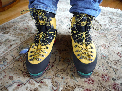
Over the next month or so, I got mountaineering boots and crampons to accompany my ice axe and leash I had gotten last year.  I went with La Sportiva Nepal Evos, which have many good reviews amongst climbers, and because of the stiff sole, can accommodate step-in crampons and make crampon techniques less tiring during a climb.  As for crampons, I went with Black Diamond, a reputable brand in this segment.  I had a good idea of Black Diamond's quality from my ice axe so far, and I felt sound in my decision to stay with the brand.

La Sportiva Nepal Evo boots!
Black Diamond Sabertooth Pro crampons
It was awhile before I was able to try out any of this gear because the winter began so mildly and with hardly any snow.  Finally, in December I was able to test out gear in western Maine.  Baldpate Mountain and Old Speck were the first mountains to get the thorough test of my gear, and they performed beyond expectations.  The stiff boots are quite strange to walk in until you get used to them.  Over time, I've noticed that the ankle softens up a bit, which is more comfortable yet still provides the support needed for climbing steep slopes.

Over the winter hiking season prior to leaving for Oregon, I got in about 40 miles of testing and training in with my boots and crampons.  They make SUCH a difference compared to my Merrell Moabs, which I have hiked in almost exclusively so far, even in the winter season.  Normally, I am not a fan of boots for hiking, however with these boots as part of my gear, winter climbs are much more enjoyable, and they take my capabilities up a notch with the crampons.

Friday, February 19, 2016

Mountaineering Trip to the PNW Part 3: BORAH

Let me preface this trip report by saying that driving 700 miles in one day before a major mountain climb is not the best idea.  Especially when the gear shop you're renting from opens at 10am.  So despite a late start, we headed to the east, following the stunning Columbia River gorge on I-84 for many miles.  There was no snow, and plenty of rain (welcome to the PNW!), though things cleared up a bit as we moved past the Cascades.

As Noah accuses me of saying on multiple occasions, I thought eastern Oregon looked very much like New Mexico.  It is much drier here than on the west side of the mountains, and because of this dryness, you get a lot of the same flora that you see in NM.  Not to mention the landscape somehow matches up eerily well.

Once in Idaho, we had to cross the southern tip of the Sawtooth Mountains, in a strange late evening light that was augmented with a snow squall and diffused moonlight trying to peek through the clouds.  Following US-20 eastward is straight and straight for miles, nearly putting me to sleep after so much driving already.  We dipped through the northern section of Craters of the Moon National Monument, and the snow clouds had cleared, leaving a bright moon to light up the surrounding mountains.  It was perhaps one of the more beautiful nights I've driven through. From Arco, ID, it was 40 miles north to the beloved Borah trailhead.  Driving between the mountain ranges like this was stunning, and we kept waiting for Borah to be around the next bend in the valley, though at night, everything tends to blend together.  We saw a worrying amount of deer and elk on the roads, which was not fun in my tired condition.

We had been concerned about the approach road, Birch Springs, as it's a forest road and it was impossible to find out if it was plowed or not.  Calling the Forest Service provided us with a conditions report, saying there were many feet of snow drifts, and a 2WD van would not make it up.  We were expecting to add 3 miles each way to our expedition, with 1000 feet of gain.  Pulling into the road, we saw it was plowed with hardly any snow on the ground, just a few patches of ice.  We stopped at the RV turnout just shy of the summer parking area.  Let's just say that dinner was hastily made and we wanted sleep badly.  We had gotten in at about 10pm MST.

Borah, morning of 2.19.16
Mountains to the west
The morning was cold and uncomfortable.  We made breakfast and organized our gear, which I would have preferred to do the night before.  We got a late start by alpine standards...I mean the sun was already up behind the mountain and lighting up the Sawteeth to the west.


We hiked on snowshoes to the summer parking area and found already a problem with Noah's boots.  He was wearing the same model of boots I had, but his feet were already painfully numb.  I knew if we didn't warm them up now, there was no way of continuing.  He had footwarmers, so I was confused why his feet were so cold.  We take off the boots and I discover summer hiking socks.  Perhaps one of the most important parts of our gear, we had failed to discuss beforehand.  Assumptions are be deadly...however, luckily I was prepared, so I had him take my spare winter socks from my pack and put those on over the other socks.  He added extra warmers to the boots and he laced back up.

Not 10 minutes later, Noah told me his feet weren't getting better.  I thought, there is no way we can climb today - what else could possibly be making his feet cold with winter insulated boots, plenty of socks, and two sets of warmers?  Then I realized maybe his feet were in too tight, cutting of blood-flow to his toes.  We stopped and I told him I'd warm his feet my blowing on them until he was comfortable and the inner socks had to come off.  This, if nothing else, was my lesson for this climb.  I learned more about foot warmth and what you need to be prepared if you or your climbing partner gets very cold feet.  Not enough insulation and you are cold, too much and you cut off circulation.  After what felt like a long time, his feet were getting better, and I was feeling a little dizzy from all the blowing, but I had him strip the inner socks and keep the thick socks he was borrowing.  I knew the warmth from me wouldn't last so I told him once the snowshoes were back on, we had to get moving immediately.  After a little bit of climbing, he reported an improvement.  Frostbite averted!


The climbing was challenging here not because of slope, but because there are zero markings that are visible with 3-4 feet of snow on the ground.  I was going purely based on my memory of where the trail goes and some possible human or animal tracks.  The snow was not all hard packed, so finding a route with no postholing was impossible.  We would break through every so often, which was irritating.  The leader would frequently switch off to keep us both relatively fresh.  As we followed the side of a drainage gully, the snow was getting much deeper and not so solid.  I knew we had to cross the gully, then we would head up to the left with a right-hand slope.  Shortly after we crossed, I suggested we switch from snowshoes to crampons.  We left the shoes on the side of the trail to save weight.

This was Noah's first time wearing crampons in the field.  We had practiced putting them on at the gear shop, but I was there to help, since I had worm them throughout the winter in Maine.  Immediately the benefits were obvious.  With such a slope, we were squishing down less snow with the crampons than the shoes, and the going was much easier.  We brought out the axes at this point for safety and stability.

Right before the first top-out
We topped out at the first flat area, which I believe only took me 30 minutes when I climbed in May 2015.  This portion had taken 3 hours this time.  A considerable difference and not one to be ignored.  The going was slow and was going to be slow for the rest of the climb.  From this flat area, the trail hooks to the right and follows the ridge the the summit, so it should have been fairly simple.  However, in summer, it is clear that the trail has many short switchbacks that weave up the ridge.  Everything was buried this time.  We decided since we cutting through an enormous amount of snow, to ascend directly up the ridge.

Several problems arose because of this decision.  There are many dead and twisted trees lying on the ground in this forest, and those kept tripping us up, not to mention the actual direction we needed to go was hard to follow due to the rounded nature of the slope.  I was having altitude problems already, and we were still several thousand feet below the summit.

Me trying to act energized
We just decided to take it slow, take breaks when we needed, and switch who was breaking trail often.  I recall one place we took a break, at a nice log to sit and eat a snack.  I began leading again, pushing through snow that was at least up to my waist.  The crust on top was getting thicker, and required breaking with my thighs or hands first before I could proceed.  I was making progress, then I looked back and had only made it about 6 feet.  I was feeling dismal.  I did my best, but Noah ended up having to break the trail for much more of the time.  I was used to thick snow and slopes, but I was not used to the altitude.  I just get sleepy with altitude, not so much the sick symptoms that some people report.  That did not help my progress though, since taking a nap doesn't move you up the hill so fast.

With Noah leading, he got fairly far ahead of me, still in sight, but not all the time because of trees.  Slow and steady was my mantra.  Noah told me to breathe deeply with each breath, as that would help me get as much oxygen as I could.  I tried this, and found some improvement in my pace, though it was still slow as death.  And it took all my concentration to do this.

I remember at one point I was leading again, and I suggested we head to the right because I was able to see some mountains off that way.  I wanted to see them, primarily because that was about my only motivation to continue at that point.  The sun had come out and was lighting up the snow so bright.  The wind had also picked up as we were higher up on the ridge, approaching the tree line.  The snow had gotten harder, and I was able to make it for periods of time walking on top of the snow.

As we ascended, a view of Dickey Peak to the north materialized, and it was then that Noah decided that was a place he wanted to be.  A strong resonance was found between him and the mountain.  Perhaps we will add that to another climbing trip in the future...

Dickey Peak to the north

One of the last trees we saw, and Dickey Peak
It was around 7.5 hours in to the climb when we finally broke tree line.  I remembered from my previous climb, that there was still a fair climb above tree line, and then we would top out at the edge of the western basin of Borah.  Noah was leading once again, ice axe in hand, looking like a mountain man once again!

Looking south to Mt. Idaho
A view of Borah's peak appeared as I came to the rim.  It was truly an experience being there once again.  I ate here; we took a breather.  I had to have a reality check.  With 8.5 hours used up to make it 2.5 miles, was there a chance we could make the summit before dark?  I didn't want to be above tree line in the dark, with high exposure.  The time was 4:40 MST and that certainly didn't leave very much time to get up another 2000 vertical feet and back down in time for dusk.  We continued a little bit further along the rim with the basin to our left to an estimated 10,600'.  We had the talk.  Did we want to turn back?  What did success mean on this mountain?


Noah mentioned than his nose and feet were getting cold.  I had the talk with myself, about whether to continue.  I saw the beautiful peak in front of me.  Its alternate name is actually Beauty Peak, according to the old USGS maps.  We saw some darker clouds rolling in from the north.  It was the mountain's way of saying that we weren't going to summit today.  We were at a high point along the basin rim, and decided it would be there that we turn around.  I wanted to thank the mountain for allowing us to get as far as we did.  I flew 3500 miles and drove another 700 to thank a piece of rock and say that I'd be back again.  If mountaineering is ever emotional, this is the place where it is.  Where you turn back.  You are balancing your drive and will power to make it to the summit, colloquially known as summit fever, and your own survival and reasoning.  There is not much else that powers climbed to climb aside from will power and the fact that some mountains make us feel at home, and to have to overcome that drive is certainly a challenge.  Especially the second time.

Farewell to Borah...at least this time
We snapped some pictures, and I quickly brought out a balaclava for Noah's nose, since I was warm enough with my winter-weight hiking buff.  We removed the crampons for most of the descent, which took Noah some getting used to since it was still his first time using them.  We moved quickly down to the tree line, where things didn't get any easier.  The blowing snow had filled in most of our tracks, so we still had to bust through a few feet of snow on the descent, as well as watch for the trees and punji sticks.  There was a fair bit of falling over.

The day was dwindling as we made our way back down, knowing that we were on our way to safety instead of perhaps being blown down into a chasm thousands of feet deep.  Back at the lowest flat area on the trail, we put on the headlamps as the light was nearly gone.  The moon had just risen above the mountain behind us, and it was pink!  We soon found ourselves back at the snowshoe cache, and putting those on was a relief since our trail in the lower half of the trail was already broken.  The going was much easier, despite being exhausted.  With hydration and some cookies taken care of, we were on the move once again.  Looking behind us, the moon was lighting the clouds up from the top, and showing how rapidly they were moving.  We were glad not to be in the high winds anymore.

We got the summer parking area and continued down the road to our parking spot, ready to either eat half our week's food supply, or to just topple into bed immediately.  We arrived at the van 12 hours after departure in the morning.

Noah did the whole bed thing immediately, however I was craving some food, so I ate something and swore a fair bit while doing dishes in the sub-freezing temps outside.  I slept soundly and for a long time.

Success for me on Borah this time meant getting to be there for a second time...a place that I thought I would never see again.  Success meant getting to see the peak from the basin rim, even if that was 2000 feet below summit elevation, and it meant getting both of us down to the van without frostbite or other injuries.  At this point, I know I will come back to Borah...I don't care if it's my white whale, but I will keep trying as hard as the mountain makes me.  It is truly a beautiful place to be.  I didn't mention it above so much, but looking around up on this mountain provides you with some of the best endless mountain views I've seen.  It is so rugged, yet calm and gentle.  Then you remember that Borah rose 7 feet in an earthquake in 1983, and you realize that it's truly a rugged and wild place.  Just the kind of place I want to be in.

Google Earth Track/Profile
Hike Details
Miles hiked: 5.0
Time elapsed: 12 hours
Total ascent: 3420'

Wednesday, January 6, 2016

Old Speck: A winter sunrise

Sometimes crazy good things come of not so great things.  I consider this such an instance.  The original plan was simple: a nice winter hike of Old Speck in an attempt to summit where in 2014 Eliot and I had turned around after three miles in hopes of survival.  Old Speck has been a special mountain to both of us since we both first climbed in summer of 2011.  I have been back a few more times than he, but I think we can agree it holds a special place in both of us.

The proverbial monkey wrench in the situation is of course being asked to attend work the day that this adventure was planned.  I agreed to an afternoon of work in hopes that I could squeeze in a small hike in the morning in lieu of Old Speck.  As I drove home on Tuesday evening, my frustration of the day's plan being squashed brought me to the conclusion that I was still going to get my summit in…just much earlier.  I would do a sunrise summit of Old Speck.  As any guy with a pal would do, I called Eliot up to see the interest level.  Within seconds, there was agreement, though I had to emphasize my choice of mountain to him.

With Baldpate under our belts from last week, we assumed a similar ascent time of 6 hours.  Sunrise was at 7:20am.  That meant starting the hike at 1:20am.  That meant driving out at 10:20pm that night.  That meant hiking a 4000 footer on no sleep.  My insanity was confirmed.  But sometimes you just need to take life my the throat and climb that goddamn mountain for sunrise.

We met in Belfast in case I would need to go directly from the hike to work.  In order to get to work by 1pm, we'd have to be off the mountain by 10am at the latest.  That is cutting it close, but I knew we could descend faster than we could ascend, so I assumed we could pull it off.  I had Eliot drive because he was raging with energy.

Three goofy hours later, we arrived at Grafton Notch once again.  We began getting our stuff together, and it was then I realized a crucial error on my part.  I had left my water bottles filled with boiling water at home.  And my gaiters.  Eliot had a stove to melt snow, thankfully, though soon that was a dead end because we had no pot.  In such a situation, it is hard to balance reason with my severe case of summit fever.  Eliot had 2.5 liters of water, which in the end we decided would be enough for both of us to make it to the top.  We finished with gearing up despite wasting nearly an hour trying to figure out how to deal with the water problem.  I was expecting that we would not get sunrise, but I was okay with that.

Eliot climbing the lower part of the trail
We began the climb with crampons on from the start, and the ease that they provide it staggering.  No slipping whatsoever, and all the energy goes into up, up, and up!  It was not long before we made it to the Eyebrow Trail junction, roughly 1.1 miles in.  The ledges appeared, and we turned off headlamps to look at the stars.  If you ever hike on a clear night, just turn off the light for a bit and look up.  You won't regret it.  We have an incredible sky.

It was around now that I began to notice the effects of the canned coffee Eliot had downed at the start.  There was a raging animal of speed and precision ahead of me instead of an Eliot that I was coercing into every next step, which was the situation on our previous -20°F winter attempt on Old Speck.  In any case, the energy between us was bubbling, as we wanted our sunrise quite badly.  We did some quick math at this trail junction to determine our ETA for the summit.  Assuming a relatively constant pace, we were going to be nearly two hours EARLY.  Which is a tricky problem because staying warm even at 16° means staying moving.

We pushed on with some speed because we didn't want to miss it in case the going got hard, but not 100% because of the aforementioned problem.  There were periods of mostly calm in the forest mixed with some worrying bouts of wind, warning us of what was to come later.

The spot we had reached in the winter of 2014 was still stuck firmly in our minds.  It is a clearing with one rock and a small tree.  We had bashed a semi-frozen water bottle on that very rock to break up our remaining half a liter of water and put some melted snow in it.  It was nearly evening on that day, and I had not be so afraid of frostbite in my life.  Ten seconds of exposed skin was enough to cause numbness and pain.  The thought of passing this spot was overwhelming as we climbed.

Crescent Moon over "the Nubble" (as coined by Nathan)
Like many places on this mountain, that very clearing (we call this the Nubble) appeared out of nowhere.  We had made it to our turn around spot.  It was 4:50am.  A crescent moon had risen in front of us with a planet just below it.  I felt alive; I felt like perhaps there was a connection to the universe, whether we call this spiritual or not.  There is no way I can accurately describe how it felt to arrive at this location.  It's not the summit, but it has such vivid memories of frigidness, pain, battling of decisions, and utter survival from winter of 2014.

We took a moment to take it all in, and realize that from here, we were pushing further than we had as a team before.  I had ascended to the summit in another winter trip up here, but to go with a climbing partner with whom there is a rich history makes it different; it makes it better.  I had Eliot lead the way from here to the top, as it is his honor to make his first winter ascent of the mountain.

There is a ledge that the trail passes on the left, and immediately after a lefthand switchback.  This had been completely snowed in when I summited in March 2014, and one of the my climbing partners for the day had sunken in to his chest, and we had to pull him out by packing the snow around him with snowshoes first.  On the descent, we slid down the slope instead of taking the switchback, which was truly fun with there are feet and feet of snow beneath you.  This spot is just below an exposed section, so we bundled up with extra layers.  (See, we've learned to do this before getting cold, as opposed to once we were already cold like in the past, and the payoff is immense.)

The time was 5:50am, and we made it to the summit of the mountain.  My seventh time standing here, and Eliot's second.  The summit tower also comes out of nowhere, and we were surprised at how close it seemed to the turn-around spot from 2014.  Could it have been possible to summit on that very cold day?  Perhaps conditions can make that much of a difference.

Tower in range...
We could hear the winds howling on top of the tower as we celebrated having completed our goal of summiting Old Speck in the winter, and not missing the sunrise.  It was still mostly dark, but with the slightest tinge of lighter blue on the southeastern horizon.  And of course the crescent moon.

We wanted to check out the tower, but first we applied some layers because of the ferocious winds we could hear.  Slowly, we made our way up the ladder, crampons on because all the ice.  Once above the trees, I couldn't hear a thing from Eliot.  He had gone first, with a ski mask, and opened the door to the platform on top.  I followed, and soon discovered I needed a ski mask.  I could hardly hold on, the winds were so strong.  The strongest I've experienced, I believe.  We did not stay long, though by shouting at whisper distance, I was able to say I'd like a few photos of each other.


(I borrowed Eliot's mask)

After coming to the ground, the issue now was how to stay warm for an hour and a half until the sun rose.  We debated going to check out Speck Pond, which was 1.4 miles along the back side of the mountain, but I didn't feel like potentially missing the sunrise, so I voted that we go past the summit on the Grafton Loop Trail just a little bit to keep ourselves moving.  No one had been here and the snow was soft and powdery.  After a bit, we turned back toward the summit, just now realizing the slope we had just descended was significant.  But it kept us warm.

We alternated jumping around, eating some snacks, and running in circles, and going up and down the tower, to stay warm, since the sky had grown a bit brighter to include some of the brightest reds I've ever seen in nature.


The snow bits falling off the tower looked like a meteor shower in my photos because the flash was on.  I found that gave the best results of the colorful sky and getting the snowy trees in the foreground.  I was also occasionally hit was some of these small bits of snow and ice.


I was in awe, not merely because it was filled with beautiful colors, but because I had finally outsmarted nature to summit a mountain without being socked in with clouds.  Being able to see so far from a mountain is special.  Everything felt special.  I had gone out of my way to do a crazy hike, and this was the payoff.

Moon and Planet

As it neared 7:20, we decided to get ready and climb the tower.  I went first this time, but I was too late.  I topped the trees and found the sun partially above the horizon.  I was dazzled with pinks and oranges and reds as I climbed.  All I could manage was shouting "we're late" to Eliot before I stopped mid-climb just to gaze and let the sun engulf me.  Eventually, I gained control and made it to the top of the tower.

Sun was early to the party
I looked in all directions toward mountains that I have been on, mountains that I would like to be on, and of course the first light hitting all of these peaks.  Mount Washington was initially one idea I had had for hiking that day, and to look over at it was stunning.  Between the gusts of wind that nearly knocked me over, I shouted to Eliot what the mountains were, and I think it was here that we decided that we will do Washington in the winter, perhaps next season when we are both around.  The air was so crisp and clear that it appeared so close.  We had seen a haze of the Presidentials in 2011 when we first climbed Old Speck, but it was clear to us now that it was indeed.

Mahoosuc Arm, Baldface, Carter Range, Presidentials (close to far)
We looked behind us to see the triangular mountain shadow.  The same very phenomenon that I had seen on Katahdin in October.  It was so cold that my camera battery could only manage a few photos before dying, then I'm place it on my skin to warm up for a few minutes.  Eliot got the shadow on his camera thankfully, though it will be forever stored in my memory.

Mountain shadow

We stayed long enough for the sun to hit eye level on the ground, and we could feel its warmth even on a cold day like today.  The color of light cast on the trees behind us as we faced the sun was unique.  Perhaps just that it was the first light of the day to light up these trees.  Eliot went up once more to the tower to get some photos.  I warned him to keep his gloves on this time, since I had to blow on them to get the feeling back last time because he left them out for too long.  Lessons, lessons.

Looking east
The sun

The morning sun gave a boost of energy that brought us down the mountain with considerable speed.  Even having climbed up all night, now in the light, we felt fresh.  (I think?)  We were doing well on water, likely because it's so hard to get enough in when it's cold out.  I had eaten some frozen croissants on the summit, which were nearly tasteless, but felt good to eat.  And some chocolate.  Always chocolate.

Beside the mountain being relentless in its descent, things went smoothly, and we kept looking back as the sun was rising over the mountain, making all the snow-covered trees glint like nothing ever does.  I tell you, that's my favorite part of winter hiking - it's the glint on the snow when the sun is out.

Baldpate Mountain, Table Rock toward the bottom
All the places we remembered on the way up flew by as we rocketed down.  I took off the crampons as I found it very challenging to walk without catching them on rocks under the not-so-deep snow.  I proceeded to slip and slide most of the way, which was killer fun.  We had the clock ticking, hence the motivation to go so quickly.


Looking up toward the summit from the ledges
Eliot at the ledges near the Eyebrow Trail jct.
We saw a few people on their way up as we neared the bottom, some more prepared than others it looked.  We hoped that they had some warmer layers for all body parts because it was quite unpleasant on exposed skin for us.

The Eyebrow
At 10:10am, we got to the base of the mountain, exactly 8 hours after we set off the night before.  The satisfaction of doing such a hike is just the best.  I got to see the best sunrise in my life, with my favorite climbing partner, on my favorite mountain.  All on a day that I was asked to work.  The celebration continued in the car as we removed the gear and began the drive east.  The ETA on the GPS was giving us mere minutes to spare before 1pm, my scheduled time to work.

For some reason, Eliot was still raging and awake, so I let him drive back.  I however, despite normally being the one with excess energy, did not last very long in the conscious world.  I slept on and off during the drive.

I arrived at work with 1 minute to spare, which I used to get out of climbing wear and into EBS wear.  I'll be honest, I was not the most enthusiastic that afternoon.  The simplest tasks were a mental challenge, but I declare it all worth the trip.  As Eliot made me aware, I had picked a task that used every last minute of my free time that day, and that is something I am proud of.  I promptly fell asleep after making it home that evening.  Yes, 35 hours is a long time to be awake, even with some breaks while your pal drives you to work.  No, I would not have rather done anything else.  WIth this hike, I officially declare the 2016 hiking season here!

Hike Details
Miles hiked: 7.8 (including going passed summit a bit)
Time elapsed: 8 hours
Total ascent: 3000'
(Old Speck Trail both ways)