Thursday, May 29, 2025

2025 Road Trip: Part 8 (Carlsbad Caverns)

Carlsbad Caverns, New Mexico

Day 8
5.29.25

I woke first on this morning to natural light filtering into our tent window, and my thoughts quickly went to the fact that today, I would finally get a chance to visit Carlsbad Caverns! Also, we would be crossing into Mountain Time at the TX-NM border, so technically we'd get a 25-hour day.

The sky was a perfect blue, and the weather was nice, and I went to the car to get breakfast going, however it wasn't long before I was certain we'd get dumped on with rain within minutes, so we hurried to pack up the tent and what I could of the kitchen. However the darkening sky was merely dark and slightly windy, and no rain came. Nature's fake-out I guess.

Our plan for the day was to get to Carlsbad Caverns for mid-afternoon, walk the tour from the natural entrance, and then attend the bat flight program, which is a short ranger talk right by the cave entrance in a stone amphitheater, after which visitors get a chance to view hundreds to thousands of bats as they exit the cave in search of their nightly bug meals. I had read that this is a remarkable experience and worth visiting the park in the evening to witness, on top of the self-guided cavern tour itself. There is lots of public land around the park in southern NM, so we planned to camp the next night somewhere in the Carlsbad area.

Our trip from Big Spring TX westward brought us through a landscape completely barren of any life except for extensive oil industry. While sections of our route along state highways were beautiful, we were shocked at how flat and empty much of the area was, meanwhile the road was well trafficked with large trucks and what I can assume are workers for the oil businesses around here. We felt a bit out of place as road-trippers here.
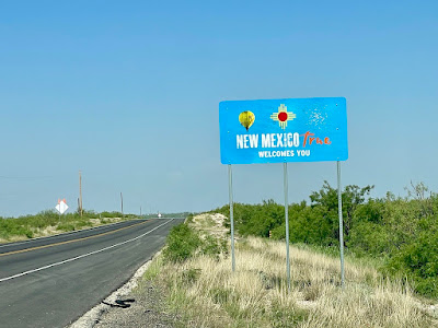
Before long, we crossed into New Mexico and into Mountain Time Zone, where we would stay for the majority of our trip. Compared to some others, this welcome sign to the state was not as impressive, but the license plates are definitely some of the nicest designed in the country that I've seen. There are two main styles that have either yellow background with red numbers, or a turquoise background with yellow letters, and we did see a red chili style as well, with a black background, with the slogan "Chili Capital of the World." My other favorite thing about the New Mexico plates are the fact that they specify "New Mexico, USA," perhaps to make it clear to any confused Americans that New Mexico is indeed part of the US, and not part of Mexico? If so, I am disappointed in our education system.

We stopped briefly in Jal, NM and drove a couple miles up the road to see a Cowboy Statue that was marked both on my map and on a green roadside sign. I was curious what we might see, but didn't expect this:

Cowboy Statues, Jal NM
These were much larger than you think, with the horses probably around 10-12' high, though the area was fenced off and we couldn't get too close. From here, we continued on through barren land along Route 128, with certain areas dominated by salty ground that I kept thinking was snow if I didn't use my brain to recall the temperature was in the high 80s. After spotting a very tall anvil cloud over the direction we were supposed to be heading, I checked the weather app, only to find that the cloud was directly over Carlsbad, and potentially dropping rain on that particular spot. The cloud got higher and higher, with strong upper winds blowing it to the east, but never moving.

A large cloud of Carlsbad Caverns
We cut off the corner from downtown Carlsbad, since we planned to go there after our cave tour for dinner, and instead passed through an interesting town called Loving on our way to Whites City, the gateway town for the national park. It turns out the cloud was not dropping heavy rain over the park, though the cloudscape was certainly interesting and dynamic. Perhaps there was rain above that was evaporating before it hit the ground...

Finally at Carlsbad Caverns!
I didn't realize that the main area of the park is actually on a mountaintop, so we had a long winding road to get to the top, and the cavern below is actually within the mountainside, 700 feet below the summit but still above the valley to the southeast. This park has no gatehouse, as the entrance fee applies mostly for the cave tour underground, and since we had arrived too early at Shenandoah on our first day, our stop inside the visitor center would be my chance to get the annual parks pass for the remainder of our trip.

One of many brightly-colored hot rods we saw in the parking lot here, I'm assuming this might be some type of group or car club that travels around different areas, since the license plates were from all over

We got our cave entrance receipt inside the visitor center, and headed the exhibit hall, which features a 3D model of the cave, which gives a slightly better sense of the geometry of the cave, however even still, I think caves are notoriously hard to visualize, since they are voids that twist and turn in 3 dimensions, and once I was eventually on the main path underground, I lost most of my sense of direction. There was a 2D map that showed both the surface features and also where the cave is below that was more helpful to me.

From the exhibit hall, it's a short walk down a path to the cave's natural entrance, where we saw the stone amphitheater where we'd be back in the evening to see the bat flight spectacle. (There is the option to take an elevator to the bottom, near to the big room area, and though we'd be taking this back up afterward, I think it's fun to see the natural entrance, which adds about one more hour to the underground trip.)

Carlsbad Caverns Amphitheater
I'll make my disclaimer now, which is that while photography is completely allowed in the cave, our pictures, and even videos, don't really show how it feels to walk through, and as I look over the pictures we took, it's quite difficult to discern what exactly I'm looking at. You'll see the trail with its railing in some of the photos, which help to give some sense of scale and depth, but walking along the path and seeing features appear around corners is truly the best way to experience it all. The way in past the amphitheater is down many switchbacks as we descend about 700 feet below the surface. Good shoes were recommended for this tour, though I did see one person in flip-flops, and I hope they didn't slip on the wet sections of the path...


The entrance area is inhabited by cave swallows, which we thought were bats at first, but then we realized bats don't make bird sounds, nor do they fly around during the day. The temperature difference as we descended was considerable, as was the increase in weird smells, no doubt from the bird and bat droppings, and the mixture of inside and outside air.

Looking up out of the natural entrance


A bit further down, we got to an area with a flat roof, descending even further down with switchbacks galore.

Just a bit of natural light finding its way in at this point
A big area of flowstone
A tall, but not the largest stalagmite, Yilin for scale
This map was the most helpful to me, and we chose to do the full loop on the right side


Above is a picture from the big room, where at most times you can see to the opposite wall. We thought this hole on the left looked like an eye!

See the pathway above where we came from

Dolls Theater: soda straws and small columns

A small mineral pool with a bit of rainbow colors, likely from bacteria
After about 2.5 hours underground, we had finished the big room loop and returned to the elevator station, where there was an underground gift and snack shop, though it was closed by this time since it was after 4pm. This just seemed so out of place to me, I have no words. Apparently there used to be more development underground years ago, but there were issues with animals getting into food down here, so they had to scale back on the amenities offered at the bottom. There are still restrooms if needed.


Exiting the visitor center and breathing clean air again was so refreshing, after we had grown accustomed to the somewhat stale cave air. The sky was threatening to rain as we got outside, but at least we weren't baking in the sun. Looking east out onto the forever flat land below was so cool, as was seeing the rest of the mountain range out to the right where Guadalupe National Park lay obscured by haze.


As we were looking around, we turned east to discover a rainbow!

We decided to drive up into downtown Carlsbad to get dinner at a Mexican restaurant called El Jimador. It's a bit further than it looks on the map, due to the winding park road, so it's about 40 minutes. We did get some rain on the drive up, but we welcomed that do cool us down a bit.

Yilin wanted to try something unusual on the menu, and went for their Molcajete Jimador - a meal that was served in a sizzling hot molcajete (Mexican version of mortar and pestle), featuring shrimp, chicken, steak, chorizo, onions, salsa, and cactus leaf. It turns out the cactus leaf is extremely sour, at least in the way it was prepared here, but otherwise, her review of the meal was quite good! I ordered Pollo Palapa, a comparatively more tame meal featuring chicken in queso with rice and beans, which I fully enjoyed.

Molcajete Jimador
We were watching the clock as we ate, since we needed to be back to the park around 7pm to get a seat at the amphitheater to watch the bat flight that evening, but we managed to eat what we could and pack some leftovers with us and get back with plenty of time to spare.

Now for the bat flight, I won't be able to show you any photos or footage of the event since any electronics are prohibited since the bats are very sensitive to light and noise. We were required to actually shut our phones off. I will try to describe the experience as best I can. We had a ranger answering some questions from our medium sized audience that night, and he instructed us to wave at him if we started to see any bats emerge from the cave, since he was facing our way. It was a few visitors next to us that spotted the first bats, and from this point he had told us to try and be as still and quiet as we could and just observe. Of course we're allowed to leave at any point, but just to exit quietly. Bats, unlike the cave swallows we saw earlier, must flap at all times to stay airborne, and because of this, the flight pattern is noticeably different, and more fluttery, since they can't glide. The primary bats here are Mexican free-tailed bats, which are much tinier than I expected, only 3-4 inches long, with a wingspan of about a foot. They came out in swarms, circling in front of the entrance to gain altitude before turning off over the mountaintop to look for bugs, primarily moths, to feast on. The ranger told us that they usually fly over toward the Black and Pecos River valleys, their flight distance averaging about 10-25 miles each night. It was quiet enough for us to hear the wings flapping before they disappeared into the sky—certainly one of the more unique experiences we have had.

I don't recall what time the bats started coming out, but we stayed for maybe 30 minutes watching them, before quietly sneaking out to our car. The sky had mostly cleared and we had a view of the crescent moon setting over the mountain.


I had found a nearby car-camping spot not far down the road called Sunset Reef Campground, which has about 10-12 spots for RVs or tent/car-campers, and there were only a few people set up by the time we arrived at 9 or so. The sites had picnic tables with a metal roof over the top which was quite nice, I would come back here if camping in the area.

Starry view from Sunset Reef CG

I had been poking around the map earlier and discovered Guadalupe NP just to the south was home to Texas's highest peak, Guadalupe Peak, and while I know Yilin wouldn't have much interest in doing this hike, I thought it seemed possible for me to give it at go since we were in the area, and she was fine with hanging out at the trailhead in the morning while I hike. The elevation of the summit is 8750', certainly higher than I'm used to on the east coast, but it was time to get back into some bigger hikes with a few thousand feet of elevation gain so my legs don't go soft sitting in a car for days on end. I was planning to get up predawn so as not to waste the whole next day. I'll save this adventure for the next post, and for now, leave you with our route map from Day 8.

Day 8 Route map: 274
Total mileage: 2592

Wednesday, May 28, 2025

2025 Road Trip: Part 7 (more Texas)

Dallas to Big Spring TX

Day 7
5.28.25

I was excited to heat up some leftovers from Riscky's BBQ to include in our final breakfast in Dallas - the smoked sausages were delicious with omelettes! We had a little bit of free time to spend before the Museum of Art opened at 11am that morning, so after somehow fitting everything back inside Apollo, ready for the journey ahead, we stopped to visit White Rock Lake, a reservoir near to downtown with botanical gardens on its eastern shore. We didn't have enough time to see the whole botanical gardens, so instead we found a nice view overlooking the city from Winfrey Point, surrounded by a meadow of various flowers.

We had some fun experimenting with my Nikon camera here, seeing how to best photograph each other among the many plant stems.

Yilin at Winfrey Point, White Rock Lake, TX
More Indian Blankets
A tiny green lacewing hanging out on Queen Anne's Lace

Our joyful romp through the meadow was cut short when Yilin discovered she must have stepped on a fire ant home by mistake, and consequently got stung on her ankle multiple times :( So we got out of there quickly and applied some bug bite cream asap.

Next stop was the Dallas Museum of Art, which apart from a few special exhibitions has free admission, and only had a reasonable parking fee for the garage if arriving by car. As many museums are, I felt this one was a bit of a maze, and since I'm writing about this a few weeks after the fact, I certainly have forgotten a few details. We saw some pottery and ceramic artifacts from all over the world, keeping our eyes peeled for unusual cat specimens of course. Sculptures of bronze and marble were centerpieces in certain rooms. A couple paintings of musicians caught our eye, a trumpeter, and a harp lesson scene, where I was pleased to see the F and C strings had been properly colored blue and red respectively!


I also found a playable kalimba (thumb piano) with an unusual scale that seemed to start in minor but finish in major. A big surprise was to find a painting of my twin in one room, so we took a picture together—I even had the right color shirt on that day!

These creatures below however must take the cake for the most interesting animal depictions of the museum. Your guess is as good as mine for what they might be, but the middle one is giving me vibes of Sid from Ice Age.

A portrait in the large atrium

After getting our fill of the museum, we got our steps in and walked a few blocks down to the Giant Eyeball, truly a sight of wonder in Dallas. Yilin correctly guessed that it would be a blue eye, not a brown one, so behold:

Dallas's Giant Eyeball
Yilin wanted us to visit the Chapel of Thanks-Giving, which is known for its unusual spiral shape and beautiful stained glass windows on the roof. When we arrived, nobody was there, and we got the interior to ourselves for a few minutes. The circular room was lined with chairs dotted around the edge, and we could look up to see a rainbow of color through the windows above.

Spot Yilin on the ramp below the spiral!
The stained glass from inside the Chapel
With a lot of Texas left to cross before getting toward New Mexico, where we'd be visiting a cluster of national parks and other natural areas, it was time to head out of town, but first I wanted to try another location to buy a Benchmark atlas for New Mexico. The REI staff from yesterday suggested I try Whole Earth Provision Co., which I did, however I struck out once again, since they only carried the Texas atlas, which we'd be leaving in a day, so I didn't find it worth purchasing. Instead, I decided to utilize Google Maps' feature of saving certain areas for offline use, for areas where we might be camping and have spotty service. I've used the feature before, but it seems to be easier to use now, and allows for multiple saved regions at once.

No trip to Texas would be complete without a visit to Buc-ee's, so I was determined to find one and check out what the big fuss is about. Emilia had sent me a small plushie keychain of Buc-ee the beaver since moving to the Dallas area, but I had to set foot inside one for myself. All I knew before is that they are known for having some of the largest gas stations in the world (the record holder is by Houston and has 120 gas pumps), and the accompanying stores are massive, and have an entire home goods section. We were eager to see what we would find there!

Turns out the rumors are true, and it's larger than some big box stores I've been to... and the choices of food were amazing. A barbecue bar with pulled pork, brisket, or chicken sandwiches being ready made, many flavors of jerky, Buc-ee's beaver nuggets (a sweet caramel puffed snack of sorts), ice cream and slushies, and more things than I can remember. So many types of clothing and gifts adorned with Buc-ee on them, including gaudy hot-pink swimsuits, the biggest cast iron frying pan I've ever seen, a camping gear section with grills for sale, and the aforementioned home goods section as well.

Buc-ee-mobile complete with a buck-teeth grill

We left the store with some delicious pork and brisket sandwiches!
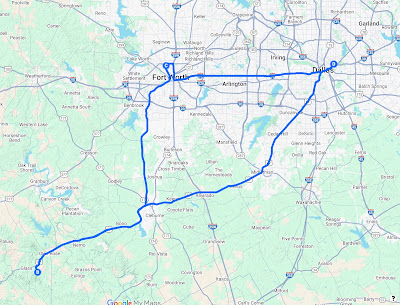
With our tanks full of barbecue, and Apollo's tank full of Buc-ee's gas, we pointed ourselves west and headed out of town, even though it was already after 5pm by this point in the day. We didn't have too far to cover this day, at least at Texas speeds, it wouldn't take forever. We were north of Fort Worth by the time we found Buc-ee's, so it was about 300 miles to Big Spring, where I was hoping to snag a free camping spot right out of town. We were full enough from our sandwiches that we didn't need to prepare a dinner at our campsite, in fact it would be quite late by the time we arrived anyway, so I thought it would be fun to meander a little bit before getting onto I-20 in Abilene, so we headed west to Jacksboro on US-380 in search of some wind farms. I remember on my last trip through Texas, which was further north near Amarillo, I was amazed at how many wind turbines were around, but with relatively flat land, it makes sense to utilize the wind that picks up speed here.

Texas has an interesting road structure, featuring FM roads (farm-to-market) that fall beneath state and US highways in the hierarchy. Despite their lower class, these roads are paved and maintained by the state, designed to connect rural areas to larger highways. For those looking to see more into the countryside of Texas, these roads are a good choice, as they hardly have any traffic and bring you through lots of pretty areas, but are still blessed with fast speed limits. We traveled on FM-4 for quite awhile, and did spot some wind turbines close (and cows) to the road, though the best views were to come later.

FM-4 near Jacksboro TX
One big problem with this type of landscape with lots of cows, is it tends to attract hordes of bugs, specifically mosquitoes, and in the evening they will quickly coat your windshield, significantly reducing visibility if traveling west into the sun. I made a quick stop in Albany to do some window cleaning, and pulled up to the Shackelford County Courthouse, a very cool piece of architecture in this otherwise sleepy town where I suspect everyone knows everyone.

Shackelford County Courthouse
We were stared down by a white a gray kitty who stepped by as I was pulling out of the parking area.  From here onward, the light was fading into a brilliant gradient of blue to orange to red, and as I approached the highway, Yilin grabbed my Nikon while we passed through a sea of wind turbines in every direction. Of many blurry photos (it was getting dark and she was shooting from a moving car, so no surprise) this one turned out really cool, and even captured a crescent moon near the top.

Wind turbines along TX-351, Shackelford County
The next hundred or so miles went by fast as we entered the interstate, hanging out with the late night crowd of truck drivers, and dreaming of how our upcoming days in New Mexico would be. My friend Noah had visited Carlsbad Caverns and White Sands National Parks on his trip from Maine to the Grand Canyon in 2014, and I recall his high praise of both locations, and thus quite excited to experience them myself finally.

We did better than our midnight arrival into the Arkansas campsite, as it was only 11pm as we turned off to Big Spring, where we'd be camping for the night. By this night, Yilin and I had gotten into a system of how we set up our camp for the night. The tent is easiest if we put it up together, and then she'll hop inside and inflate our air mattress, and once it's ready I can hand in the rest of our bedding/supplies from the car. Tonight's campsite was on sandy/rocky soil so no tent stakes, but instead we use the desert style - tie some string around rocks and loop it through each corner of the tent. If we were eating dinner there, I would also get our cook set up and start cooking as well, but no need for it this evening since we were still full from Buc-ee's. The temperature had been on the warmer side so far, but was comfortable with just a blanket and we didn't have to bring out the sleeping bags (yet...), and the air was pleasantly dry out there.

After spending a few days in Texas, and visiting at least Dallas and Fort Worth, I have to say I was surprised much I liked it. For some reason, I've always had a weird feeling about the state, either from hear-say, or stereotypes of crazy cowboys, which I'm sure exist, but overall I enjoyed the food scene—it's great if you like BBQ and big portions of it lol, as well as the chance to see a place like Fossil Rim, and more of the countryside.  One disappointment was not being able to witness a Texan create their own exit off the highway by driving into the grass onto the frontage road...I've seen videos but I hoped to witness it firsthand...I guess I'll have to come back!

Day 7 Route map: 368 miles
Total mileage: 2318

Tuesday, May 27, 2025

2025 Road Trip: Part 6 (Fossil Rim)

Fossil Rim Wildlife Center

Day 6
5.27.25

This may be the day of the trip that turned Yilin into a wildlife enthusiast, because from this moment, wildlife encounters and opportunities to photograph them doing funny things were highlights of any day for her. The big expectation for our visit to Fossil Rim was the chance to feed giraffes from your hand: we read that they are the only animals that can be hand-fed pellets provided at the admission office, the remaining animals have to eat them from the ground.

We read that the best time to see as many animals as possible is to go early in the morning, so we booked entry tickets for the driving tour fairly early, at 9:30, since we'd have to drive over an hour to get there. For some background, Fossil Rim is an animal conservation organization that offers species in peril a near-natural living space with lots of space to roam and forage, while also giving people a chance to see many of these amazing animals: giraffes, wildebeests, oryxes, cheetahs, gazelles, emus, zebras, various types of deer, antelope, rhinos, and ostriches. We got to meet many different animals, and I hope to correctly identify them all in the pictures of this post...apologies if I make any errors, and please comment below so I can make corrections!

On our way to Fossil Rim, we encountered another "Unusual Modes of Transport" bingo item, that being "person walking on the freeway." It happened so fast I didn't get photo evidence, but it occurred on US-67 on our way southwest on this morning.

Upon arrival, we saw a few other cars and some families lined up to take the other type of tour you can book here - safari style bus tours, each of which were painted in zebra or cheetah print. We opted for the drive-yourself version since it would give us more freedom to go at our pace as we saw various animals. No matter if you book the safari tour or the self-guided tour, you get a bag of food pellets to feed various animals along the trip, and the key is to ration it properly so you have some left for the giraffes! They estimate 2 hours to drive along the 7 mile loop, but we clearly exceeded that since I had fun looking for harder to spot animals, and Yilin wanted to take many photos of every animal that approached the car. It was so nice to have my Nikon camera with me on this trip, as its 30x zoom allows for some highly detailed photos without getting too close to animals or birds.

I've selected our best photos to represent each animal we saw along our trip here, as well as notes from their animal guide, so enjoy the show below!

Common Wildebeest
Known for their 1,800-mile annual migration across the African plains. Almost immediately after birth, a calf is able to stand and run alongside its mother. Silvery-gray, they are also called blue wildebeest.
Blackbuck (male)
Adult males are black, while females and calves are light tan. Only males have horns, which are ridged and spiraled. Because the genders look drastically different, blackbuck are considered sexually dimorphic.

Indian Blanket
Scimitar-Horned Oryx
Scimitar-horned oryx were classified as extinct in the wild in 2000. However, a reintroduction program project with Fossil Rim began releasing this species into Chad in 2016, and the species was reclassified as endangered in 2023. Named after a scimitar sword, it is the only oryx with curved horns.
Emu
The emu is the second-tallest living flightless bird. It is thought to have roamed the outback of Australia 80 million years ago. The Australian government has protected it since the 1960s. Emus are monogamous. The male incubates eggs and guards chicks for up to 18 months.
Dama Gazelle
The largest gazelle species. The dama is diurnal and requires lore water than its desert neighbors, although it can still survive long periods of drought. It is highly nomadic, ranging extensively in search of food and water.
Addax (looking for a treat?)
The best desert-adapted antelope, addax can survive for long periods of time without drinking water, instead deriving sufficient moisture from plants. An addax reintroduction effort began in Chad in 2020, as staff from Fossil Rim traveled abroad to assist with the release.
Fallow Deer
Even in their native Mediterranean countries, most "wild" fallow deer are semi-domesticated. These are the only Fossil Rim deer with palmate (broad, flat surface) antlers.

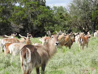
Common Waterbuck
An oily, musky secretion from the skin serves a waterproofing function. Waterbuck must drink daily, so they never stray far from water and are good swimmers. Only males have horns and serious fighting is more common than in most ungulates.

Giraffes (back)
Giraffes are the tallest living land mammals and, although it looks like their hind legs are shorter, all four legs are almost the same length. Its mouth is soft with a hairy upper lip and purplish tongue that is nearly 18 inches long.

Roan Antelope (front)
The fourth-largest African antelope, roan males can weigh 660 pounds. Like most horse antelope, they are gregarious and territorial. Herd sizes are smaller for roan than similar antelopes, and they maintain a greater individual distance apart. Bonds between calves can be stronger than mother to offspring.

Blackbuck (female)

Northern Mockingbird (this wasn't in our animal guide, I just happened to see one)

A curious giraffe approaches...perhaps to be hand-fed?
Lunchtime for the curious giraffe!
A giraffe army passes

This must be the extra-long tongue they mentioned

Hartmann's Mountain Zebra
Unlike other zebras, the mountain zebra has a dewlap, or fold of skin, hanging from the throat. The Hartmann's have a white belly, like the Grevy's, but Hartmann's have much wider stripes. If surface water is not available, wild Hartmann's will dig for subsurface water.


Scissor-tailed Flycatcher (also not in our animal guide, but I loved the peach color of the underside)
Black-tailed Jackrabbit
Despite its name, the black-tailed jackrabbit is actually a hare. Rabbits are typically much smaller than hares, with shorter legs and ears and a much stockier frame. Hares have long, powerful back legs and thin bodies that allow them to run rather than hide. They are much better suited to habitats without thick vegetation, and don’t burrow underground like rabbits.
Possibly a melanistic female blackbuck? We thought she looks a little burnt!
Aoudad
The aoudad is the only African sheep. Its eyes could be considered its most remarkable feature with horizontal pupils surrounded by brilliant-yellow irises. It is a very agile climber and jumper.
Aoudad #784 came to inspect us in the car
Fallow deer (front) with female blackbucks (back)

Cheetah
The cheetah can reach 65-plus mph in seconds, but can only run for 400 yards before exhaustion sets in. Oversized nostrils, flexible spine, enlarged heart, and increased lung capacity all benefit the fastest land animal.


South Central Black Rhino
Black rhinos can be identified by their prehensile upper lip for browsing, while white rhinos have square lips for grazing. Males may tolerate other males if they remain submissive.

Ostrich
The largest living bird, the flightless ostrich uses its wings mainly for communication, courtship displays, and helping to turn or brake when running up to 45 mph. Ostriches have excellent vision and very powerful kicks. The largest eggs weigh three pounds and are equivalent to 24 chicken eggs.


The ostriches concluded our 3-hour trip through Fossil Rim, quite a bit longer than they advertise, but that was the joy of taking the self-guided tour. The loop is two lanes wide so people who want to stay longer in any spot can easily do so while not holding up any other visitors. About halfway through, there is a short turnoff to a small gift shop and cafe atop a hill overlooking the valley. Inside, we saw an "I fed the giraffe" shirt which seemed fitting, but instead opted for another set of matching T-shirts with illustrations of a bunch of the animals we saw. Yilin also spotted one of those penny-press machines where you can choose a picture and it rolls the penny out into an oval. I only learned this later on in the trip, but apparently there's a whole database map of where all these machines are in the country - a helpful tool for collectors, of which Yilin is now one, with a little passport book for them and all!

~ ~ ~

Fort Worth Stockyards

After a very fulfilling and exciting morning viewing wildlife, we headed back toward Fort Worth to try and reveal our true Texan spirit at the Fort Worth Stockyards, the only location to offer twice-daily cattle drives! They have rodeo shows on weekends, but we'd have to do without that since we happened to be passing through mid-week, and decided to have lunch at a roadhouse style place called Riscky's BBQ, one of the several eateries to be found in this very cool cobblestoned pedestrian plaza. We ended up with enough food for a family of four it seems like, since we wanted to try so many things: deep fried brisket bites, loaded potato skins, smoked ribs, sausage, and catfish (who knew this was a smokable item!) Despite our (my) best effort, we needed takeout boxes for leftovers.

While waiting for the 4pm cattle drive, we explored some of the weirdest shops I've ever seen, as well as some very cool leather goods places with ungodly prices. We saw a cowboy offering a chance to sit on a Texas longhorn, and I still can't believe how long the horns are, and how it's not a huge inconvenience for the cows.

Texas Longhorn cowboy
Shortly thereafter, we saw a bunch of cowboys on horses getting ready for the cattle drive, with one speaking over the microphone. (We kept looking for him to the left, but it turns out he was to our right and we were fooled by the speakers.) 


Extra-longhorn cows!
The actual cattle drive was very short, only a few minutes, but really cool! I recommend any visitor to the Dallas/Ft. Worth area come and see it if you can. You come for the cattle drive and stay for the bizarre taxidermy animals in the adjacent shops. Just in taxidermy form, we saw a raccoon band featuring an accordion, a raccoon cellist, a pole-dancing mouse, canoeing squirrels, an eel(?) eating some type of rodent, alongside plenty of large and non-native animals - elephants, lions, ostriches, a polar bear. It felt like cowboy nirvana, I think?

For all your taxidermy needs
Just an average gig for this raccoon
Yilin has turned full Texan
Editing my post to include this split-windshield truck outside of the Stockyards shops
Our stomachs full and our brains confused at what we've just seen in the shops, we meandered over to the cultural district to walk off some of our lunch at the Trinity Park Duck Pond, and enjoy the early evening under the shade, accompanied by a multitude of ducks, geese, grackles, and turtles.

Trinity Park Duck Pond

We finished out our full day with a short walk through the Fort Worth Water Gardens, which featured three different areas—a terraced waterfall pool, a quiet pool lined with trees, and an aerated pool with misty fountains spraying water up. The terraced waterfall pool was the most fun with its walkway down to the center where we could be surrounded by the rushing water.


After the Water Gardens, I tried visiting REI to see if I could acquire a Benchmark atlas for any of the western states we'd be spending some time in (New Mexico, Colorado, or Wyoming), but they didn't have any at the location I visited. Usually I'm a big fan of Delorme's state by state atlases for back roads, but I recently read that Benchmark makes a slightly better product for the western states, and I thought it would be helpful to have those atlases in case we run in regions without cell service. (Worry not though, I do have the complete North American atlas by Michelin - I'd never do a trip without it!)

It was 9pm by the time we got back to our little green AirBnB house, and there was little to do except try and get things mostly packed for our departure in the morning since we wouldn't be coming back to the house. On our agenda for the next day was the Dallas Museum of Art, which opened late morning, giving us a little time to sleep in, truly a luxury on our full schedule.

This day seems so much longer writing about it and curating all the photos I wanted to share for it, but I hope you've enjoyed following our journey! Yilin did a great job planning out our time in DFW, and it's really best if I stick to planning anything nature or wilderness related.

Day 6 Route map: 258 miles
Total mileage: 1950