Cerro Quemado
Day 15
4.28.15
I spent 3 nights in New Mexico, and even after seeing some of the most amazing things on my trip so far, I felt ready to leave and head further into Arizona. I had been booked to hike with Noah in the Grand Canyon for three days from May 1-3, and I wanted to arrive early enough in Flagstaff to go over our gear, possibly go on some smaller hikes before hitting the real thing. Going all the way today would give me two days of prep time, which would be perfect.
Within 60 miles or so, I had reached the Arizona border, which I was excited about to say the least. After hundreds of miles of flat New Mexico, I was ready for something new. And surprisingly, not far after the border, the landscape did change!
 |
| Entering my 15th state along the trip. |
I started to see more trees, more hills, and I entered the region of the White Mountains. These are the White Mountains of Arizona, not anything like those of New Hampshire. These are more like mini volcanos that are covered in a light grass.
If you know me well, you know what happened when I saw one with a road going to it.
 |
| Cerro Quemado, or what I believe to mean "burnt hill" |
The road was pretty straightforward to begin with, though a few places were rutted out.
 |
| About 2/3 of the way up. Summit "road" on the right. |
 |
| Summit of Cerro Quemado, 8087' |
After taking it all in for a few minutes, I faced the fact that I had to get the car down that steep hill again. Time to downshift. Even so, I had to creep down ever so slowly to avoid punctures on sharp rocks. There is not much that's thrilling like this kind of driving is. For reference, I did calculate the slope of this steep part, and it came out to a 1:3 gradient, a 33% grade, or an 18.5° slope. You typically see signs for a steep slope if the grade exceeds 6-8%. This is a whole new kind of steep, but very fun to test out Wombat's capability.
 |
| Heading down, looking north |
 |
| The view down. |
I arrived and was not excited to pay an entrance fee of $5, but after seeing the park, I would have gladly paid $10 or more since this place is a hidden gem in the National Forests of Arizona.
 |
| View from one of the upper viewpoints they have. |
There were many different kinds of rocks down below, though many of them were polished very smooth from all the traffic that passes along the path.
I was grateful to have visited Mammoth Caves prior to this, since I was able to understand a bit more about the formation of this archway using that knowledge. In the picture below, you can see bits of dripstone, forming fins along the limestone wall.
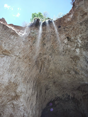
What I was staggered by was the size of this archway. From the top, it looks a bit understated, but once you go down and stand in the entrance to it, you see that it is probably 150-200 feet tall inside, depending on where exactly you stand.
A stream runs through the arch, creating deep pools that they warn you not to swim in. You still get quite wet while crossing from one side to the other because unlike Mammoth Caves, this arch does not have a sandstone "roof" on top to seal out the water. This results in lots of dripping, holes, and some small stalactites. There were birds nesting in several of the holes near the top. And to top it off, the far side of the arch had a beautiful waterfall coming off the top. I was torn between posting a picture from this side or from inside the arch, because they are both pretty cool I think, but I thought this was a slightly nicer shot.
I continued west along Rt. 260 into Cape Verde, which brought me to I-17 northbound, and then Flagstaff! Flagstaff is cool for lots of reasons, but here's a few:
- It was the first International Dark Sky City
- Pluto was discovered here at Lowell Observatory
- The Grand Canyon is only 80 miles away
- Humphrey's Peak (12633), AZ's highest point is only 14 miles away
- Everyone I've met here absolutely loves the outdoors
Since I've been staying with Noah, I have realized that the view along the road is one of the best you could probably ask for. This is the view north to the San Francisco Peaks, the tallest of which is Humphrey's Peak.
 |
| San Francisco Peaks |
The last leg of my journey to Arizona is 346 miles, which brings to total up to 4482 miles. I consider this section to be Leg 1 of my Road Trip, since I planned to spend a longer amount of time here, exploring the area with Flagstaff as my home base.
I've been doing a few things around and about near Flagstaff since my arrival, so in the next few posts, I will try and be inclusive for those of you not coming from facebook, but also not repetitive for those of you that are coming from facebook.
I hope you're still enjoying reading about the trip as much as I'm enjoying it in reality (and also writing about it). Cheers for now.


No comments:
Post a Comment