Spoiler alert: this hike includes excessive water content, and limited visibility at viewpoints.
I did things a bit silly this week, and hiked on the wetter of my two days off from work. Oh well! True adventure takes place in all weather conditions right? That's correct. I certainly got my fair share of wet trails. I thought for some reason I might be able to get through the day with dry feet. Several minutes after departing from Jordan Pond House, the concept of dry was to be erased from all memory.
 |
| A stream crossing on the edge of Jordan Pond |
The crossing immediately soaked my feet because the rocks were submerged a few inches. With the day off to a good start, I headed up the trail to Pemetic Mountain (1247'), a new destination for me. And I may as well have not gone because this is basically what I saw for the whole time I was above tree line:
 |
| Killer views from Pemetic ridge |
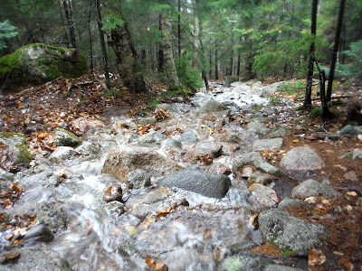
Instead of the typical hike where you look forward to the summit and other points along the trail where you can look out to the ocean and see how picturesque Acadia is, my goal for the day was not to kill myself on the trails, which were dressed up as streams for Halloween (a few days early). The trail I took down from the summit was the Pemetic Northwest Trail, which leads to the Park Loop Road and later to the Bubbles, which were my next target in sight.
 |
| An example of the trail conditions we're talking about |
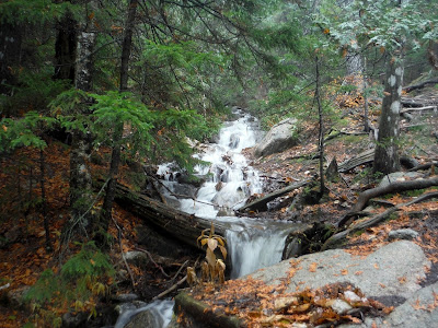
I was surrounded by waterfalls all day today. It may have something to do with that 2 inches of rain we got last night. But for those of us who are waterfall enthusiasts, today is the day for you! Here is one of many I saw.
 |
| Waterfall on Pemetic Northwest Trail |
I soon discovered that the stream that was running next to me on the right was normally a trail in lower water levels. Thankfully, there was an option to stay on the ledge, which I took as a safety measure.
 |
| I don't think this is what a fish ladder is... |
I crossed the Park Loop Road, and began the trek up to the Bubbles, and hopefully the notorious Bubble Rock (or Bubble Erratic as it's sometimes called).
 |
| The trail up to the Bubbles Divide |
The Bubbles are very accessible, seeing as there is a parking area right off the Loop Road if you are interested in doing a short hike up to just the Bubbles. However, they make a nice addition to a longer loop hike.
 |
Summit of South Bubble (766')
Again, terrific views all around! |
Bubble Rock is right past the summit of South Bubble, and I'm guessing it would be quite spectacular on a sunny day. It was indeed a step up from mediocre on a day like today. My face is in the photo for scale, if it helps at all.
Just opposite the Bubbles Divide lies North Bubble, at 872'. I cannot comment on the comparative views from each. I think they were both equally okay, though the South Bubble can claim the erratic as its own. If you must hike only one, I vote for South Bubble.
 |
| On the east side of the Bubbles Divide |
The trail then led to the north shore of Jordan Pond, which was quite spooky with today's weather. Maybe spooky is the wrong word...ominous is better.
Spooky belongs to the photo below, some trees I saw jutting out over the edge of the pond.
Kudos to the trail crews in the park for building this nice bridge. I never got to build bridges on trail crew at BSP, but I can appreciate the work that goes into maintaining trails nonetheless.
 |
| Fancy bridge! |
From this side of Jordan Pond, I headed up to Penobscot and Sargent Mountains. I hiked both of these in November of 2013 with Gugen and my cousin Julia. This was my first cold-weather hike, and I was really badly dressed. I have learned much on layering since that hike, not to mention that microspikes are a great idea if you are hiking on icy trails.
This trail to Penobscot Mtn. was perhaps one of the most wet experiences I've had aside from the occasional swim. The trail crosses back and forth many times, which normally is not an issue, but with high water, each crossing takes a bit of planning to not slip in and die.
 |
| Another roaring waterfall along the Deer Brook Trail up Penobscot Mtn. |
I came upon one of the many beautifully constructed granite bridges of the carriage trails in the park.
 |
| A peek through the bridge |
I didn't take a picture at Penobscot Mountain, but the elevation at the summit is 1196'. About a mile further is Sargent Mountain, the highest point on my hike. Below is my summit photo from there.
 |
| Sargent Mountain, 1379', mountain #5 of the day |
From here I went on to explore some more peaks that I hadn't been to before. Next up was Gilmore Peak, just across a small valley to the west. Because everything (I repeat, everything) is soaking wet, I found a section of trail between Sargent and Gilmore that had some epic foam on it from the excessive water flow. I still don't really know what causes the foam, but it's pretty cool.
Right before Gilmore, I saw some people, the first ones of the day. To be honest, I was surprised to be seeing anyone at all on such a dreary day. A quick jaunt up from a stream brought me to Gilmore Peak.
 |
| Gilmore Peak, 1036' |
The ledges around here were bright with the red leaves of [insert plant name here]. It was a great contrast against the green of the conifers.
I went to Parkman Mountain and Bald Peak via the Grandgent Trail, on the next set of hills west of Gilmore. (This may sound like a lot of mountains, but keep in mind these are all pretty close to one another.)
After coming down Bald Peak via the...you guessed it: Bald Peak Trail, I came to a carriage trail. From here, I was going to walk along that for a few miles until a foot-path took a shortcut back to Jordan Pond House where I was parked.
 |
| Another bridge on the carriage trail |
Not far along the carriage trail, I met some people who were from New Mexico, visiting Maine for the first time. They were photographing this very waterfall (below). I was excited to share my three days worth of experience in NM from the road trip I took this past spring.
 |
| Well marked junctions on the Carriage Trails |
And because my feet weren't wet enough from all the stream crossings, and trails that were gushing water themselves, I had another wider crossing with submerged rocks once again. ALWAYS make sure you re-soak your feet in a stream or puddle at least every 30 minutes on a hike. It makes them disintegrate faster.
The last portion of my hike was along the Asticou & Jordan Pond Path, which takes a more direct route than the carriage trails. It is pretty flat around this part of the park, so it's not a hard end to the loop, but just a bit wetter than the dry carriage trails.
 |
| Along the Asticou & Jordan Pond Path - still cloudy up there |
A funny tree root made an appearance around the last mile or so. It seems as though maybe a rock was in there, and then they pulled it for trail work or something? Typically trees do the whole path-of-least-resistance thing, and that doesn't seem to fit the pattern any other way.
Soon, I made it back to the parking area (marked with the arrow below). Despite hitting two previously done peaks, I did some serious red-lining in the park today, though I'll have to go again to get the views. Maybe this winter will allow for some snowshoeing in the park.
Here is the Google Earth track and elevation profile. The mileage was about 11.5 miles, including the carriage trail component. (I went anti-clockwise, just FYI.)
Hike Data
Miles hiked: 11.5
Time elapsed: 5.25 hours
Total ascent: 3840'
Here was a shot of the (finally!) clearing skies as I drove home.


Wow! I can't believe that it rained that much at Acadia in October. I was there for 10 days in late Sept and it was nothing but blue skies for the most part. I took a lot of video there...I uploaded my Pemetic Mt video to YouTube today.
ReplyDelete