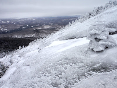
Though this hike took place on December 30, I consider it a New Year's celebration for the year of 2016, a tradition I have had going with my friend Eliot for three years now. The temperatures have steadily climbed about 20°F each year, with our first attempt up Old Speck in January of 2014 in the neighborhood of -20°F. Twenty above is quite balmy in comparison.
The Baldpate expedition commenced at 3:11am, after a good scraping of the windshield. Off to pick up Eliot, then heading westward to the mountains. Baldpate Mountain is accessible via Grafton Notch State Park, exactly opposite the trail for Old Speck. Baldpate is known for open granite faces on the summit dome, and is potentially a good observation point because of this. We arrived at the trailhead somewhere in the 7am zone, and took a meaty amount of time to get our gear all packed and our bodies warm enough to consider venturing into a winter wonderland.
 |
| The Eyebrow of Old Speck |
The trail to the summit is a section of the AT, so as per usual, the snow blown on the tree trunks made finding white blazes a good challenge. The trail was wide and easy to follow to start off, though we were first to venture out after the storm had blown through. Not enough snow for snowshoes, so we left them in the car. There is nothing quite like kicking into fresh powder in the mountains. The coziness that exists because of the snow's insulating properties is unmatchable elsewhere. This is one of many reasons why I am now a four-season hiker.
There is a fair bit of up and down in the trail, as you meander between bumps on the western side of the mountain. The AT does summit the west peak of the mountain, with views eastward toward the main summit.
The Table Rock Loop is a popular short loop that is partially congruent with the Baldpate Trail. I have gone up to Table Rock in summertime, though it was via the much steeper Table Rock Trail, and then down the AT that we were ascending on this trip. The trail out to the overlook is a 0.5 mile spur from the AT, and for purposes of summiting, we did not check it out...slight regrets, maybe.
In the final col between the unnamed bumps to the west and the West Peak of Baldpate, there is a lean-to, directly after which the trail ascends steeply with meager attempts at switchbacks. It was here we first encountered ice flow along the trail, and broke out the axes for stability. Crampons seemed a bit much for here, since it was such a small section.
The lands flattens, and you can sense you are close to the top of West Peak. The top is wooded, however a short walk past it will give phenomenal views into the upcoming saddle before East Peak. In the wintertime, the bald granite slabs up the opposite side of the saddle are covered with ice and stand out well from the forested areas. I was surprised at the calmness of the air around the west summit, albeit thankful since it allowed for easier munching of snacks.
 |
| Nearing West Peak |
 |
| Eliot on West Peak |
 |
| One of two ladders between the two peaks (just before applying crampons). |
 |
| Equipped |
 |
| Climbing! |
The rime up near the top was thick, and made it hard to look for the summit sign that we were searching for. The short stubby trees looked much like a rime-covered signpost. With help of a GPS to guide us in the cloudiness, we did make it completely to the summit, which is self-advertised as 3812'. Interestingly, this mountain has more gain than Old Speck, at 4170' feet just across the notch. This is because of the up-down-up characteristic of Baldpate.
It was up here that the wind did make an appearance on stage. But like semi-smart climbers, we had acted in advance and applied extra layers. There is certainly something to be said for anticipating your environment.
The descent was nearly the same, though we kept crampons on until before we had applied them on the ascent - just until the ice flow that we first saw. Descending on rocks buried on snow was tiring and dangerous for our ankles, so we bare-booted it from there to the bottom, sliding a good portion of the way.
 |
| Just before descending the bald patches of rock and ice |
 |
| Alpine Sandwich, nothing like it. |
 |
| Heading back to West Peak |
 |
| A final look at East Peak |
We discovered fresh tracks on the Table Rock loop, so sadly we did not encounter them, but their essence continues on until it snows again. The parking lot was soon in view, and the removal of boots was already being anticipated. I can only speak for myself, but I found I was not overly sore in the ankle/foot department considering I was in completely new footwear. It seems I made a good choice on boots.
Here is the elevation profile and track from Google Earth. Eliot's GPS claims it was 8.2 miles, so perhaps that is what it is? The map says 7.6, but I trust a GPS a bit more since it was with us the whole time.
Hike Details
Miles hiked: 8.2
Time elapsed: 10.9 hours
Total ascent: 3300'


No comments:
Post a Comment