Showing posts with label arkansas. Show all posts

Monday, May 26, 2025

2025 Road Trip: Part 5 (AR-TX)

Arkansas to Dallas, TX

Day 5
5.26.25

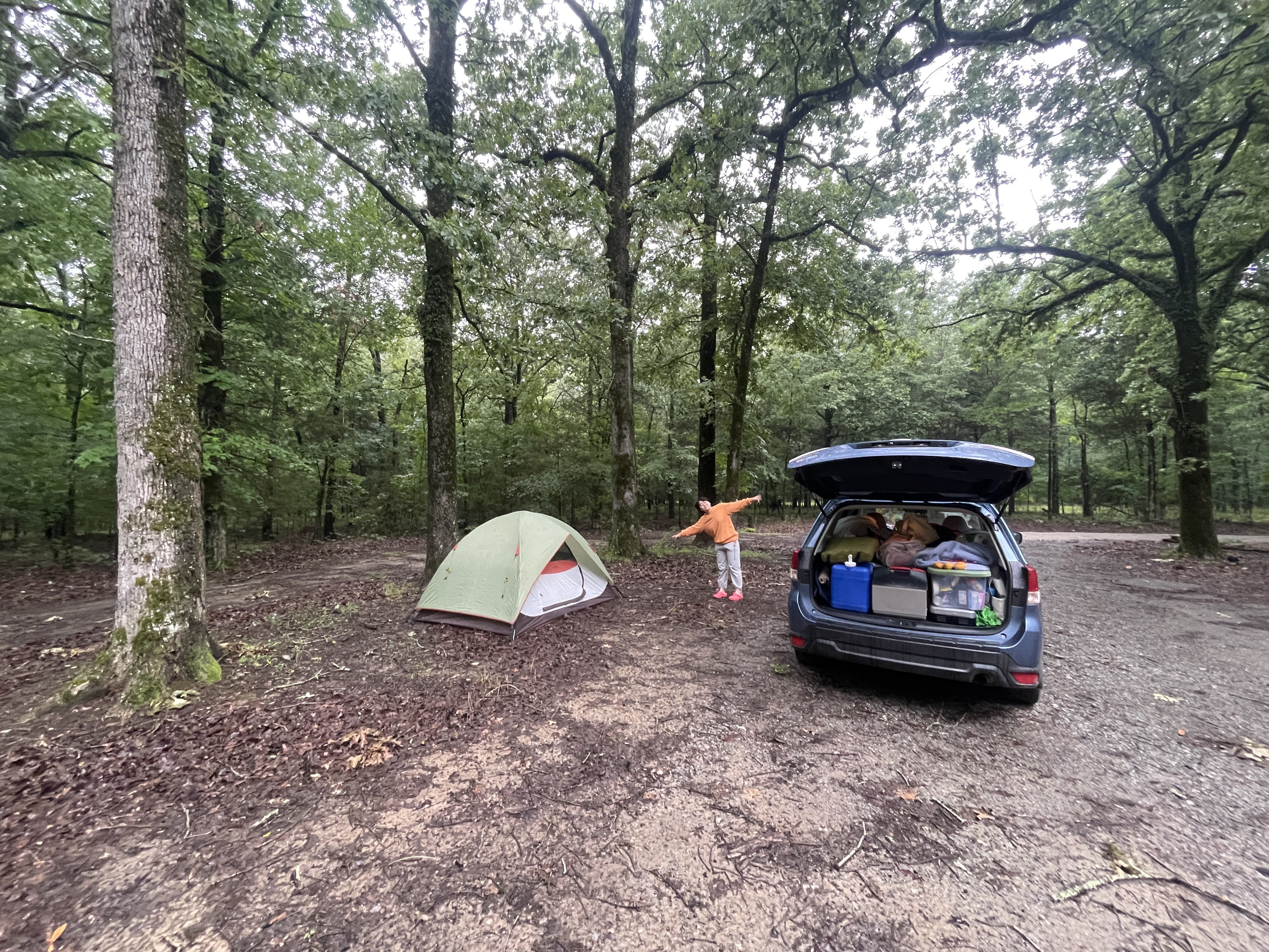
It seems that every time I visit Arkansas, I end up trying to avoid getting soaked by rain. Thankfully there was no downpour overnight, but after the previous day's storms, and I suppose with the humidity, everything was just as wet outside in the morning as it was when we arrived the night before. This was our second night using the tent on the trip, since Benny was kind enough to let us sleep inside the house during our visit :) and although the water drips from nearby trees were loud, we stayed nice and dry inside the tent.

By mid-morning, we reluctantly exited the tent and packed up, trying to shake off water as best we could.  Lacking any sort of campsite amenities (read: picnic table), we opted to stop by a rest area close by off I-40. This was one thing I was going back and forth on in the prep phase - should I get a small folding table for cooking on? I didn't get one, and honestly this would have been one of the more helpful items to have considering our campsite choices at times.

Leaving Watensaw WMA

Driving out of Watensaw WMA was very colorful, as green flora always seems more vibrant after rain despite other colors appearing more muted. We had a few miles of green tunnel along a gravel road before turning onto paved roads that led us quickly back to I-40. I did stop once to clear a rather large tree branch that was partially blocking the road...all I can say is the working trail crew at Baxter State Park has forever changed me, and I can't see a branch blocking the way without stopping to clear it.

Our chosen rest area was perfect, featuring a multitude of covered picnic tables. The only downside of stops like this is the road noise, which I try to avoid by going to other places to enjoy meals, but on a day that we expected some rain throughout the day, I'll take the roof over a picnic table, thanks.

I was excited for breakfast, which was going to feature some sausage and eggs cooked on my cherished cast iron pan - a big upgrade for this road trip compared to a cheap "non-stick" pan. Even cheesy eggs clean up pretty easy if you fry some sausage or other meat first, and we were both happy to enjoy a hot breakfast in the drizzly morning.

Tasty breakfast of eggs and sausage

The fun and games ends here however, as I made an unlucky move trying to load our kitchen tote back into the car while wearing my hooded raincoat. I smashed my forehead into the hatchback pretty badly because I was loading from the curb, meaning I no longer fit underneath unless I duck. Many expletives followed, as this hurt so badly, and I was convinced I was going to have a goose egg on my head for a few days. At least it wasn't bleeding, though Yilin tells me the red mark was quite visible nonetheless.

Sealed tightly inside the car after breakfast, we decided to stop at the next CVS in Little Rock for some arnica gel to ease my swelling. I can't believe how well this worked, as I've only used this on occasion before for muscle pain, but it seemed to do the trick for this as well.

From here, it was a straight shot along I-30 down to Dallas, where we'd be meeting Emilia for some BBQ in the evening. Seems like it's true that everyone drives faster in Texas, even the truckers, and that means you gotta rush so you don't get run over. The weather dried out as we made our way west, though it was still cloudy (the best conditions for a road trip honestly, otherwise you bake in the car).

I was not prepared for just how far things are in Texas, and I had it in my mind that Dallas was just past the state line in Texarkana, but I was wrong. It's another few hours further before we started to see signs of the Dallas metro area. Emilia texted us as we neared saying it was pouring rain again, which we could see on the radar map I'd been monitoring all day in case something crazy developed on our route. Also, the sky was a very strange shade of gray and weirdly smooth yet dynamic for storm clouds, but I figured that must have been the system she was talking about since it was dead ahead of us.

It was about 4:20 when we made into town, where Yilin had found us an AirBnB to stay at close to downtown Dallas, and we managed to miss the rain (for now). We were staying in this quaint green house just northeast of downtown that had an alligator sculpture on the table outside, and a shy cat hanging out on the porch, but most importantly for us, a place to shower and get cleaned up, and a fridge to store our cold food for a couple days while we explore the area.

The welcoming scene at our Dallas AirBnB
We planned to meet Emilia at Ten50 Barbeque, about halfway between us and where she was in Plano, and we were all excited to get some food there! The format of this place is you walk up to the meat station outside and order what you want there, and take your tray indoors to get your sides, desserts, drinks, and any sauces you want. We decided to get an assortment of things to share, including some pulled pork, beef brisket, jalapeƱo sausage, onion rings, and a few side orders. Yilin tried a peach mule to accompany her dinner, which looked quite fancy, though I can't comment on the taste as the designated driver for the trip. Right next to where we sat down was a Chevy split-windshield truck, with a flat bed hauling wooden barrels on display among the tables. Pretty cool to see it even if it's not drivable.

Ten50 BBQ centerpiece

Peabody Reunion, Dallas 2025
It was fun to catch up with Emilia and hear how her time at UNT has been for the last few years, and also congrats on graduating this spring if you're reading! Sadly we didn't get to spend more time together since she's a busy music teacher and had a bunch of lessons to teach the next day, so we Yilin and I were on our own for the next couple days. I had left this portion up to her for planning what we should do and see, since I'm notoriously bad at visiting cities.

In her research as we approached Dallas, Yilin made us a great itinerary of things to do, including visiting Fossil Rim Wildlife Center, about 80 miles southwest of the city, and then hang out by the stockyards in Fort Worth for the afternoon. On our second day, we would check out the Dallas Museum of Art, the Giant Eyeball, and the Chapel at Thanks-Giving Square. And one doesn't leave Texas without visiting Buc-ee's, so that was on our list as well.

Neighborhood cat on our porch

Our eyes set on hopefully seeing and feeding a giraffe (among other animals) at Fossil Rim the next morning, we got some well-earned rest after a couple long days on the road.

Day 5 Route map: 363 miles
Total mileage: 1692

Sunday, May 25, 2025

2025 Road Trip: Part 4 (NC-AR)

North Carolina to Arkansas
and a Tornado Warning?!

Day 4
5.25.25

All intentions of getting an early start to accommodate the miles we hoped to cover this day failed miserably. Turns out it feels good to rest and sleep in a bit, so the waffles became more of a brunch meal. We enjoyed them with various toppings, Yilin taking a particular liking to the crispy waffle.

A tribute to Union College's "Waffle Tuesday" events

Benny's mom had specific instructions that anyone that visits the house write in the journal (the latest of a whole stack dating back to 1999), so we made our contribution on, sharing thoughts and musings of our visit, and a few tiny illustrations as well, for good measure.

After filling up our big water tank and trying our best not to forget anything, we were on the road just before 2pm, with hopes of getting to Arkansas by the end of the day. This would mean not meandering around nearly as much compared to the first few days. The plan was to get on US-64 toward Chattanooga, follow I-26 for bit, and then follow US-72 through the northern tips of Alabama and Mississippi, which would add new states for me. Past Memphis, we'd be on I-40 as I'd found some dispersed camping sites within the Watensaw Wildlife Management Area not far from the highway.

Now I've had an idea that I wanted to have some fun with on this trip, which was supposed to be a set of bingo sheets for various categories of things we see along the way, but due to my last minute preparation nature, it still sits as a list of items to be checked off on my phone's notes app. The category that I'd like to feature today is "Unusual Modes of Transport", on which I've listed a split windshield truck (shout out to my dad who loves these!) I've actually seen a few of them on the trip, despite their relative rarity, but we spotted a great one on our way out of Franklin this day, that seemed to have been taken over by plants in the bed as well as in the cab.

Out of town, now on US-64, we wound our way through the mountains heading for the Tennessee border again. The weather was comfortably cloudy—no baking in the car for now—and at a scenic pullout, we switched drivers for a bit so Yilin can get her practice in to prepare for her upcoming license test, and also so I can look around and take pictures.

US-64, western NC
This was a great driving road, without much traffic at least when we passed through. Once in Tennessee, we came up to Lake Ocoee/Parksville Lake, which was booming with rafting and tubing activity, it being a weekend day after all. So many repurposed school buses passed us with a huge stack of inflatable rafts strapped on top, returning them from river trips that local companies offer.

While passing through Chattanooga, I-26 briefly dips into Georgia, but interestingly, if you like highway trivia, this is the only place in the US where an interstate highway crosses a state line but does not restart the mileage markers. The detour into Georgia is so short that they must have made an exception for this special case. Either way, I'm adding Georgia to our states list!

Another bingo category to mention is "Interesting weather/space phenomena", where by this point of the trail several items have been checked off. We saw crepuscular rays on Skyline Drive in VA, a double rainbow just before finding our campground for the first night, and now on our way to Alabama, we received a tornado warning alert our phones. For us, I think that's good enough and there's no need to witness a real tornado, as we're no professional storm chasers.

I was monitoring the weather radar and our map to see what we might expect along our planned route, or if any modification was necessary. US-72 was headed southwest out of the heaviest patches of rain, so we thought it would be safe enough to continue on. The sky however darkened and the wind became so strong from the north we saw huge flocks of leaves flying off the trees horizontally. Within minutes the rain came down in torrents, and even the fastest wiper speed couldn't keep the windshield clear, so I pulled into a gas station with many others doing the same, planning to wait out the storm until the worst part passed.

The sun came out shortly after the front passed overhead, and we were on our way again. We passed Huntsville and Decatur before we started to see another massive dark cloud coming our way, so our thinking was to pull over before this one and prepare a quick dinner roadside from our coolers before getting dumped on for the second time. We made it to Cherokee, AL for our pit stop, and from there the sky became extremely dark and ominous, and before long impossible to see due to the rain. Here's some dashcam footage showing our approach into the storm. When you see everyone's hazard lights on, it's because a huge tree fell into the road and blocked one lane.

The weather thankfully cleared on approach to Memphis, though by this point it was around 10pm, and there was still 90 miles left to go, so after a quick gas stop, we pushed onward through a sea of semi-trucks. After passing the White River in Arkansas, we took our exit to the WMA where we'd be camping. In my research, there were plentiful pulloffs on the gravel road we were headed down, all marked with blue paint on tree trunks, but in a dark, soaking wet forest, unless it's right on the roadside, they're invisible, so I ended up missing a bunch of them, but eventually found one a few miles in at midnight. No competition for a spot here on a soggy night, but there was a dry spot slightly raised enough for our tent. We rushed to set up the tent in case a bit of rain decided to sneak up on us, but thankfully it was just a few drips from nearby trees. Sleep came easy as we had had such a long day on the road.

Our Arkansas campsite from the next morning when you can actually see it

Our plan for the following day was to make it 360 miles to Dallas to meet with our friend Emilia and eat some Texas BBQ, and then we'd be staying in Dallas for a couple nights to explore the area.

Day 4 Route map: 562 miles
Total mileage: 1329

Friday, April 24, 2015

2015 Road Trip: Part 7 (AR-OK)

Arkansas to Oklahoma
Day 11
4.24.15

Deep in the unknown of the south central region of the US, I awoke to the pitter patter of raindrops on my tent.  I slept in to try and catch up after my extended drive yesterday, but I was very interested to see the campsite in daylight.  It was wet, green, filled with bugs, and there was a very large spider on my tent (thankfully on the outside).

Wombat settled and ready for another day of travel (as always!)
I attempted to pack up the tent without getting it more wet than it already was.  That was mostly a failure, so in it went to the stuff sack as a sopping mess of nylon and netting.  I realized I hadn't taken any pictures of my packing system for the car, so as an excuse to stand under the hatch to stay dry, I took a picture of it.

Clockwise from bottom left: water jug, accordion, clothes, sleeping bag,
sleeping supplies, frisbee, food coolers, cooking supplies, and boots!
The car appears to be pretty full, but what's nice is that it's only one layer deep in most places, so I can access just about anything I need quickly. I admit it took me awhile to remember the location of everything, but by now, I've got it down like the back of my hand.

I found a covered area elsewhere in the campground where I could prepare some breakfast without getting drenched, so that was step one. Afterwards, I drove into town to search for a place to stay for the coming night.  The goal was Black Kettle National Grassland in western Oklahoma, 475 miles away.

Since I was in western Arkansas already, I entered Oklahoma pretty soon in the drive, though keep in mind I started in the afternoon since I didn't want to be driving on only 4 hours of sleep.  It was very rainy, and according to my portable weather receiver, I heard that there was even more severe T-storms and tornado watches in Louisiana.  Despite my wish to see a tornado while driving through the midwest, I was easily repelled by the thought of large hail wrecking my car.

Oklahoma greeted me with a sweet trailer full of tractors!  Impressive load, pulling 4 full size tractors, each with easily 100-150 horsepower. Happy to see a Kubota included.


The rain gave way to some partly cloudy skies once I arrived on I-40 westbound.  It was a relatively uneventful stretch of road, giving me some time to enjoy some music, and by music I mean Infected Mushroom.  They are the best band for making long stretches of highway go by like nothing.

One big surprise for me, was how NOT flat eastern Oklahoma was.  It was actually filled with rolling hills.  Every once in awhile I would get a long bit of straight road, but nothing crazy like what I would see in the coming days.

While passing though Okla City, I saw some radical older planes right near the highway, and I almost stopped to take pictures, but...as you noticed, there are none.  Instead, I pulled off the highway to find some place to cook dinner.  Like the day before, I was in favor of cooking dinner, then continuing driving for awhile to the campsite.  This allows one to more quickly pass through theoretically boring parts of the country.  I was very wrong about this assumption.

I found an unexpectedly neat place called Red Rock Canyon Sate Park for dinner, just outside Hinton, OK.  I was racing the sunset, hoping to arrive at the park before the sun dipped below the horizon.  I won, and got this picture as the prize.

Red Rock Canyon SP sunset

One of the great things about a trip like this is that you get to see the sun rise and set from so many different places.

I drove down into the canyon, and was surprised to see big chunks of red rock jutting out from the ground like this!

One of several large jutting rocks in the park
A shot of Wombat near the canyon wall

Panorama of the canyon wall
After selfishly taking some Wombat shots, I found a picnic table next to some other campers and pretended like I had reserved a spot.  It would have been great except for a guy with his big truck and a trail with an obnoxious generator running on it.  God knows what they were using it for, but thank you for ruining the camping experience for everyone around you.  Finally he pulled it away and shut off the generator, and only then was the smell of campfires able to permeate everything.  It's a smell I have missed.  Soon, I will be having some campfires.

After dinner, I began the last leg of the journey to the Black Kettle Nat'l. Grassland, 100 miles to the west.  This is almost one part of the trip I wish I had seen in the daylight, and for two reasons.  One, I would like to have compared the western part of the state to the eastern.  Two, I nearly went mad with how straight the back roads are in Oklahoma. Compared to these roads, I-40 was a twisting mountain road.  You turn onto the road, then you don't move the steering wheel for 20 miles.  But there are some rolling hills, and at night, this makes it seem like the road will end every time you crest a hill.  Thankfully they warn drivers of curves with many reflecty signs.  And if there is a stop sign somewhere, they are kind to drivers who zone out after many straight miles by putting rumble strips before the intersection to wake you up.

Eventually, I found this campground, though I felt very clueless wandering around the mishmash of roads at night.  I saw this one car parked (engine running) down at the boat ramp, with no people to speak of.  Keep in mind this is at 11pm.  Slightly confused.  I wandered for a bit with my headlamp to find a place to set up camp.  I found a place that wasn't too far from the parking lot, which is ideal when car camping. Who wants to carry stuff a long way?

Day 11 progress map.  Miles from the day: 475.  Total miles accumulated: 2939.  Nearly 3000, and there are still at least four large states before one can see the Pacific Ocean.  The United States is an expansive place.


Check out the next post for daylight pictures of Black Kettle grasslands!

Thursday, April 23, 2015

2015 Road Trip: Part 6 (Mammoth Caves)

Five States, Mammoth Caves, 800 miles
Day 10
4.23.15

Little did I know that today would be an extremely long day.  But filled with truly spectacular things, as well as some mediocre ones.  I began the day in Hoosier National Forest just south of Bloomington, IN, after my second night at the horse camp.  The Hickory Ridge fire tower was a few miles from the campsite down the gravel road, so I was looking forward to catching a sunrise from the top, being so close.  It took awhile to actually find it since signage is not great 'round these parts.  I pulled up to it, and it was the largest tower I've seen so far on the trip.  It was built in 1936, and was one of 8 towers in the Hoosier NF.  Now this is the only one remaining.  And for the first time ever, the cabin was open to the public!  Finally somewhere not so sketchy to stand to watch the sunrise.  It was very cold, compared to the 70s I had seen over the past few days, so I had to break out the hat and mittens for proper camera operation.

I was able to watch the sky go from a dark glow, to a bright pink and orange, to the sun finally breaking across the trees, and then fully emerging.  I'll just leave one picture so you can get a sense of it.

Sunrise from Hickory Ridge Fore Tower
As I was waiting for the sun to come up, two students from IU made their way up to view the sunrise as well.  It was nice to share the experience with them.  (If you two are following the blog, this is the post for you!)

I began the drive down to Mammoth Caves in Kentucky, which I have heard many great things about, but never had the chance to see.  I love this about my trip - I am able to actually go see things, instead of eternally wishing to go see them.  On my way south, I found my first dose of endlessly straight roads.  Ohio was flat and straight, but there were stoplights every so often.  But here, you can go for a long time without seeing an intersection.  I was initially dreading these parts of the trip, but they are freeing in a way.  The vastness of these roads and landscapes allows you to feel more open.

This openness ended abruptly with Louisville traffic.  The highway around this area is very interesting though, because it winds through the hills that make up this area of the "Appalachians" if you want to stretch that definition enough.

Welcome to Kentucky!
Soon, I was exiting the highway to go to Mammoth Caves!  I also realized that I had crossed over into Central Time, and because part of Kentucky is in Eastern, and part in Central, they label all the times for everything with the time zone.  This was kind of them for foreigners like myself.  I browsed the different tours you can do there to explore bits of the cave system, and decided to go on two, which allowed me to see around 3 miles total of underground awesomeness.  One thing to realize about this cave system, is there is nearly 400 miles of human-passable cave network that is all interconnected.  Meaning you could go underground, and go through 400 miles without seeing sunlight.

One drawback to the cave tours here is that they don't allow flash photography.  This is disappointing because everything comes out a bit shaky, but it also means that to actually get a good view of it, you have to go, and nothing compares to actually seeing it and being there.  I took my camera on a tour called Domes and Dripstones, led by a super cool dude named Bobby.  I liked this tour a lot because it was pretty narrow, and it was focused more on the geology of the cave.  Aside from the entrance and exits, the caves here are completely dry, which means that stalactites and stalagmites won't form.  The caves are dry because of a sandstone "roof" over the top, which shields the water from seeping through, and dissolving the limestone to create the stalactites.  Some caves don't have the sandstone layer on top, so those will form more interesting formations.  Instead, we got to see narrow channels, a few deep pits, and dripstone, which I'll explain in a moment.


The way these caves form is from above, where the land is riddled with tens of thousands of sinkholes.  These allow rainwater to enter below the sandstone.  From here, with lots of time, the water can dissolve pathways through the limestone, and these passageways eventually lead to the Green River.  This river has carved its way down through layers of earth over time, meaning that the water from the underground caves can drain into it as it gets lower.  We entered the cave in a sinkhole, then exited along a slope, where water would have at one point drained into the Green River.


Toward the end of this tour, we saw the "Frozen Niagara Falls".  It looks like a frozen waterfall, but it's all made from limestone which has solidified as water seeped out and deposited the limestone on the already existing seepage.  Bobby told us that it took roughly 100 years to create one inch of limestone thickness here.  This is what we call the dripstone.  We were allowed to have a look from the bottom of the "falls" which gave this sweet picture below:

Dripstone at Frozen Niagara Falls
 The way everything is lit in the cave accentuates all the features we saw, especially ones like this.  This is a dormant feature, so it no longer seeps, but the fins that hang down from the dripstone must have been over six feet long.

Here we see a little bit of seepage, where mini stalactites and stalagmites have formed.  (I remember the difference between these because stalaCtite are on the Ceiling, and stalGmites are on the Ground.)


I went on the Historic Tour, which was much larger, with passageways exceeding 30 feet in diameter.  Of course, I forgot my camera in the car for this one.  This allowed me to experience it more personally though, since it's easy to "miss the cave" has Bobby said, if you take too many pictures.

We saw a huge ancient saltpeter mine in a part of the cave called the Rotunda.  It looked like something out of Harry Potter to be honest - this huge dome area that was nearly a half an acre in size.  From there, we followed the pathways through Fat Man's Misery, where you have to duck, and the walkway is tightly bordered by rock.  This led to the the infamous Mammoth Dome, which now has a huge staircase going up from the bottom.  This dome is 192 feet tall, and there are channels into which you can peer down from the stairs.

The first tour was much nicer since we only had a small group of less than 20 or so, but I am glad to have done both tours, because I got to see both the narrow tight caves as well as the larger ones.  The large caves felt like a movie theater with the way that they've lit the pathway with amber lighting.  One amazing thing they did on the tours is to have us gather round, then turn off all the lights.  You can see NOTHING, not even after your eyes adjust.  There is no difference with your eyes open on closed.  You can hear nothing (assuming we were quite like we were supposed to be).  It was a surreal experience.  Bobby then turned on a dim LED and the cave looks very different this way compared to the standard lighting.  It makes me want to try spelunking, because this is what it looks like - just helmet lights.

After emerging into the outside world again, everyone's eyes hurting I'm sure, I had decided I wanted to drive into either Missouri or Arkansas by the end of the day.  I hadn't found a place I could camp for free yet, so I went to Central City, KY for some internet mooching, and a food resupply.  I was an adequate distance from Lake between the Lakes, in western KY, so I headed there where I would cook some dinner, and then continue after that until I became too tired.  Here is a glimpse of the setting sun (or its glow at least) on Kentucky Lake.  It was a great place to have some dinner.  Five stars.

Sunset glow over Kentucky Lake
From this point on, you might as well stop reading, because all that happened is I drove for another 7 hours from Kentucky, western Tennessee, through the south tip of Missouri, and then across most of Arkansas to this strange point on Lake Ouachita.  I stopped to fill up with gas, acquire some caffeine, and scrape bugs off my windshield.

After 814 miles, I finally arrived at this camp called Big Firs CG, where I didn't really see any firs.  Nor was there a flat place to set up a tent, so I took a place that was as flat as I could find.  It was 3:30am, and by the time I set up the tent, I had seen 24 hours, if you account for the time zone change.  Something about that is exciting on its own.

Below is my progress map for Day 10.  With 814 miles added to the total, I've driven 2464 miles so far.  (The map isn't perfectly accurate, I'm realizing.  I'm calculating mileage from the odometer.) Westward I go!