Monday, March 16, 2015

Camden Hills, First visit in 2015

Winter can be gloomy after too long.  Cabin fever sets in, and that's no fun right?  After a nice week of warm weather when it climbed to 50°F, I felt the hills calling again, so I made the effort to make the short trek down to Lincolnville and see what views Camden Hills State Park had to offer this March.

The day started with the sun breaking through the chilly air.  It was clear though, which was a good sign considering we had had a snowy weekend prior.  But a fresh blanket of snow is always nice to have.  It covers up all the sand and salt that turns everything brown and gross by the end of winter.

As per my usual, I like to start my hikes in CHSP on the north side at Youngtown Rd. trailhead.  It gives a nice easy warm up along the multi-use trail, as well as giving the option to check out Bald Rock Mountain right off the bat.  I brought snowshoes with me, not know what the conditions were going to be.  I wore them for a few hundred yards and decided nope, not worth wearing them.  The trail was packed from the snowmobile traffic and only had the last night's few inches of powder on top.


Along the trail to Bald Rock Mtn., the morning sun was just perfect, glinting between the trees.


After a quick 2 miles, I came to the top of Bald Rock.  Nothing like seeing the world right in front of you from a spectacular vantage point.  I've seen a sunrise from this peak, overcast afternoons, warm summer days, stormy clouds in winter.  Today was unique.  High clouds were creeping in, evidence of the snow that's coming tomorrow.


Everything was laced with think ice here.  Every time the wind blew, the branches clinked as they hit each other and the ice just barely snaps.


When I first embarked, I was the second person out after the snow, according to footprints.  Here, along the multi-use trail past the junction for Bald Rock, I was the first person out here.  When you don't have to do any major trail-breaking, being first is quite an enjoyable experience.  (I might even go as far as to say that it's enjoyable when you're breaking though a few feet of snow too.  It's just more tiring.)


My plan was to go see Ocean Lookout, on the southeast flank of Mt. Megunticook.  That and Bald Rock are my two favorite places in the park, so once I came to the Ski Lodge along the multi-use trail, I turned right to ascend Slope Trail.  No traffic on this trail for awhile, though some wind-swept footprints helped me stay on the trail, since many of the blazes are covered in snow on the side of the trees this time of year.  I had forgotten the extent of the slope on this trail, but in the midst of huffing and puffing, one can always look back and see Bald Rock Mtn. rising behind you as you gain elevation.

There was one patch along Slope Trail that had been severely drifted in, enough so that I wasn't sure it was the trail.  I went from sinking in an inch or two to waist-deep snow.  This was the only point where I wished I had had my snowshoes with me.  But I pushed through it (probably looking very silly as I took high steps to move forward), and things became easygoing again.


The anti-climactic summit of Mt. Megunticook!  I admit the snowpack made the view a bit better, since it's a wooded summit.  The sign was at my feet instead of 4 or 5 feet off the ground like in summer.  Something about this always amuses me on all my winter hikes.  I love seeing signs get buried.

Here is Ocean Lookout.  With all the trees covered in a layer of ice, the deciduous trees in the tableland are easily distinguishable from the snowy rocks on the lookout, and the conifers of Mount Battie in the background.


As I was sitting down to have lunch, a cool guy popped up from one of the other trails up to the lookout.  I ended up talking with him for a good half an hour, and learned that he has done many many miles of hiking in his day.  The New Hampshire 100 Highest, trail work in the Whites and the Adirondacks, and plenty in Maine as well.  We talked about Baxter since I worked there last fall.  He told me about an amazing hike he did up there, hiking OJI, Coe, the Brothers, Fort Mtn, and then a several mile bushwhack though the Klondike (Katahdin's alpine swamp) and up to Baxter Peak, where he encountered rain and lightning.  He headed over to Hamlin Peak and then descended along the Northwest Basin Trail to Davis Pond, and back to Nesowadnehunk.

I can't imagine doing all of that in one day, and that's coming from someone who hiked the first half of all that (came out to 16 miles) and felt exhausted afterward.  I suppose this goes to say that if you do enough of this stuff, you can really push your limits beyond what you think is possible.

He departed and said he was headed down Slope Trail and out to Bald Rock and maybe Cameron Mtn.  Looks like we almost put in the same hike but backwards.  I descended from Ocean Lookout along Megunticook Trail, which drains down into the Mt. Battie Parking area along Rt. 1.  Then for the new trails I hadn't hiked before: I took the remainder of the multi-use trail back to the Youngtown trailhead.  Prior to this hike, I had only done the multi-use trail to the Ski Lodge, and no further south.


The oak trees along the multi-use trail are large and towering, andI had to look up a few times just to stare at them in awe.  I took the above photo, since vertical perspective photos are pretty cool.  Luckily the sun stayed out the whole day, though as you can see, it did get a bit more cloudy.

Assuming my math is correct, this trip came out to 12.1 miles.  Not too bad considering a lot of this was along the nicely groomed multi-use trail.  Hopefully I'll be getting out to do some more hiking soon, so expect more pictures!

Tuesday, January 27, 2015

Digging out of Storm Juno!

I'll take storm Juno as an excuse to post some pictures!  You should know I go nuts prior to any snowstorm forecasted.  Maybe it's unreasonable, but I just get very excited.  Typically a snowstorm means I bring out the tractor the next day to clean up all the snow and ford a path to civilization.  As a tractor enthusiast, this is an enjoyable activity, even despite horrible weather conditions!  (It's not so bad when you know you have a warm woodstove to come in to.)

The snow lasted all day on the 27th, into the night, and dropped another 3 inches or so overnight.  Friday we are expecting more?  I am running out of places to put the snow.  Below are a selection of pictures I took to document this monstrosity of a storm.

Tuesday midday, Wombat sits patiently...
Quite blowy, so it left some patches bare and others
with about 2 feet.

Took the baby tractor out to snowblow some out of the way.

The weapon of choice.  44hp 4x4 POWER!
(Snowblower was having issues...went to the bucket method)


Wednesday morning, round 2 of clearing.
This is one of 7 piles!

I may have to make a quinzhee out of one of these piles.

[Insert some cheesy quote about walking into the distance.]

Our cabin.  Luckily there wasn't too much shoveling to
be done because TRACTOR.
Yay.  A clean driveway.  Ready for...more snow I suppose.

Tuesday, January 6, 2015

Tackling Tumbledown (sort of) in Winter

I've caught up to current events!  I am very excited to share that (spoiler alert) Eliot completes his first winter summit on this trip.  Okay y'all can stop reading now.  If nitty-gritty stuff bores you, that is.  As is my nature, this trip involved an enormous (possibly excessive) amount of planning. This time, Sid joined me and Eliot on our goal to conquer a mountain summit together in winter.  (I think the trick was to put me behind Sid so I can't hike too fast, but I can't be sure.)

To allow for a start earlier than ever seen before, we crashed the night before in Waldoboro.  Fine dining and extra bedrooms were to be had. And the Lord saw that it was good.  Precisely at 4 in the morning, we tried our best to get everything ready and be on the road by 5.  Hah.  I tried to make my family recipe of Swedish pancakes, and the first half of the batch wasn't even worthy of feeding to the chickens.  I managed to make a plate of cakes, although we were late getting out the door because I had issues packing it all down the gullet.  But they say to have a big breakfast before hiking in the cold, so a big breakfast I had.  (I'd show a picture but it's not worth your pain in looking.)

There was a concern that the road to Tumbledown mountain was not maintained in the winter.  Or gated...we weren't sure.  The Byron Town office was of no help in determining road conditions, considering their extremely limited hours.  Google Earth street view and outdated forums were all we had to go on, so we hoped for the best, and planned that if worst comes to worst, we could drive a bit further to Old Speck for the day.  With the help of a stupid GPS and some manual navigation, we found our way to the back roads of western Maine.

Nearing the mountain.
The hardest part of traveling with warm-blooded humans is their incessant need to turn the heat on all the time.  We discovered that I must not wear clothes, and my warm-blooded friends must wear many clothes, and the heat must be on.  As the day got brighter, we got silly, as seen below.

Life is not to be taken seriously.

We came upon the road to Tumbledown, and we became aware that it was not plowed.  There had been some traffic, presumably to the cemetery we had spotted on google maps, and evidence of a snowmobile or two.  Being the highfalutin crew that we are, we challenged the snow with much optimism from Wombat.  Roughly 3 miles of snow-covered road passed, though after the cemetery, we were breaking trail ourselves.  I will admit it was a very different kind of driving - the kind where traction is a mere concept and you must keep moving or get stuck.  Quite fun once you get used to it.  We made it to a clearing area on Morgan Rd, which would bring us to the Parker Ridge Trail which ascends the southeast side of Tumbledown.  Wombat got into the trailhead: we just had to hope he'd get back out later.

After a messy turning around, we layered up!

Forgetting our pre-hike "in-case-we-die" selfie, we snapped one a ways in:


We were breaking trail, which wasn't too bad because the snow was less than 6 inches deep and there were three of us.  Eliot and I chose to bring snowshoes, but Sid was brave and bare-booted it.  Turns out that was probably the better decision.  Regardless, the trail started off with a nice gentle incline.  The trail blazes seemed to each be a different shade of blue, which made them hard to find at times.  None too hard for us though!  We approached the steep incline to Parker Ridge.  Quite soon, we found some excellent outlooks along the way, and took the opportunity to stop, eat and drink.  The temperatures were not what you'd call warm, but they stayed between 0° and 10° along the whole trip.  Most importantly, there was hardly a breeze, making things oodles easier.

I found me a headdress.  The Birch Whisperer.

Despite foot warmers, my feet were cold.  No reason to be unhappy.
At this point, I decided to break out some hand warmers.  Having a reputation for hiking quickly, they left me to fend for myself.  Not much unlike what they do on Top Gear when something goes wrong on a journey.  Filled with rage at this point, I put the still cold hand warmers in my glove liners, clipped on the snowshoes, and powered up the hill. After some time, I heard some familiar noises of giggling in the distance, and the crunch of snowshoes.  As part of the herd again, we spotted an outlook again, along with some bunny tracks.  They were everywhere the higher we got on the mountain.  They looked an awful lot like boot prints...possibly to be explained later.

In the final ascend to Parker Ridge, the trail got quite slippery, which proved challenging for our snowshoe-less contestant.  Eliot stormed up ahead, exclaiming about the views of the surrounding area.  Exposed rocks in this area were glazed in ice.  Thankful for spikes on the snowshoes.  I had brought microspikes along in preparation for these conditions.  After some sliding on the ice in concave areas, I found a flat spot to switch over to the spikes and eat chocolate.  I left my snowshoes in the snow here to save weight for the summit run.  I wasn't worried about theft since we had the mountain to ourselves that day.

It was here that we discovered our true identities.  The one without snowshoes was indeed found to be producing the bunny tracks.  The one with the ice axe turned out to be linked to the moose tracks we had seem earlier.  Tropical moose tracks that is.  I became known as the Arctic Parrot, also called the Kea in some regions.

A rock with Webb Lake in the background.
Trying to imitate the Egyptian drawings?  Little Jackson in the background.
Once on Parker Ridge, we got our first view of Tumbledown Mountain and a beautiful tarn, Tumbledown Pond.  I was amazed how dramatic it was considering it's not really a huge mountain.  Just over 3000 feet, and there are all these sharp Alp-like features.  We had a discussion between us, and decided that we liked looking at Tumbledown so much that we wanted to summit Little Jackson instead, which is 3434 feet tall. Only problem...no trail from Parker Ridge to the summit.  A bushwhack was in order.  This is a relatively safe undertaking in the winter since you have tracks to guide you back to safety.  We also had Eliot's GPS tracking us the whole way as a precaution, or for entertainment if you prefer.

Tumbledown, and the pond.  Beautiful in winter.
I selfishly voted that I would find the route up to Little Jackson.  This was good for several reasons: it would tire me out quicker, thus making our hiking paces more similar; I love route-finding; and there were no objections.  There is a large talus/boulder field at the base of the final ascent to Little Jackson, and as we approached it, we discovered that with waist-deep snow drifts in places, getting stuck between large rocks was not what we wanted.  This required some sidewinding to find a safer place to start the ascent.  Eventually, I found a spot that looked safer, and up we went, switchbacking frequently because of the sheer steepness.

Partway up, and a new view of Tumbledown.  With Tropical Moose.
During our ascent, 22 wind turbines eventually came into sight.  I was certain these were the same ones I saw during my trips to Old Speck. Turns out they are all part of Record Hill Wind in Roxbury, ME.  It's so cool to see initiative in wind power relatively close to home.

Record Hill Wind.  50.6 MW system.
After several breaks, and the warmth seeming to oscillate from my left to right feet, but never in both, we could see the summit approaching.  With a domed summit, there were several false summits, which was the worst feeling.  Not nearly as bad as on Saddleback Mountain, which I hiked in summer of 2014.  There were a good five or six false summits there.

Nearly there.
We made it to the summit and didn't have too grand of a time because it was cold and we needed to eat something.  Eating something meant getting cold.  Circular problems you can see.  It was blustery up on top, hence the ski masks.  I have to say Eliot was very, very excited to have completed a winter summit of a substantial mountain.  I was excited not to have frozen feet, and to chug some buttery hot chocolate.  Not to downplay the summit at all, since I am rarely one to turn back, but sometimes winter decides you ain't gonna summit, and I was happy we persevered today.

Congrats to Eliot!
Successful summit.
With food/beverage in our stomachs, we started the descent.  There was talk of heading over to the tarn, but the prudent thing was to head down, in hopes of driving out on the snowy road before dark.  The rest of the "massif" will be conquered this coming summer, including a part on the Loop Trail called Fat Man's Misery.  I read this is a narrow fissure in the rock with iron rungs to assist climbing.  Sounds pretty fun to me, and it won't go unconquered for long.

It's amazing how fast the way down went.  Cold feet were rectified quickly due to constantly mashing our toes in our boots on every step down.  Icy spots provided the opportunity for some impromptu races. And with gravity on our side, breaks were not needed, except to admire the views again on the way down.  Yes, we sunk through the drifts:

Sid has an encounter with a snow drift.  And frosty hair.
I find the ultimate resting position.
The sky turned pinkish as we descended.  Occasional snow flurries made everything nice and cozy.  The view of Webb Lake disappeared behind the trees.  The ascent, including bushwhacking, took roughly 6 hours, and our route was 2.75 miles each way.  The descent was a blindingly fast 2 hours.  We made a dash for the car at the end and proceeded to be completely serious in our "we-didn't-die" photo:

We are an attractive bunch, that's for sure.
I leave you with one final photo, that exposes our true identities in full:

Photoshop may have been involved.
Google Earth track and elevation profile:


Hike Data
Miles hiked: 5.5
Time elapsed: 8 hours
Total ascent: 2300'

Wednesday, December 31, 2014

Mt. Adams: NYE Day 2014

This is the next adventure in my series of "catching up" to current events.  Last winter, Eliot and I decided to try our hand at a winter hike up Old Speck in western Maine.  And an arctic adventure it certainly was.

I read somewhere on a mountaineering blog that there are two types of fun.  First degree fun is the kind of fun that most people would consider fun (perhaps a party to see friends, or maybe going to the beach). Second degree fun is usually miserable during but fun after the fact.  It's one of those things that you look back on and say "Yeah! That was awesome.  It sucked when we were there, but man, we did it!"  Let's just say that with -20°F at the car, and only getting colder as we ascended, our Old Speck winter hike started as nice first degree fun and quickly became second degree fun as we pushed upward and our digits became closer to what you might call frozen.  A tribute to last year:

Last year on Jan. 1st, 2014 near the Eyebrow & Old Speck Trail junction.
The idea was to make it a tradition and try for it again, since we underestimated the difficulty of our undertaking, and only made it about 3 miles up.  The mileage to the summit is 3.8, and this is a dome-like mountain so we had gained most of our elevation, yet I believe another 0.8 miles up may have killed us.  There were lots of expletives describing the coldness at our turnaround point.  But despite our strong-willed attitude, we thought it best to turn around.  This is the backstory for this year's New Year's hike.

After a night of brainstorming ideas, we eventually decided that a new mountain was in order for this winter.  I admit this was mainly because I was sick of climbing that mountain after having climbed it 3 times this year, and 3 times prior to that as well.  The only trait that makes it worth the climb in our mind was the fire tower on top which allows you to see past the nicely forest-covered summit.  So we broke out the White Mountains map and looked for summits above tree line, since we wanted views.  We decided on Mt. Adams - the highest mountain in the northeast without a road to the top.  Luckily we were in for better temperatures this year, but not by more than 15 or 20 degrees.  Turns out the temps hovered around 0° or less.

We were attempting to make it back into the midcoast area for a Watershed School alumni reunion on Jan 1, 2015, so we pushed our hike back one day, and decided "oh we'll just camp partway up, summit in the morning, and come down with time to spare."  This avoided the problem of having to get up near midnight, drive 4 hours, hike for 10 or so, and drive 4 hours back in one day.  However, we now needed to carry overnight gear.  And to get used to the idea of outdoor camping, I slept outside in my tent the night before.  It went considerably well, considering it was 6°F.  I have a 20° bag, but I also tend to run hot.  Not so with Eliot.  Tends not to run hot, but we thought we could still pull it off, as we planned carefully and had foot/hand-warmers, he had a 0° bag, and several pads between us for maximum insulation.  Below, observe most of my gear laid out on the floor.  I felt sorta like a climber who lays out their gear for insurance purposes...

Craziness.  Hoping not to forget anything important.
So things went as planned in the morning of Dec. 31, 2014.  I drove to Camden to pick up Eliot, we were a tad late once we get things repacked (I was carrying part of his tent in my pack), but nothing horrendous.  After  a miserable battle of heater on/heater off, we found Appalachia along Rt. 2 past Gorham, NH.

Possibly overdressed for hiking...great for standing around.
Also possibly overdressed.
Turns out we didn't need to use snowshoes, as the trail was broken and very firm, but quite icy, so microspikes were required.  Our plan was to go up the Airline Trail, take the cutoff to Valley Way Campsite, and then summit Adams in the morning, and come down Valley Way.

I was equipped with a thermometer, who determined it was a balmy 0°. We set off, and discovered this was nicely opposite from Old Speck in that the trail starts off nice and easy.  Although I knew at this point that we would have to make it up at some point with steepness.


It's always important to catch photos on the way up since I am notorious for not taking ANY on the way down.  The sun rose over the ridge in front of us, and the breeze wasn't bad at all, although the forecast did mention high winds on exposed areas.  The layers kept coming off as we worked up our body temperature.  I found new ways to attach the extra layers with bungees and it made my pack look much larger than it was.  Eliot found new ways too - primarily sticking everything on his ice axe.


The trail rose noticeably and we were getting cold, which means we needed to eat.  I ate half a carton of Double Stuf Oreos.  Never have those tasted so good...mmmm!  Anything you can eat with mittens on really.  It began to lightly snow as we approached the beginning of the Airline Ridge.  The cutoff dips below tree line right after entering it, so we expected to be out of the weather soon after entering it.  The warning sign came first though:

STOP! Does today count as bad weather?  I'm never sure...
We figured we would give it a shot since we were only supposed to be out in it for a few minutes.  We fastened our ski goggles and tightened any loose clothes on our packs, and headed up into the alpine zone! This was the moment I had come 4 hours for right here.  Not sure Eliot was so hot about it, but we had all skin and eyes covered to avoid possible corneal freezing.  We discovered the high winds to be quite high, at least 30 or 40 mph.  I'm a bad judge for that though, but let's just say it was challenging to keep our balance.  The photo below is the north flank of Mt. Madison.  We couldn't see Adams as it was in the clouds to the right.


As the blue sky briefly made itself known, we saw the valley below and intermittent rocky summits.  King Ravine was looking pretty stark.  We were glad to see the sign to turn left down into the woods for protection. I'd have to be pretty motivated to hike over a mile in those conditions, and I was thinking about maybe not summiting, depending on the weather in the morning.

We finally made it to the Valley Way Campsite, which seemed considerably further than it ought to have been, but how accurate are maps anyway?  We inspected the different sites, and found one that was larger to accommodate our tent.  The view from the site was absolutely spectacular, and thankfully Eliot snapped a pic from there.  I was busy being cold from setting up the tent.  We had set up the tent, and put our stuff inside, and tried to warm up inside our sleeping bags.

Mt. Madison from Valley Way Tentsite.
At this point, we discovered that we really knew nothing about winter camping.  Not with the temperatures at -5°F.  The difference between the night before sleeping in the tent was that I came from a nice cozy woodstove-heated room, and now I was coming from cold boots and not moving around.  We had one thing right, which was to keep water from freezing while hiking, keep it inside your jacket above the hip belt of the backpack.  That was working fine.  I had read that to maintain liquid water while in a tent, you put it in your sleeping bag.  They don't mention that like a cold drink in warm air, it sweats condensation...inside my sleeping bag.  Not fun.  It was staying liquid, but it was getting my chilled, even though I was able to stay warm enough inside my bag.

Eliot was not able to stay warm in his bag, even with all layers still on. We learned afterward from some talking with smarter people, that I think he just didn't eat enough food to stay warm, specifically fatty things.  (I did chug a thermos of buttery hot chocolate, as I had done this while working at Baxter State Park on chilly days with great effects.  This I think made the difference between us staying warm or not.)  I slowly ate an XL hershey bar, as it was frozen and hard to chew.  But that did help my moral slightly.  The only problem was that I needed to get out of my sleeping bag to eat properly, the consequence being that I got cold.

I had the bright idea to go try and start a fire in the fire pit, since there was an ax lying around, presumably for said purpose.  It did warm me up, although putting on the boots was awful.  They had gotten cold while I was in the tent, and foot warmers had no effect at that point. Nevertheless, I tried to collect some wood.  We tried to start it and failed, after several attempts with lighters and my camp stove.  With water freezing before our eyes, cold feet, and no fire, we had to make the decision of whether to spend the night or not.  Your mind gets really affected when you're cold, and I was suffering from that.  I had the will power to keep going, maybe to even summit that night, but at some point I had to realize that that's dumb to split up our party of two.  We talked ourselves into packing up everything and heading down that night.  Lighting was not an issue, as we both had multiple headlamps.

So the packing and shoving began.  It's hard to deflate air mattresses when it's really cold.  Foam pads win here.  A frozen tent doesn't like to be squished.  But we squished it anyway.  Surprisingly, we did get everything back into our packs, albeit quite haphazardly.  Then the impossible happened.  Our feet and hands and bodies got warm.  Purely with motion, we were able to get back into a comfortable temperature!  We came down Valley Way Trail, as the campsite was right along that trail anyway.  With warmth, came positive attitudes, and horrible photo lighting:

Partway down the Valley Way trail.  Spirits have improved.
While we had set up camp, the clouds had cleared away, and the winds died down, and the full moon had come into view, providing a beautiful blue light through the forest.  Almost enough to make our way down without lights.  We paused many times just to admire the situation we were in.  We had been very very cold, and then we made the smart decision to come down, we got warm, and we had the moonlight to guide us back to the car.  Around 8:30, we stopped and heard some sort of booming sounds in the distance.  Possibly New Year's Eve celebration fireworks?  That's what we assumed.  After nearly 10 hours of being on a mountain, and following the harsh directions of the mountain, we did arrive back at the parking lot.  We drove home, and drove into the new year of 2015, which, for a couple of weirdos who like driving, is quite the way to start a new year.

The mountain did not want us to summit that day, and I suppose that's the way it goes.  We clearly didn't learn our lesson about turning back last year.  The battle of willpower and reason is never-ending in winter conditions.  Today, reason won.  Not forever though...

Coming soon: Tackling Tumbledown in Winter

Sunday, December 28, 2014

First Try at Off-Roading and Geocaching: Mt. Waldo

This is a strange thing for me to be doing, but here I am writing a blog post.  I figure it will be a good way to document the events of the coming adventures, and more personalized than sharing on Facebook.

Following my trip to Portland to pick up Eliot from the airport, we decided that an outdoor adventure was on the agenda, but not wanting to do anything too large to start off the winter season, we chose to explore Mt. Waldo in Frankfort, ME.  It's a nice mountain just over 1000 feet tall, it has two towers on the summit, and a granite quarry on the northeast flank.  The granite from this quarry was used to construct the Rockland breakwater and Fort Knox along the Penobscot River.  Being a mere 20 minute drive from my house, we thought it was a great meeting point for an adventure.

The access road to the north of the mountain starts off as a relatively well maintained dirt road, but as prior trips down there indicated, the conditions deteriorated quite rapidly into a Jeep trail of sorts.  But this did not stop us.  Recently acquiring a Subaru with AWD, I thought it would be a fine idea to break it in on such a drive out on this trail to see how far I could get.

A shot of the trail going in - a bit rutted and squishy on a warm 55°F day.
For tricky bits and deeper puddles, Eliot got out to spot me.  It was a whole new kind of fun for me, since prior to owning a Subaru, neither a low clearance RWD Miata or a Prius would make it through these conditions.  My only experience with this style of driving is messing around with tractors I suppose...  And I broke the first rule of off-roading already: they say never to wheel alone, and here I was wheeling alone. Clearly, my faith is quite high.

Before all the mud, it looked like a pleasant Sunday drive through the woods.
Spirits were high!

We did encounter some deep ruts which were quite challenging due to the abnormally warm temperatures.  This was the first real holdup, and required a few attempts.  In the end, it was a correct approach and raw POWERRRR (in the words of Jeremy Clarkson) that got me up the muddy slope!

Wombat has conquered the muddy climb.

Our overly optimistic goal would have been to follow this track all the way out to the other side where it joins onto North Searsport Rd. However, after descending a long hill, we found some rather deep puddles that I wasn't quite up for crossing.  The hard part at this point was reversing out of my situation.  Thankfully I had Eliot to guide me back to the most recent turnaround area.  He did a pro job as no car parts were left smeared on rocks.  I believe we made it nearly 3 miles from the meeting spot at the start of the dirt road.  We returned to a "trailhead" of Mt. Waldo without any problems, which was a great relief for us as a party of one vehicle.

Armed with satellite imagery, knowledge from previous hikes, and a GPS with coordinates, we set off up a trail of sorts through blueberry fields.  This was completely exploratory as there are no good maps of trails on Mt. Waldo.  We stayed in the open areas as long as possible to keep bushwhacking to a minimum.  We then relied on the GPS to guide us through the woods to our chosen geocache site near the quarry.

The quarry from above.  (Quite near the cache site.)
Along the way, we encountered a man with a rake!  He asked if we were lost, and we meekly told him we were on the search for a geocache.  Now I have been to this quarry in summer before, so I recognized the area as the trees thinned out a bit.  There are steep "roads" that criss-cross the area that must have been used to transport the granite off site to the job, and we did pass a few of these.  Our clue for the geocache was a rock with a chain around it.  Which we did find. A huge rock with a cable (we figured it was close enough) fastened around it.  We scoured the area around the rock, and sadly were unsuccessful.  So much for a 2-star difficulty.

After not finding the cache, we assumed it was taken be someone unfriendly...  That did not stop us from having a glorious time at the quarry itself though.  We discovered that the quarry had a few inches of ice, and because of the warm day, the top had melted enough to cover the ice with water. Now, I had seen this video of a guy skipping rocks, and I just about jumped with joy when I saw this quarry, surrounded with rocks to throw in!

Frozen over, with a film of water on top - perfect conditions.

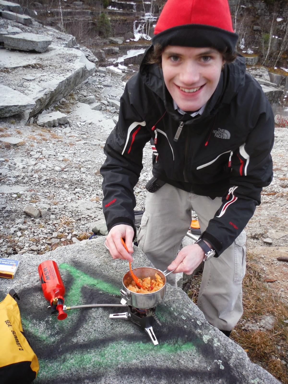
After trying it and getting almost the same chirp from each rock bounce, I was instantly addicted.  Rock after rock went onto the ice.  Ploing, ploing, ploing over and over again.  Meanwhile, the smarter one of us was starting up his stove to prepare a meal.

Eliot prepares the pasta meal of a lifetime.
Eventually I ate my thermos-full of lunch, and went right back to rock throwing.  It was such an enthralling sound, and I couldn't get sick of it!  I tried dropping them from the cliffs on the right shore, with increased results of course.  Then the rocks got bigger.  Then we broke the ice. The air from impact was stuck under the ice and started migrating under the surface to the highest point. After filming some slow motion rock impacts, Eliot took to harvesting ice with his ice ax, which from across the quarry, sounded just like the rock ploinging.  Can't say I've had much of a better time.  In honor of the ice, we hacked off a piece and posed with it:


Realizing that 4pm had come and gone, we decided that the easy way down (i.e. not buskwhacking) would be down the granite transport road I mentioned earlier.  I knew we could road walk this bit back to the car because I had been up that way in the summer before.  It was an excuse for us to test out our new headlamps, which performed with utmost excellence!  More geocaching is in our future...and some rock throwing of course.