Sunday, April 26, 2015

2015 Road Trip: Part 9 (Sangre de Cristos)

Sangre de Cristo Mountains, NM
Day 13
4.26.15

April 26th, day 13 of my trip, I woke to an interesting weather forecast. Snow.  Snow in New Mexico, on the eastern slopes of the Sangre de Cristo Mountains.  Timing was hard to figure out from an audio forecast, so I was living on the edge since the morning.  In Mills Canyon, I had some high cirrostratus clouds, which is typically a sign of some incoming storm.  The weather was still fair, so I planned my route during breakfast on the glorious picnic table.

I had no specific plan as far as an endpoint, but I certainly didn't want to go outside New Mexico, having experienced how long it took to get anywhere in the state yesterday.  In preparation for this trip, I had starred a few places in NM to see, one of which being Wheeler Peak, the highest point in the state.  Where I was currently, Wheeler Peak was only 150 miles away, though any chance of hiking it was shot with impending snow, as well as waking up too late to actually drive there, and have enough time to hike.  However, I still wanted to see it, so I decided on Bobcat Pass, which is a road that drives around the north side of the mountain.

With everything packed up, I proceeded to get a closer look at the canyon walls before leaving the site.  The ground was very soft, filled with cacti and pokey bushes.  Nevertheless, I made my way to the walls.

The view toward the west wall of the canyon
Holy walls.  (The power of Jesus?)
I was considering going a bit further up the wall where possible, but the rock was way more crumbly than expected, so that ended quickly, as I wanted to be able to get down without tumbling into a cactus-field. Instead, I took a closer look at some of the rocks.

Ultra holy walls.
After walking back to the campsite, I snapped this picture of the east canyon wall.  I love how fluid it looks.

East canyon wall
I was ready to leave the site and head up the 2-mile ascent up the rough road to the top, but I wanted to briefly check out some of the other dirt roads on the canyon basin.  Not more than 5 minutes in, I was going through some ruts, and a heard a horrible snap under the car.  Perfect. Glad to have AAA coverage.  I pulled past the rut to flat ground, since nothing was collapsed on the car, so I could look underneath.  The piece in the picture below was hanging by the rubber linkage on the right side, and I pulled out the tools to try and remove it since I didn't want it hanging down while I was driving.  That was a failure, since everything was all rusted together.  I determined that it wasn't a crucial piece to holding the wheel on, so I figured I better keep driving and see what happens.  Ten seconds later, the rubber linkage snapped too, so the piece was detached.  That is what I wanted, right?

My sway bar and where it ought to be...
Well, it turns out I made it out of the canyon, and 100 miles further, fine with no issues.  Thanks to the smart people on the Subaru Facebook group, I learned that this is my precious sway bar.  Its purpose is to control body roll while cornering at higher speeds.  Some cars have these and others don't.  Without it, I technically have a fully independent front suspension, which is ideal for off-roading since it provides a bit more flexibility for dealing with uneven terrain.  I consider it a favorable modification.  Wombat, welcome to Phase II of your life!

Urban New Mexico
I thought I lived in rural Maine.  Rural Maine is extremely developed compared to rural New Mexico.  There is nothing for miles and miles and miles.  Just straight roads.  Again, I passed through these "towns" that involved not much more than a crossroads, and a building or two if you're lucky.

Finally, I made it to a civilization that provided me with some petrol, for my thirsty tank.  I believe this was Springer, NM.  I continued west to challenge the Rocky Mountains with a full tank.  I was following scenic drives according to my atlas, with roads like Rt. 199, Rt. 21, and US-64. Somewhere along this stretch, I was driving along, looking in awe at the mountains that were rising up above me.

Then what I thought to be a gazelle tried to commit suicide via my car.  I saw all of this peripherally, so take it with a grain of salt.  I believe it was on the left side trying to cross the road, realized I was in the way, and decided to race me instead.  Mission aborted and pseudo-gazelle returned to the left side of the road.  I thought it was going to hit me, but we were both very lucky.  After a New Mexican mammal search, I deduced that it was either an oryx or a pronghorn antelope.  I believe it had straight horns, so I'm going with the oryx.  (Sorry no pics, was trying to win the race.)

US-64 west heading toward Wheeler Peak
The beautiful Sangre de Cristo Mountains began to rise around me as I moved west.  US-64 passes through Cimarron Canyon State Park, which is different from all the canyons I have seen so far.  This one appeared to be made of metamorphic rocks, where the rock is transformed from pre-existing rock via extreme temperature or pressure. These rocks often form vertical flumes and look like a fluid that got frozen in time, then chunks broke off.  I had to pull over to get a close look, since the walls were so high I couldn't see the top from inside the car.

Cimarron Canyon SP, north wall
During this part of the day, I was seeing some intermittent blue sky patches, though some of the roads were wet, indicating there had been some precipitation.  I wasn't sure where and when this snow was, but I was on the lookout.

I turned north onto Rt. 38, and started the climb up to Bobcat Pass, the highest mountain pass in the state of New Mexico.  This road was filled with tight twisties as well as some sweepers.  This was when I really began to notice the lack of engine power.  At sea level, the air is dense with oxygen, and you get the right air-fuel mixture, but up over 9000 feet, the air is less dense, and you end up with a gasping engine that needs to rev super high to have any power to climb the hills.  Once I got the Bobcat Pass, I got out to take the picture, and did so very quickly because the temperature up here was very cold (probably 40s or so, compared to 70s down in Mills Canyon).

Bobcat Pass!  9820' above sea level
Soon after going over the pass, I saw a gravel drive that went up a hillside, and I hoped that would have a better view of Wheeler Peak, the mountain I drove here to see.  I couldn't have been more satisfied.  This road climbed over 10,000', presumably a first for Wombat.  The snowcapped peak stood guard over the range, nearly luring me to come climb it.  Perhaps some other day.

Wheeler Peak, 13,159'
The descent from the pass began, with some dramatic views around every bend.  Unfortunately there were these concrete barriers everywhere.  Maybe you think they are beautiful.  In which case, you'll love this photo:

Stunning concrete barriers, with some irritating mountainside carved out behind.
I came down into the ski town of Red River, NM.  I pulled off here on a whim, since I saw a sign for the library, and we all know that's how Nathan gets internet along the trip.  It was a pretty town, and here is where I discovered all there is to know about sway bars.


Not long after, I heard some thunder, which was very exciting at this high elevation among the hills of giants.  It began to rain, and then it began to do something that wasn't rain, and also wasn't quite snow.  It was like small white balls of soft ice.  It became very heavy, extremely blowy outside, and covered everything with a layer of white.

"Snow" in Red River, NM
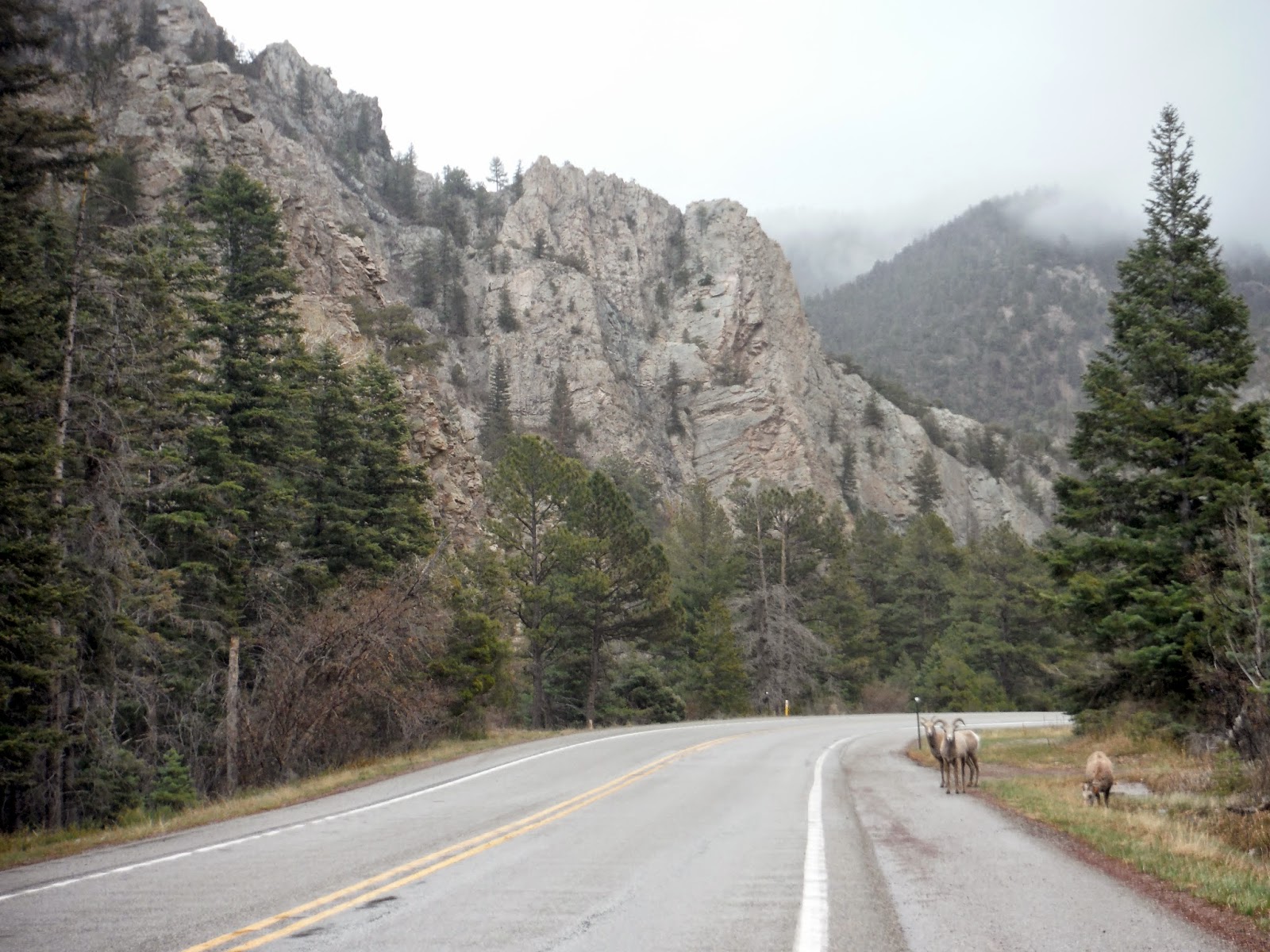
After it calmed down a bit, I continued down the road, and saw my first flock of bighorn sheep, calmly browsing along the edge of the road.


Bighorn sheep along Rt. 38
By here, I decided I should probably look for a place to aim for by evening, so I chose the highest state capital in the US: Santa Fe, at 7200 feet!  Relatively close, considering all the stops I had made just to enjoy the mountains.  While following some more mountain roads toward Santa Fe, I found a new road sign I haven't seen before:

Complete S-curve ahead.
While entering the general area of Santa Fe, I saw a fair amount of these awesomely decorated bridges.  I assume this is the outcome of the Native American culture that is so prevalent in NM.  Lots of cool art and stuff made from mud and stucco, etc.


Once in the city, I went to the ends of the Earth to find free parking.  For those in need, Otero St. has free parking for people on Sundays.  If it's 8am-6pm Mon-Sat, and you don't live on the street, you WILL be towed. Luckily this wasn't too far away from some nice streets downtown to walk along.  I decided I was going to check out places that serve you food instead of pulling out the camp stove and the coolers.  I found a neat place called Rooftop Pizzeria.  It was nice to settle down and not drive for awhile.

After dinner, I brought my car into the library parking lot for some catchup.  As you may recall, I wrote a few posts from that very parking lot.  I also debated for awhile where I would be camping for the night, and I chose a place that was only about 20 miles away.  What I didn't realize was that this place was deep into the mountains.  At 11,000 feet. Recall the forecast for snow?  Well if it was anywhere, it would certainly be there.  As I drove up the mountain, I got glimpses of the city lit up, which was truly a spectacular sight.  With as much incline as there was, and at this elevation, I was struggling to get the car to go any faster than 25mph.  Though that was acceptable since the radius of the turns around here was microscopic.

This place was supposed to be a ski area, but in the off season, you can camp there for free.  That would be assuming you can find the places to camp.  I arrived there in the dead of night, snow covering the mountainside, and half the parking lot.  I pull in, and wander around aimlessly again, like I did in Oklahoma.  It was in fact snowing here.  Perfect.  This is when I started to notice the effect of the elevation on my own breathing.  Normally walking across a parking lot is not challenging.  At 11k, I did notice myself out of breath.  That was a strange and exciting experience.

I found a place off the parking lot a bit, with a few inches of snow cover. I set up the tent and camping stuff, then turn my weather receiver on. "Sunday night, periods of heavy snow, accumulation around 5-10 inches, up to 15 locally."  This was not exactly what I had planned for.  I mean I could stay warm, but who knows if they plow the road up here in late April?  It would be a true test of Subaru AWD.  The only good news is that the winter storm warning was primarily for the eastern slopes of the mountains, and I was on the western slopes.  I went to grab the ice scraper from the car, so I would have it to use in the morning if need be.

I began to write in the journal, and of course the most comforting thing happened: a coyote frenzy that seemed way too close for anybody to want to be camping alone in a tent, 10 miles from civilization.  I'm not very easily scared, but this definitely increased the readout on my terror-ometer.  Luckily I did not get eaten that night.  Or if I did, I have been in a strangely realistic afterlife since then, and I'm also on a road trip across America.  And everyone I know is also in the afterlife?...

I set the alarm for 5am just in case there was 15" of snow.  Earlier would be better than later as far as escaping from the mountains successfully. We shall see in the next post what happened.  Also pictures.

EDIT: I always do this...I've forgotten to put the progress map in.  Miles to date: 3662.  Here y'all go:

260 miles of glorious mountain roads
EDIT: For those interested, this is what an oryx looks like:


Saturday, April 25, 2015

2015 Road Trip: Part 8 (OK-NM)

Oklahoma to New Mexico
Day 12
4.25.15

To make up for my damp morning the day before, I awoke to perfectly clear skies at Black Kettle Campground.  This was my view toward Dead Indian Lake:


I took a brief walk along the shoreline to fully experience the redness of the soil that is everywhere around here.  It is so strange when I am used to good old Maine soil that is brown and black and filled with clay.  This stuff is bright red, and very crumbly.

Shoreline rocks of Dead Indian Lake
Beavertail Cactus.  The dangers of the west are
starting to make themselves known.
While toasting some tasty blueberry bagels, I checked the weather forecast and things appeared to be relatively clear for most of the day.  I am one of those people that could listen to the NOAA forecast for way too long if I don't pay attention.  It's super handy to have a weather receiver for those times when I'm camping and internet forecasts aren't an option.   It also makes everything seem way more hardcore.

On my way from the campground back to I-40, which I arbitrarily chose as my route west, I was hopping along the road when I saw a huge collection of wind turbines off in the distance to the west.  I thought, well heck, I'm on a solo road trip, why not check them out.  So I ended up in a network perfectly straight roads that make up "blocks" that are 1 square mile.  All over I was seeing cows in these mile square pastures, and the wind turbines were getting closer.  With the predictable pattern of roads, I just drove in a direction that got me closer, and turned where necessary.

An example of the roads that make up the western Okla countryside
As I kept driving, more turbines would appear along the horizon, probably amounting to hundreds of them.

A cluster of turbines.
As I made it to I-40 again, I kept seeing turbines all along the highway for miles and miles, and my guess is that in total I saw over a thousand of them.  Never have I seen so many of them.  I assume that these turbines are powering the cattle ranches that cover this part of the countryside.

Now, I thought that Oklahoma was going to be flat, but what I really should have prepared for was Texas.  In Texas, the highways are set at 75mph, but so are the single lane state roads.  Everything is so expansive (at least in the TX panhandle where I was) that these high speeds make sense.  Initially I was dreading this part of the trip, since I love the twisty roads.  But there is something so vast about the emptiness and the hemispherical view you get that makes you feel so unrestricted.  If this picture doesn't capture it, I'm not sure what will.

Rt. 70 southbound near Clarendon, TX.
I had gone off the highway to find a pretty place to break for lunch.  The benefit to doing this is that I get to see some parts of the state that are away from the highway, and it breaks up the kind of driving that I'm doing.  If it was all highway, I would be bored quickly.  Even if it was all twisty mountain roads, I could get sick of that too, so it's important to keep it fresh.  My lunch spot was at Caprock Canyons State Park.  As I got closer, I was able to see the flatness give way to canyon rims.  Out of nowhere, this curvy section appeared as I wound through the canyons.

I had to pull over at this turnoff just to take it all in.  Canyons are something that rarely exist in the northeast.  Maybe we have a gorge or two, but something of this scale is unheard of in my home state.

Wombat lookin' happy as ever by the canyons
I was having fun too!
I found a nice picnic area that had tables with roofs over the top, I assume to keep the burning sun off pale scandinavian people who burn at the thought of sunlight.  After lunch, I made my way west along the state roads, through towns like Silverton and Tulia.  Some of these places were utterly depressing.  There would be a square mile or so of town block, but nearly every shop looked like no one was there for about 50 years.  Maybe a movie theater, or an old gas station, but not much was going on.  By the time I made it to Tulia, I saw a tractor shop with a Horsch overloader for grain harvesting, and being a Farming Sim fan, I had to stop and look at the real thing before my eyes.

Grain harvesters offload into these, and then when this is full,
it will offload into a semi-trailer which then goes off to the farm.
Tulia, TX was a bit more bustling, and had a highway connection via I-27, which took me up to Amarillo.  Along the way, I saw a sign for the town of Happy.  I'll tell you right now, the midwest has the funniest town names.  On the radio, I heard some stuff that was going on in Turkey, TX.  I mean, how far can this go?


Onward and westward, I entered the state of New Mexico, the land of enchantment.  After driving around in this state, I learned that that slogan is as accurate as you can get.  This was also my entry into Mount Daylight Time!


Soon after entering the state, I had to switch to state roads on my way to the next campsite in the Kiowa National Grassland.  I was headed to Mills Canyon, which I had read has a campground at the top, and if you have a capable enough vehicle, you can drive two miles into the canyon and camp there.  I bet you can guess which one I chose.

NM is also really flat.  It seems even more flat because there are no trees.
(The yellow stripe is from my solar charger sitting on the dash)

All the roads here are lined by cattle fencing, and you see sometimes a large crowd of cows, other times maybe only two or three, but there are cows everywhere.  They literally own all the land.  Even with a GPS, I've learned that planning out gas stops is very important in this part of the country.  "Nearest gas, 50 miles" is not uncommon.  And town is defined as such here in NM: two roads that cross, maybe a barn, and a truck if you're lucky.  It's funny to see these places listed on my atlas, and then you drive through, wondering where the "town" was.  I suppose that everything is so spread out in this area that they wanted to put at least a few towns in for aesthetic appeal on the map.

Canyon rims start to appear.
Near the place where I took the above picture, the road climbed up this to near 6000 feet.  It was pretty, though I wish I had been driving down so I could see it better.  I didn't stop for pictures because I wanted to make sure I had daylight to make it down to the campground, if the road was going to be notoriously bad.

I found the 9-mile gravel road to the upper campground.  There, I found a few people chilling by their RVs, and actually a horse trailer.  I encountered the horses on my way down to the lower campground, on their way back up after a ride down to the bottom of the canyon.  The road wasn't too horrible, though I went slow to avoid tire punctures with sharp rocks.  It was very pretty look down into the canyon along the way, and seeing the Canadian River winding through.


Off-roading Wombat once again!
Likely due to the difficulty of the road to the base, there were many open campsites.  I think there was only one other group of people there.  So I logically chose a spot that was close to the river and close to a bathroom.  There was a large cloud of dust behind me everywhere I drove, though the campsite roads were more gravely.  Once I parked, I saw on the back of my car a coating of fine red dust all over the back of the car.


Home for tonight!  A fire pit too!
Looking the opposite way, I had a sweet view of the canyon wall to the east.  Had it not been so late, I would have checked it out that night.  (I actually did the next morning, so I was able to get a close look at the rock structure.)


The elevation of the bottom of the canyon is near that of Mt. Katahdin in Maine, around 5300', and the walls rose to about 5800'.  It is so strange to imagine that a perfectly level line from this camp to Mt. Katahdin would match an elevation that rises 4000 feet from the surroundings of northern Maine.  This is all part of the slow and steady climb to the Rocky Mountains.  The midwest is flat, but it is ever increasing in elevation as you go west.  Check out this cool image I found that illustrates this very well.  It has the state boundaries so you can estimate roughly where I am.  Mills Canyon is about at the top of the red range in northeast NM.  You can see how through Oklahoma and Texas, there is a steady climb.


With a picnic table at my disposal, I decided to a) eat lots of food in a non-rushed environment, and b) break out my stash of Twizzlers.  They were delicious.  The sky was clearing from the slightly overcast it was before, and as darkness fell, the stars covered the sky.  Also, the waxing crescent moon came up above the canyon walls before long.  I made my best attempt at a campfire in the pit I was provided, but I had a fairly crucial problem, which is wood.  There were cedar trees around, but you're not supposed to cut those up...only dead wood, and all I could find that was dead was these bushes that almost looked like tumbleweed.  They were very dry, because I guess it hardly rains here, and they were small, so everything burned very quickly.  Because of this, the fire did not last terribly long, but it was fun to have it for awhile.


Having been camping for a few days already, I was beginning to have some loneliness symptoms, so I figured what better way to cure this than to pull out the accordion and play all the familiar tunes!  This was an experience in itself.  Playing under the night sky in a canyon with a rising moon is something I haven't ever done before, and it was very therapeutic.  In addition, it was nice to write down all the happenings of the day in the journal I've brought along.  I've done some digital journaling, but when Im camping, sitting down to write it all out by hand is much better.

This day was a bit shorter as far as mileage, but this was the idea, since I was entering the land of more interesting terrain.  I wanted to take more time to enjoy it without rushing.  Day 12 miles: 463.  Total miles to date: 3402.


Prepare yourselves for an interesting day coming up.  Make sure your tray tables and seat backs are in the upright position.  Seat belts would be useful too, since we're going up through the mountains tomorrow. Yeehaw!

Friday, April 24, 2015

2015 Road Trip: Part 7 (AR-OK)

Arkansas to Oklahoma
Day 11
4.24.15

Deep in the unknown of the south central region of the US, I awoke to the pitter patter of raindrops on my tent.  I slept in to try and catch up after my extended drive yesterday, but I was very interested to see the campsite in daylight.  It was wet, green, filled with bugs, and there was a very large spider on my tent (thankfully on the outside).

Wombat settled and ready for another day of travel (as always!)
I attempted to pack up the tent without getting it more wet than it already was.  That was mostly a failure, so in it went to the stuff sack as a sopping mess of nylon and netting.  I realized I hadn't taken any pictures of my packing system for the car, so as an excuse to stand under the hatch to stay dry, I took a picture of it.

Clockwise from bottom left: water jug, accordion, clothes, sleeping bag,
sleeping supplies, frisbee, food coolers, cooking supplies, and boots!
The car appears to be pretty full, but what's nice is that it's only one layer deep in most places, so I can access just about anything I need quickly. I admit it took me awhile to remember the location of everything, but by now, I've got it down like the back of my hand.

I found a covered area elsewhere in the campground where I could prepare some breakfast without getting drenched, so that was step one. Afterwards, I drove into town to search for a place to stay for the coming night.  The goal was Black Kettle National Grassland in western Oklahoma, 475 miles away.

Since I was in western Arkansas already, I entered Oklahoma pretty soon in the drive, though keep in mind I started in the afternoon since I didn't want to be driving on only 4 hours of sleep.  It was very rainy, and according to my portable weather receiver, I heard that there was even more severe T-storms and tornado watches in Louisiana.  Despite my wish to see a tornado while driving through the midwest, I was easily repelled by the thought of large hail wrecking my car.

Oklahoma greeted me with a sweet trailer full of tractors!  Impressive load, pulling 4 full size tractors, each with easily 100-150 horsepower. Happy to see a Kubota included.


The rain gave way to some partly cloudy skies once I arrived on I-40 westbound.  It was a relatively uneventful stretch of road, giving me some time to enjoy some music, and by music I mean Infected Mushroom.  They are the best band for making long stretches of highway go by like nothing.

One big surprise for me, was how NOT flat eastern Oklahoma was.  It was actually filled with rolling hills.  Every once in awhile I would get a long bit of straight road, but nothing crazy like what I would see in the coming days.

While passing though Okla City, I saw some radical older planes right near the highway, and I almost stopped to take pictures, but...as you noticed, there are none.  Instead, I pulled off the highway to find some place to cook dinner.  Like the day before, I was in favor of cooking dinner, then continuing driving for awhile to the campsite.  This allows one to more quickly pass through theoretically boring parts of the country.  I was very wrong about this assumption.

I found an unexpectedly neat place called Red Rock Canyon Sate Park for dinner, just outside Hinton, OK.  I was racing the sunset, hoping to arrive at the park before the sun dipped below the horizon.  I won, and got this picture as the prize.

Red Rock Canyon SP sunset

One of the great things about a trip like this is that you get to see the sun rise and set from so many different places.

I drove down into the canyon, and was surprised to see big chunks of red rock jutting out from the ground like this!

One of several large jutting rocks in the park
A shot of Wombat near the canyon wall

Panorama of the canyon wall
After selfishly taking some Wombat shots, I found a picnic table next to some other campers and pretended like I had reserved a spot.  It would have been great except for a guy with his big truck and a trail with an obnoxious generator running on it.  God knows what they were using it for, but thank you for ruining the camping experience for everyone around you.  Finally he pulled it away and shut off the generator, and only then was the smell of campfires able to permeate everything.  It's a smell I have missed.  Soon, I will be having some campfires.

After dinner, I began the last leg of the journey to the Black Kettle Nat'l. Grassland, 100 miles to the west.  This is almost one part of the trip I wish I had seen in the daylight, and for two reasons.  One, I would like to have compared the western part of the state to the eastern.  Two, I nearly went mad with how straight the back roads are in Oklahoma. Compared to these roads, I-40 was a twisting mountain road.  You turn onto the road, then you don't move the steering wheel for 20 miles.  But there are some rolling hills, and at night, this makes it seem like the road will end every time you crest a hill.  Thankfully they warn drivers of curves with many reflecty signs.  And if there is a stop sign somewhere, they are kind to drivers who zone out after many straight miles by putting rumble strips before the intersection to wake you up.

Eventually, I found this campground, though I felt very clueless wandering around the mishmash of roads at night.  I saw this one car parked (engine running) down at the boat ramp, with no people to speak of.  Keep in mind this is at 11pm.  Slightly confused.  I wandered for a bit with my headlamp to find a place to set up camp.  I found a place that wasn't too far from the parking lot, which is ideal when car camping. Who wants to carry stuff a long way?

Day 11 progress map.  Miles from the day: 475.  Total miles accumulated: 2939.  Nearly 3000, and there are still at least four large states before one can see the Pacific Ocean.  The United States is an expansive place.


Check out the next post for daylight pictures of Black Kettle grasslands!

Thursday, April 23, 2015

2015 Road Trip: Part 6 (Mammoth Caves)

Five States, Mammoth Caves, 800 miles
Day 10
4.23.15

Little did I know that today would be an extremely long day.  But filled with truly spectacular things, as well as some mediocre ones.  I began the day in Hoosier National Forest just south of Bloomington, IN, after my second night at the horse camp.  The Hickory Ridge fire tower was a few miles from the campsite down the gravel road, so I was looking forward to catching a sunrise from the top, being so close.  It took awhile to actually find it since signage is not great 'round these parts.  I pulled up to it, and it was the largest tower I've seen so far on the trip.  It was built in 1936, and was one of 8 towers in the Hoosier NF.  Now this is the only one remaining.  And for the first time ever, the cabin was open to the public!  Finally somewhere not so sketchy to stand to watch the sunrise.  It was very cold, compared to the 70s I had seen over the past few days, so I had to break out the hat and mittens for proper camera operation.

I was able to watch the sky go from a dark glow, to a bright pink and orange, to the sun finally breaking across the trees, and then fully emerging.  I'll just leave one picture so you can get a sense of it.

Sunrise from Hickory Ridge Fore Tower
As I was waiting for the sun to come up, two students from IU made their way up to view the sunrise as well.  It was nice to share the experience with them.  (If you two are following the blog, this is the post for you!)

I began the drive down to Mammoth Caves in Kentucky, which I have heard many great things about, but never had the chance to see.  I love this about my trip - I am able to actually go see things, instead of eternally wishing to go see them.  On my way south, I found my first dose of endlessly straight roads.  Ohio was flat and straight, but there were stoplights every so often.  But here, you can go for a long time without seeing an intersection.  I was initially dreading these parts of the trip, but they are freeing in a way.  The vastness of these roads and landscapes allows you to feel more open.

This openness ended abruptly with Louisville traffic.  The highway around this area is very interesting though, because it winds through the hills that make up this area of the "Appalachians" if you want to stretch that definition enough.

Welcome to Kentucky!
Soon, I was exiting the highway to go to Mammoth Caves!  I also realized that I had crossed over into Central Time, and because part of Kentucky is in Eastern, and part in Central, they label all the times for everything with the time zone.  This was kind of them for foreigners like myself.  I browsed the different tours you can do there to explore bits of the cave system, and decided to go on two, which allowed me to see around 3 miles total of underground awesomeness.  One thing to realize about this cave system, is there is nearly 400 miles of human-passable cave network that is all interconnected.  Meaning you could go underground, and go through 400 miles without seeing sunlight.

One drawback to the cave tours here is that they don't allow flash photography.  This is disappointing because everything comes out a bit shaky, but it also means that to actually get a good view of it, you have to go, and nothing compares to actually seeing it and being there.  I took my camera on a tour called Domes and Dripstones, led by a super cool dude named Bobby.  I liked this tour a lot because it was pretty narrow, and it was focused more on the geology of the cave.  Aside from the entrance and exits, the caves here are completely dry, which means that stalactites and stalagmites won't form.  The caves are dry because of a sandstone "roof" over the top, which shields the water from seeping through, and dissolving the limestone to create the stalactites.  Some caves don't have the sandstone layer on top, so those will form more interesting formations.  Instead, we got to see narrow channels, a few deep pits, and dripstone, which I'll explain in a moment.


The way these caves form is from above, where the land is riddled with tens of thousands of sinkholes.  These allow rainwater to enter below the sandstone.  From here, with lots of time, the water can dissolve pathways through the limestone, and these passageways eventually lead to the Green River.  This river has carved its way down through layers of earth over time, meaning that the water from the underground caves can drain into it as it gets lower.  We entered the cave in a sinkhole, then exited along a slope, where water would have at one point drained into the Green River.


Toward the end of this tour, we saw the "Frozen Niagara Falls".  It looks like a frozen waterfall, but it's all made from limestone which has solidified as water seeped out and deposited the limestone on the already existing seepage.  Bobby told us that it took roughly 100 years to create one inch of limestone thickness here.  This is what we call the dripstone.  We were allowed to have a look from the bottom of the "falls" which gave this sweet picture below:

Dripstone at Frozen Niagara Falls
 The way everything is lit in the cave accentuates all the features we saw, especially ones like this.  This is a dormant feature, so it no longer seeps, but the fins that hang down from the dripstone must have been over six feet long.

Here we see a little bit of seepage, where mini stalactites and stalagmites have formed.  (I remember the difference between these because stalaCtite are on the Ceiling, and stalGmites are on the Ground.)


I went on the Historic Tour, which was much larger, with passageways exceeding 30 feet in diameter.  Of course, I forgot my camera in the car for this one.  This allowed me to experience it more personally though, since it's easy to "miss the cave" has Bobby said, if you take too many pictures.

We saw a huge ancient saltpeter mine in a part of the cave called the Rotunda.  It looked like something out of Harry Potter to be honest - this huge dome area that was nearly a half an acre in size.  From there, we followed the pathways through Fat Man's Misery, where you have to duck, and the walkway is tightly bordered by rock.  This led to the the infamous Mammoth Dome, which now has a huge staircase going up from the bottom.  This dome is 192 feet tall, and there are channels into which you can peer down from the stairs.

The first tour was much nicer since we only had a small group of less than 20 or so, but I am glad to have done both tours, because I got to see both the narrow tight caves as well as the larger ones.  The large caves felt like a movie theater with the way that they've lit the pathway with amber lighting.  One amazing thing they did on the tours is to have us gather round, then turn off all the lights.  You can see NOTHING, not even after your eyes adjust.  There is no difference with your eyes open on closed.  You can hear nothing (assuming we were quite like we were supposed to be).  It was a surreal experience.  Bobby then turned on a dim LED and the cave looks very different this way compared to the standard lighting.  It makes me want to try spelunking, because this is what it looks like - just helmet lights.

After emerging into the outside world again, everyone's eyes hurting I'm sure, I had decided I wanted to drive into either Missouri or Arkansas by the end of the day.  I hadn't found a place I could camp for free yet, so I went to Central City, KY for some internet mooching, and a food resupply.  I was an adequate distance from Lake between the Lakes, in western KY, so I headed there where I would cook some dinner, and then continue after that until I became too tired.  Here is a glimpse of the setting sun (or its glow at least) on Kentucky Lake.  It was a great place to have some dinner.  Five stars.

Sunset glow over Kentucky Lake
From this point on, you might as well stop reading, because all that happened is I drove for another 7 hours from Kentucky, western Tennessee, through the south tip of Missouri, and then across most of Arkansas to this strange point on Lake Ouachita.  I stopped to fill up with gas, acquire some caffeine, and scrape bugs off my windshield.

After 814 miles, I finally arrived at this camp called Big Firs CG, where I didn't really see any firs.  Nor was there a flat place to set up a tent, so I took a place that was as flat as I could find.  It was 3:30am, and by the time I set up the tent, I had seen 24 hours, if you account for the time zone change.  Something about that is exciting on its own.

Below is my progress map for Day 10.  With 814 miles added to the total, I've driven 2464 miles so far.  (The map isn't perfectly accurate, I'm realizing.  I'm calculating mileage from the odometer.) Westward I go!