Thursday, October 8, 2015

Autumn Katahdin Sunrise (and Sentinel later on)

For those impatient: yes, I finally got a sunrise viewing from the summit of Katahdin.  Something I've wanted ever since working there on trail crew in 2014.  I tried earlier this year with my buddy Eliot, but unfortunately, we got covered in clouds along the Knife edge headed to Baxter Peak.

With sunrise scheduled for 6:46am, I estimated about 3 hours to get to the top.  I chose to ascend along the Hunt Trail from Katahdin Stream, which is the final 5.3 miles of the Appalachian Trail.  As 3:30am got closer, I saw the Moon starting to rise to the south of Katahdin's silhouette.  A cool arrangement of planets was to take place as the night progressed.  First the crescent moon, the Venus, Mars, and Jupiter, all in line behind the Moon.  I was excited to break tree line to be able to view this.

Having adopted a new addition for solo night hiking, the good old music player and headphones, I got all my gear together and started up the trail.  It was quite windy, even at low elevation, so it was anticipated that stronger winds would be present on the exposed tablelands.

The question of which trail is the easiest way up Katahdin is really quite silly, since they are all hard.  The Hunt Trail is no exception, and I found myself quite warm within the first mile up to Katahdin Stream Falls. Soon, the boulders got larger, and the wind howled through the trees, creaking and making me nervous of them perhaps falling over top of me.

As I approached the Gateway, about 3 miles in or so, the boulders get massive and tree line was broken.  It was here that the fleeces, wind shell, glove liners, and mittens all came out.  The winds out here were ferocious.  At several points, I was concerned that I ought not to be up on the ridge in this weather, since I was having trouble standing. Instead, I slowly pushed on, making sure to hold on the rocks with my hands as well.  I found a few spots between rocks where the wind was calm and I could eat some snacks and add layers.

From the Gateway to the entrance to the Tablelands was a spine a rocks, ideally hiked during the day, but also an interesting challenge at night.  I had the moonlight nearly in front of me as well, and that was very beautiful, especially with Venus rising below it.

On the Tablelands, the sky was just starting to lighten.  I was able to get a shot of the planetary arrangement (though Mars doesn't come through because it is too dim).

Jupiter, Venus, and the Moon from Katahdin Tablelands
The sky changes incredibly fast around this time.  The colors indicating sunrise were beginning to appear.  This gave me some anxiety as I was hoping very much that I could make the summit before the sun rose.  I was tired from a fast climb already, and the cold winds were not helping my situation.  Hands were best kept in pockets because more than a few seconds in the air even with mittens, and I was getting pretty cold.


Looking between the sky, the summit, and my watch, and thinking about my legs.  That was the last mile or so as I pushed up along the rock steps to the top.  I rounded a crest and saw the unmistakable cairn and A-frame sign that marks the summit.  I had beat the sun!  Just about 5 minutes early.


What I love about Katahdin is that it's a lone mountain in a nearly flat landscape.  You feel on top of the world.

Rime ice on the summit sign
There was a fair amount of rime up all surfaces up in the tablelands.  By Thoreau Spring, there was more ice than water, and rock hopping was brought to a new level of difficulty.


Knife Edge
I had rested my pack on a rock, only to notice that both water bottles had a nice layer of ice inside them.  I quickly banged them against a rock and went to take a drink before it all froze, and what did I see but a glint of sunlight reflected in my bottle.  As quickly as possible, I got the camera out.  The sun had come early...perhaps because I was a mile high, lending me a sneak peek of the sun.


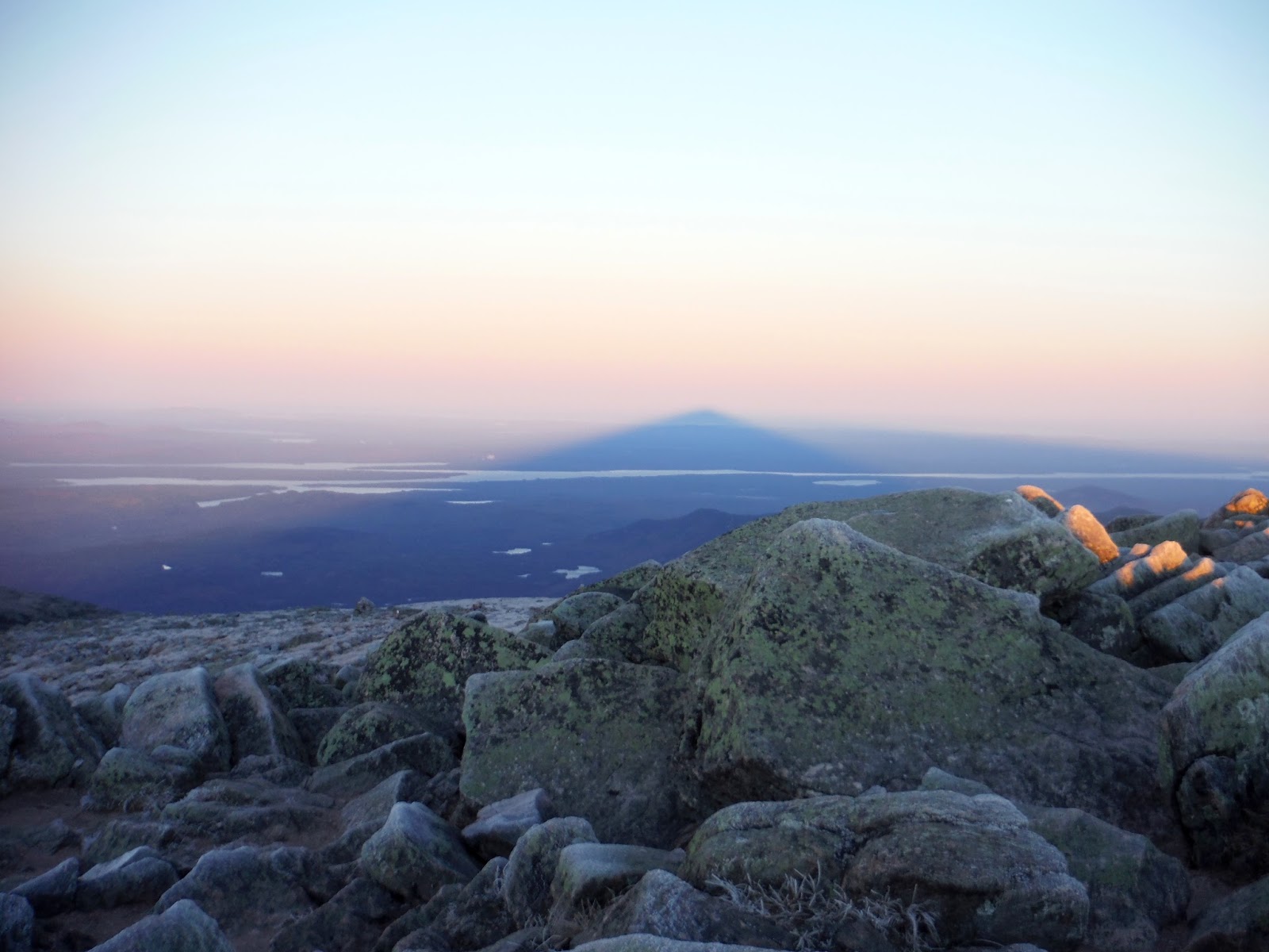
Now for the most exciting part for me.  I turned around to see the mountain shadow cast into the air opposite the sun.  I just learned how mountain shadows like these actually work.  I had seen pictures of them from Mt. Fuji or other large mountains, but what I didn't realize is that they are triangular not because of the mountain shape, but because the sun is a disk of light rather than a point source.  This causes the mountain shadow to taper off after a few hundred miles.  So this dark triangular shadow is actually a 3-dimensional tunnel-shaped void of unlit atmosphere.  The shape of the mountain would be cast at the end of the tunnel, but it is so small by then that it's rarely distinguishable.
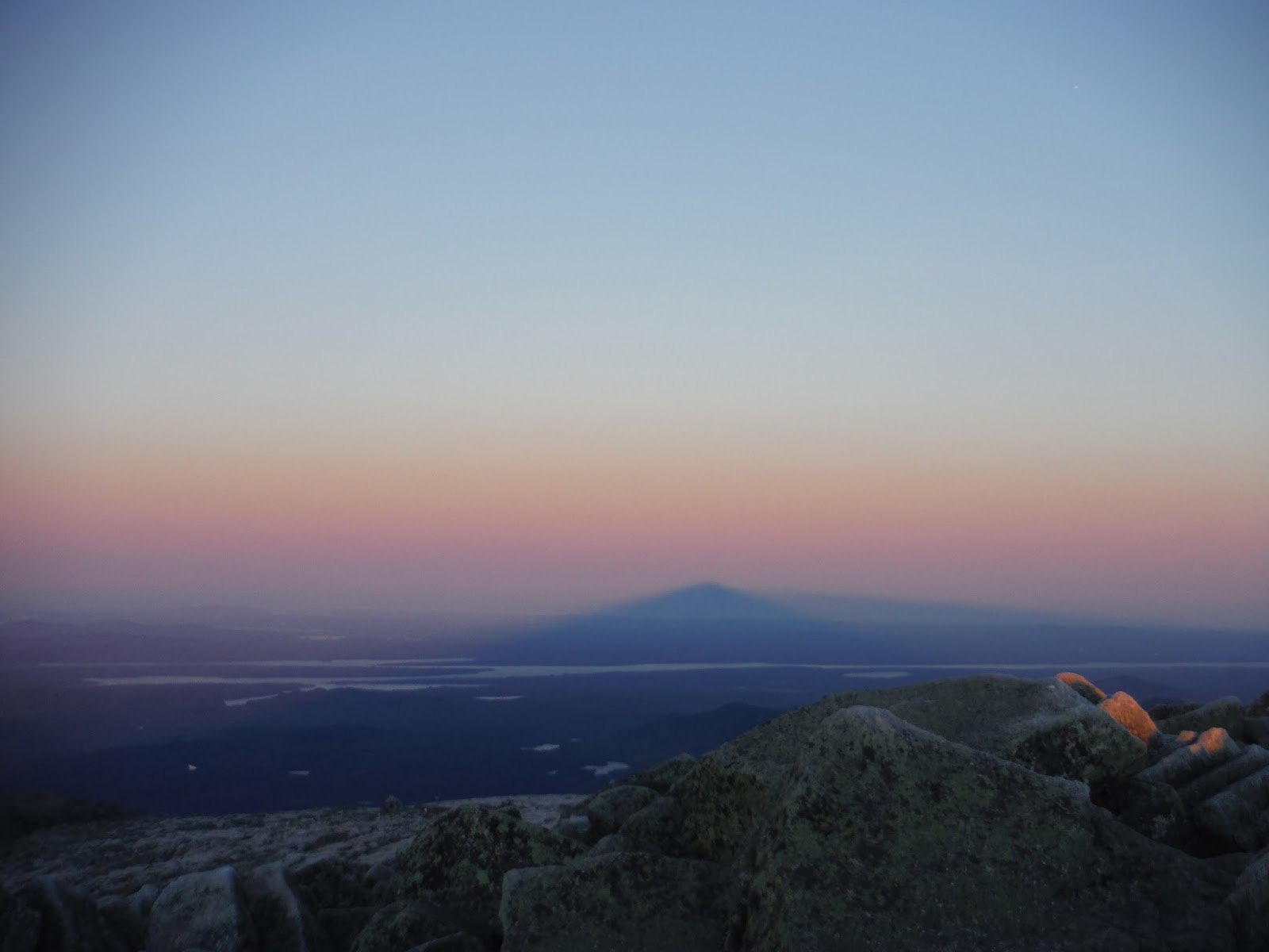
Mountain shadow
Below is the mountain shadow from further back.


Fire and ice.

Mountain shadow sinking onto the Earth's surface
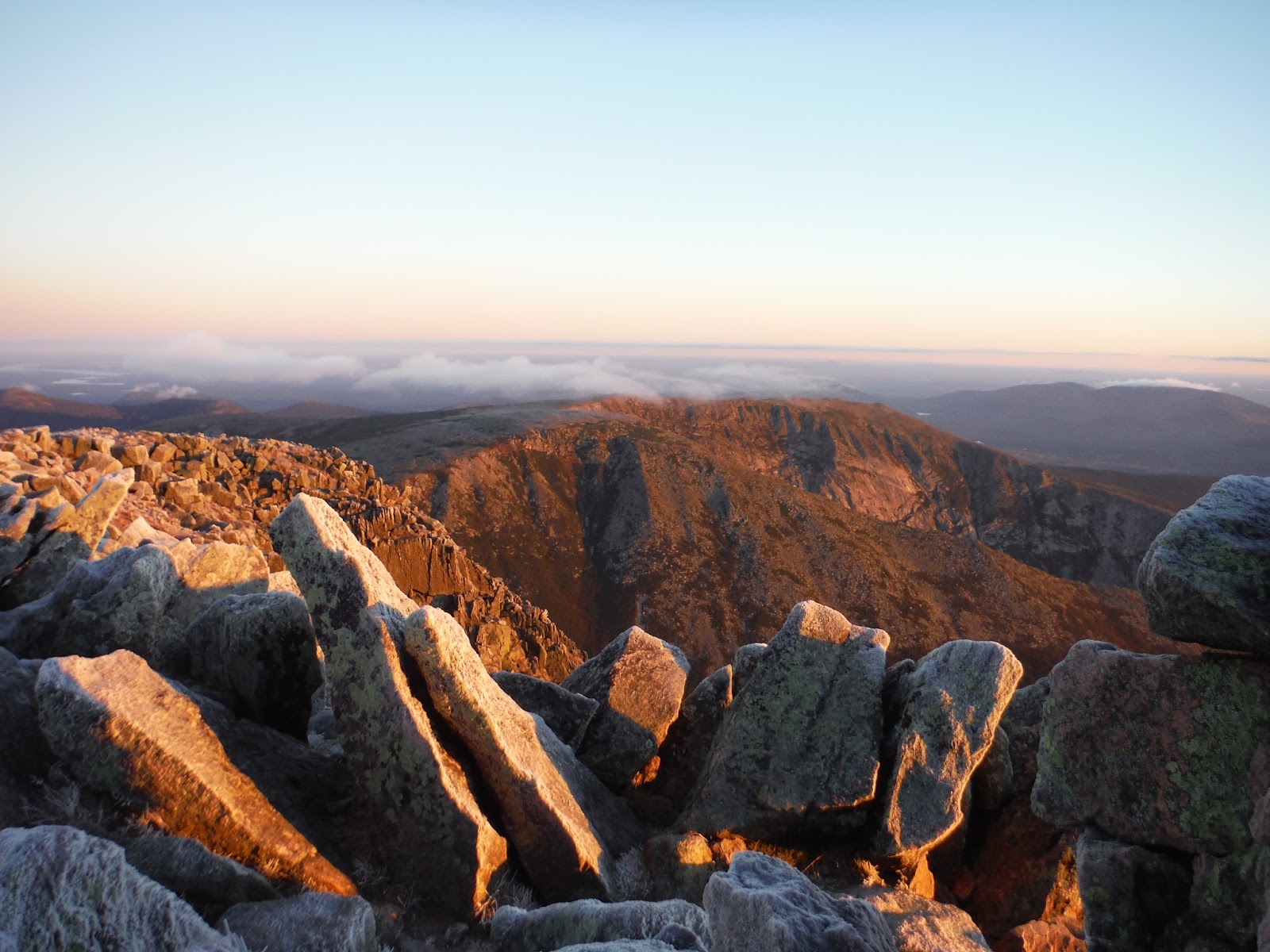
Morning light cast into the North and South Basins
After snacking on some food as fast as possible due to cold and wind, I decided to get one last look at the sun before heading down along the tablelands.  I was scheduled to meet my mom and her sister Becky at Daicey Pond for breakfast,  They had come up the day before and had spent the night in a cabin, and I  came in to join them for a day of hiking around the park.


Tablelands, laced with rime ice and sunlight.
It looks calm and peaceful.  No.  It was fierce winds that had me wrapped up in every layer I had with me: three fleeces, long underwear, wind shell jacket and pants, a hat, hood, and a balaclava.  I'm sure I looked quite silly, but that's okay since I was the only one up there. :)

Heading down to Thoreau Spring, I was able to photograph the ice that took my by surprise on the way up.  (Luckily no falls!)


At the edge of the tablelands, the Hunt trail descends sharply into the valley along the spine.


After descending the spine, this is the view back up.  It is stunning from every angle if you ask me.


The hike down was a breeze (no pun intended, despite the strong winds still beating at my hood and flapping about).  It was well below tree line when the layer came off again.  I saw over 20 people on their way up, and I hope for their sake that it warmed up a bit with the sun up on the top.

One mile from the trailhead, I stopped to visit Katahdin Stream Falls for a minute.  The roar of the crystal clear water was soothing.

Katahdin Stream Falls

Hike Data
Miles hiked: 10.6
Time elapsed: 5.7 hours
Total ascent: 4200'


Sentinel Hike

I joined my mom and my aunt Becky for breakfast at their cabin over at Daciey Pond.  (You may be shocked to realize that this was my first ever visit to Daicey Pond, even having worked in the park for 3 months.)  I had surprised them with the news that I had done a sunrise hike of K. But sometimes things are best done without prior knowledge (at least for some people).

We took a short drive over to Kidney Pond, where the Sentinel Mountain trail takes off.


This was a trail I had worked on for two weeks during my time on trail crew.  Below, I was showing my mom some of the steps we built.  The one she's standing on was a massive 400+ pounder that took four of us to move up the trail into place.  I have such an appreciation for rock steps on trails after having built some.


Heading up the steep section at the end, I ran ahead to take the picture. Inadvertently, it looks like my mom is picking up a huge yellow leaf.  (It's actually a normal yellow leaf, if you would believe it.)


From the scattered bald patches on top, we had a fantastic view of the mountains around, from Doubletop (seen below), and across the Nesowadnehunk Stream to OJI, Coe, Barren Mountain, and finally Katahdin to the far right.

Doubletop Mountain.  One of my favorite viewpoints in the park.
(I can't say the same about the trail itself though.)
Gazing out over the valley
Posing with the beloved K in the background
From Jackson's Landing along Kidney Pond, this was a familiar shot of K.  Every day was a little bit different, either with the fall colors changing or with the weather and the clouds doing their own thing every day.


Back at Daicey, the view from the cabins is much better than those at Kidney.  As the sun set behind Sentinel, we saw some alpenglow on K (which I was very much hoping to see and point out to my mom and Becky).  Alpenglow is just the pinkish or purple color that mountains will take on given certain conditions at sunset.  Very pretty phenomenon.  I have seen it a few time on K before, and once out in Moab, UT whilst tripping around with my pal Noah (Count Noah I should say).

Alpenglow
Hike Data
Miles Hiked: 6.0
Time elapsed: 5 hours
Total ascent: 760'

In closing, I have very happy that my aunt Becky got to spend such a nice time for her first visit to Baxter.  I am happy that I got to visit the park at the same time as my family, since that has never happened before.  My parents went up long before I was born, but never with me. It is a special place to me, since I worked hard for 3 months to keep the trail system alive and maintained.  I will forever respect it for its grandeur, beauty, and wildness.  "Forever wild." as Gov. Baxter would have said.

Sunday, September 27, 2015

Lunar Eclipse Hike at Ocean Lookout

I'd love to be able to share some wonderful pictures of the lunar eclipse on the night of September 27th, but instead you'll have to be fine with some "meh" photos.  It was a fun hike nonetheless.

I thought going to Camden Hills would be a fun place to watch the eclipse, specifically from Ocean Lookout, which has a good southeasterly view.

Before leaving my house, the moon had just started to rise.  Only a few hours now until the moon would move into the Earth's penumbra.


I had planned to hike up with Hunter (one of my Baxter friends for those who don't know) and Reid, meeting at the Mt. Battie trailhead on Rt. 1 at 8:30pm.  That would give enough time to hike up the 1.3 mile trail to Ocean Lookout, and still be able to view the eclipse.

As predicted, Reid was late, so I called him and said we'd be going up and for him to meet us up top.  I had only been up this trail in the winter before, and it does look quite different without any snow.  I was confused at several points, but we did eventually get to the top.  It is a surprising workout despite being a short trail.  You gain nearly a thousand feet over the 1.3 miles.

We looked through the trees toward the end of the trail, and noticed that the moon was indeed missing a small chunk from the side of it.  This meant hurry.  Hurry we did.  Soon, the trail flattened out and the beautiful granite ledges of Ocean Lookout were in sight.

Once settled on top, we discovered it was extremely windy.  I was happy to have all the extra layers I brought with me, sleeping bag included. The city lights of Camden were visible, as were the blinking lights of the wind turbines on Vinalhaven.

Camden at night
This is the only possibly good photo I managed from the event.  It shows that the moon did indeed have a chunk missing.  Reid did make it around this time to see the umbra passing over the moon.

Eclipse in progress
The most notable change besides the moon of course was the difference in star visibility from full moon to eclipsed moon.  Before the event, we were able to see maybe 10 or 20 stars, but with the moon in the umbra, there were thousands of stars visible, not to mention the Milky Way, which is always a great addition to the night sky.

Many cookies were had, and vuvuzelas were blown to announce to the world that the eclipse was in session.  I thought for sure that there would be others coming up to the same location to view the eclipse.  However, I was wrong, as we had the place to ourselves.

Google Earth track and elevation profile
Above is the Google Earth track and elevation profile.  It's not a terribly long hike, just 1.3 miles each way, but worthy to be included because it's such a nice destination.

The next total lunar eclipse will be on January 31st, 2018, so I consider myself lucky to have seen this one, since I can't remember when I last saw an eclipse.  The next supermoon lunar eclipse (is that a superlunar eclipse?) will be in 2033, quite a ways off still.  Happy sky-viewing until then.

Thursday, September 24, 2015

Presidential Traverse Northbound

In between catching up on sleep, catching up on food, and resting my legs, I am here writing about finally getting to do a hike I've had my mind set on for a few years now: a Presidential Traverse.  For those who don't know, that is a hike along the Presidential Range in the White Mountains of New Hampshire.  The traverse can be done a few ways, and with several options for start and end points.  The most important part is that you traverse the range, ideally hitting all the peaks along the way.

I did the hike northbound, from Crawford Notch along Rt. 302 near Twin Mountain, NH.  The mountains from the south are as follows: Webster, Jackson, Pierce, Eisenhower, Franklin, Monroe, Washington, Clay, Jefferson, Adams, and Madison.  I did not actually hike to the summit of Franklin and Clay however, because I didn't see Franklin on the map and I mistakenly took the "around" trail for Clay instead of the "over" trail.

My hiking plan was not at all to do a full traverse, but instead to hike out to Mt. Monroe and come back down along the Dry River Trail to where my car was parked.  I was not set on a traverse until quite a ways into the hike.  But before that, I'd like to enlighten you with my elaborate (not at all) planning skills.  I headed out driving west the night before, a bit after 9pm, planning to sleep the remainder of the night in my car and start bright and early to hit the sunrise for the first peak or so.  After a beautiful drive under the moonlight across into New Hampshire, I finally arrived in Crawford Notch, which was a new destination for me.

It was at this point that a small voice inside my head suggested that perhaps I could just begin hiking right from there, in the middle of the night.  And then I could have a shot at seeing the sunrise from Mt. Washington (not a bad thought there, is it?).  So it began.  I stuffed my face with some food and started across the road on the Webster Cliff Trail.

Here it begins...
I tried a new tactic for solo night hiking - I brought along my ipod for entertainment during the dark hours of the hike.  I figured this would increase productivity with no one to chat with.  I found it extremely effective, despite my liking for the sounds of the forest.

With Mount Washington lying 12.5 miles ahead of me, and 5 hours of darkness, I thought perhaps there was a chance I could catch the sunrise on the summit, if I stayed over 2.5 miles per hour.  That is a bit fast for very hilly terrain, but it's good to have goals right?

I took a few wrong turns on my way up Webster, potentially a bad thing in the dark, but I was able to find the good ole' white blazes again indicating the AT I was following.  There are a few viewpoints marked along the Webster Cliff trail that I would have liked to see in daylight. They were somewhat obvious due to large treeless granite patches.  I turned off the headlamp to gaze at the Milky Way and millions of other stars that were out.  The silhouettes of the mountain peaks were just visible after my eyes adjusted.

Mt. Webster, 3910'
I arrived at Webster in just under 2 hours, though I was not certain of it until I saw the trail junction just a bit down the other side of the peak.  On to Jackson, only a short jaunt with minimal elevation change.  The cedar bog bridging was making an appearance, and I was thankful as it is very easy walking on these.

Here was another ascending trail option I could have taken.  The Jackson Trail if I'm not mistaken, and it comes up to the col between Webster and Jackson.


I came to a slight clearing with some bog bridging and the winds started to pick up as I was mostly about 4000 feet at this point.  As you saw in my Webster summit picture, it was hat weather this time of night at elevation.

Bog bridging near Mt. Jackson, 4052'
Soon after Jackson is the Mizpah Hut, a very strange building to come to in the dead of night.  It looked larger than the Madison Hut in the northern Presidentials that I had seen earlier this year, but then again, things look different at night anyway.

Mizpah Hut
The cold started to seep into the air around here.  Rime ice was present here on the tips of the krumholtz needles.  You don't mess around with mountain weather on the shoulder of the hiking season.  I remember hiking Franconia Ridge last October and it was very wintery, rime, snow, and a cold brisk wind making it unpleasant for stationary activities.

Rime ice on the needles
I missed a picture of the Mt. Pierce summit, primarily because I didn't realize I had passed it.  (Again, no summit signs in New Hampshire...hint hint AMC trail crew.)  Mount Pierce stands at 4310', my second 4000 footer of the day.  Around here, I broke tree line and the winds really picked up, as did the clouds/fog.  I was worried that I was not going to be able to find the trail because of the think fog, but the trail was lined with rocks on either side, making things easier.

In the section between Pierce and Eisenhower, I first began to see the first light glowing to the east.  When you've been hiking for a number of hours in the dark, this is truly a magical experience.  Near to the sun at this time of year are three planets.  A conjunction like this is pretty neat, especially with an adventure happening partially at night.  Venus is visible at the top of the frame below, as it Jupiter, just above the cloud bank.  Mars is in there somewhere, though I doubt it came through with this much pre-dawn glow visible.

Pre-dawn glow, with Jupiter and Venus, 5:46 AM
It is staggering how quickly the sky changes around this time.  Only ten minutes later, and the sky is almost twice as bright.  Venus is still sticking around, even with this amount of light.

5:53 AM
6:04 AM
This is my prized morning shot of the day.  The tiers of mountains that lay to the east are visible here.  Life felt real.  There is something very immersive about witnessing a change like this happen.  Taking in large breaths of genuine mountain air as the sun comes around the corner of the Earth to greet you - nothing quite like it.

6:14 AM
6:29 AM
Because nature hates me with a passion, I got this for the sunrise.  Gosh darn clouds once again.  It got very cold and windy.  I got to Eisenhower summit, but my picture of it was crap, so you'll have to take my word for it.  Mt. Eisenhower is 4780' tall, the last of the sub-5000 peaks for the day.

Chilly on my way to Mt. Monroe, 5371'.
Due to the clouds and other mountains being in my way, I didn't see the sun until about an hour after official sunrise.  It made its appearance, and it was beautiful.

7:21 AM, the sun is visible!
The trail down from Mount Monroe is one of the most pretty trails I've seen in the Whites, in fact probably across the board hiking.  Easy to walk on?  Not so much.

Descending Mt. Monroe to Lakes of the Clouds Hut
At Lakes of the Clouds, I was actually given a view without too many clouds!  Below is Mt. Monroe, where you can really see the drop-off to the eastern side.

Lakes of the Clouds
I took a small break here and enjoyed the view.  The sun was high enough to reach into some of the more western White Mountains.

Me being peaceful, or maybe just avoiding being blinded.
I worked my way slowly up to the highest point of the day, Mount Washington, at 6288'.  The perspective of mountains as you rise and fall along a ridge is interesting.  From cols or saddles, mountains don't seem quite as large as they are.  About halfway up (or down) from a col to a summit, the one across the saddle looks menacingly large, especially if your legs are worn out.  If you are on the taller side (like the picture below), the smaller peak appears to diminish to much smaller than it is. Only 1000' shorter than Washington, Mt. Monroe appears minuscule, and I still have a fair climb ahead of me to the summit.

Mt.  Monroe behind me as I climb Washington.
My prize for the day was not having to wait in line at the summit of Washington.  In fact, I arrived at 8:50, before the park actually opens.  I was sitting down and munching as the park employees rumbled up in their silly SUVs.

Mt. Washington at 6288'.  My third summit of this mountain.
On Washington, I took a substantial break to eat, as well as to take a nap.  I went to the leeward side to escape the winds, and found a nice rock to stretch out on.  The sun's warmth was appreciated after a cold and windy trek along the ridge for a few miles.

I woke up a few times to people walking up the staircase speaking foreign languages, and it reminded me of how easy it is for people just to travel in from absolutely anywhere and drive up the mountain.  That's what I don't like about Washington.  A place like this is special, and I'll be honest, it ruins the experience for me a bit to see hoards of people up there.  Luckily, an early summit can avoid the worst of it.

The northern Presidentials: Clay, Jefferson, clouds, clouds, etc.
It was here that I made the choice to get my act together and do a FULL traverse of the Presidentials.  This was a hike I had been wanting to do for over two years, and I figured why should I wait for "the perfect time" to do it.  Now was perfect - I was here, and half of the mountains had been hiked already, with still three quarters of the day remaining.

I filled up my three water bottles and headed down the north slope of Washington toward Mt. Clay.  I stupidly made a wrong turn before Mt. Clay and went around it instead of over it, but I suppose my legs appreciated the slight break from up and down all the time.

Next up was Mt. Jefferson, standing at 5712', the third highest in the state.  I saw a few people here on the summit, and these were not far from the first people I had seen all day.  I saw one fellow going along a different trail around Lakes of the Clouds Hut, and then several around the summit of Washington.  I stopped here at Jefferson for a snack (carefully rationing out my remaining food, as it was around here I realized I didn't have as much as I would have liked), and thought long and hard about Mt. Adams and Madison, the two peaks I had left to complete my traverse.  Adams is a very large mountain, even from Jefferson, standing at nearly the same elevation.

Mt. Adams from Mt. Jefferson
Mt. Adams made for a very slow summit, as my body was starting take in the reality that I was attempting a 20+ mile hike on zero sleep from the night before.  With some musical motivation from my ipod again, I made it up to the the second to last peak.  I also met a south-bound AT hiker, Mountain Man, a nice guy to chat with.  Mountain Man had recently passed another hiker from Maine. and suggested that I might be able to snatch a ride back to my starting point with him, since he was parked at Jefferson Notch, planning an out-and-back to Jefferson, Adams, and Madison.  That solved my potential downfall to a traverse without having planned logistics for each end.

I had saved my last of three sandwiches for Adams, since I knew that was the last big push on the traverse.  It was amazing.  A small frog would have been amazing as well, but the sandwich was great.  As were the wheat thins.

Viewing Mt. Washington from Adams.
It is important to look both ahead of you and behind you on such a hike. The progress you've made is a powerful motivator in times of discouragement and tiredness.  Not to mention the utter beauty of a range like this.

Here is Mt. Madison, the last of the peaks on the traverse.

Mt. Madison, 5367' from the shoulder of Mt. Quincy Adams
(sub-peak of Adams)
I got to the Madison Hut (just visible in the photo above), and prepared myself for the last mountain of my traverse.  Both a very happy and sad concept.  It was absolutely spectacular to have spent the entire day in the mountains, mountains that I very much care for and would be sad to leave.  At the same time, my body, pleading for a rest, was happy to see the last peak in sight.

Looking back toward Washington and Adams, and all the mountains that lie behind those, it is a true look at the ruggedness of a hike like this. The rocks in the northern peaks are more demanding than the bog bridges and forest paths of the southern ones.

Washington (left) and Adams (right)
I made the summit of Madison, the final high point on the hike!  I know there is a whole mountain to go down, but I paused here to take in the view to the north, finally unobstructed by more peaks to conquer.


Descending along Watson Path, which would lead me to Appalachia, the northern terminus of the traverse, brought with it challenging terrain of sharp rocks and hard-to-find cairns.  I put on my mittens purely for protection from the rocks I was using as hand holds.  But soon, I found these funny things called trees!  I had forgotten about them after so many miles above the tree line.  They also make good hand holds for swinging down the steep terrain safely.


I saw a few people along this trail, eventually leading to Valley Way trail. I stopped at a stream crossing to refresh myself with some water. Knowing that I was only a few miles out from completion, I got myself up again to descend the last bit to Appalachia.  Perhaps due to too many hours awake, I ended up on Brookside Trail, which parallels Valley Way, and...you guessed it: follows the brook.

Just a few minutes after 16 hours elapsed time, I crossed the power lines that indicate the end in just steps away.  The evening light was passing through the corridor as the sun was on its way over the horizon, having done its work for the day.

Appalachia only a few steps away...
At the parking lot, I met a cool dude waiting to ascend the Airline trail for a night hike that evening.  A seasoned hiker and backpacker he was, and we talked about his experience in SAR and thru-hiking on the AT. And because I feel I should tell you, he very much recommends Sealskinz gloves for winter hikes - fully waterproof and windproof.  I tried them on, and they super easy to slip on.

I added up the mileage of the day as I waited for my ride from Andy, the friendly hiker of Jefferson, Adams, and Madison.  The total on the map came out to 24.2 miles, which, if correct, would break my previous record of 21 miles in Canyonlands NP with the one and only Noah Pappano.

Here is an annotated elevation profile from caltopo.com (Caltopo is an online database of the USGS maps, completely open-source and searchable like google maps.)


Hike Data
Miles hiked: 24.2
Time elapsed: 16.1 hours
Total ascent: 8920'

This brings my hiking total for the year up to 300 miles since January 1, 2015.  Hopefully many more before the year is out.  If you're wondering how exactly I made it back home, it was a long a painful journey involving a car-nap and some caffeine.  Totally worth it for a Presi Traverse though.  What to do next though???

Wednesday, September 16, 2015

Equinox Mountain (almost on the fall equinox)

My second adventure hiking in Vermont consisted of a trip to Equinox Mountain, a peak in the southern Green Mountains known for its good views, being made of marble rather than granite, and also (regrettably) a toll road to the top.  I have mixed feelings about roads up mountains. Nathan the hiker really hates getting to a summit and seeing a road approaching the top, however Nathan the driver very much enjoys driving up mountains.  So I suppose it comes down to me feeling guilty about my own interests.  Nevertheless, we embarked on the journey up to 3,840 feet above sea level.  The trail takes off from Manchester, VT, which is littered with coffee shops, roundabouts, and nice old Range Rovers with numerous bumper stickers.

Because safety is ALWAYS the first concern (especially hiking with Aurora), I expressed that in our pre-hike photo.


After some time meandering up the wide rocky path known as the Blue Summit Trail, we found a stand of birches that we have seen in a photo while researching the hike.  We put our own spin on the photo, using it as a frame for some portraits.

This is Aurora.  Invigorated by the idea of...something
This is Nathan.  In standard position
The trail began to ascend more steeply.  Water was drunk.   It was hot. There was shade, which mildly helped the predicament.  And then there was a bench.  Benches are known in urban areas for doing skateboard tricks on, or perhaps leaving an old paper bag with bits of bagels inside for the next person to never want to touch.  Here, we use benches for sitting and taking resting breaks.


Following the bench fiasco, the trail narrowed to a single file width, and we passed a man coming down clothed in denim, a fine choice for 80° days if you ask me.  He discussed having lost a hat further up the trail, and to leave it there on the trail as he would be back up soon to retrieve it.  We (read Aurora) saw the described hat and hung it on a branch, being careful not to come in contact with it for confidentiality purposes.

After entering the third type of forest of the day, the spruce-fir mixture that usually exists over 3000 feet, we came to a sign indicating a junction.  Left to the summit, and right to Lookout Rock, which we intended to use as the lunch eating location.  I photobombed, because that's what I'm good at.


Soon after, we found the top of the mountain!  The parking area was lined with some well-done marble stonework.


Atop the upper porch of the visitor center, there is a sign indicating what exactly we were looking at along the horizon.


Below, the view of Stratton Mountain, the highest mountain in the southern Green Mountains.  Equinox comes in second for elevation.


Panorama, credit to Aurora and fancy phone technology
We saw a unique and personalized Bronco which warranted closer inspection due to extreme coolness.

Bronco.  Ford, please bring back this model.  Please.
The view south (I think).  Mt. Greylock in Massachusetts is in there somewhere if I'm not mistaken.


The town of Manchester, VT
When the opportunity arises, always make funny faces.


We went out to the Lookout Rock to find a place to sit down for lunch. We ended up in a pile of sticks and moderate moss coverage because someone was using the proper lookout area.  Don't get me wrong, it was a NICE pile of sticks, so it's not like we got the short straw at all.  I consider it a privilege.

Before departure, we stopped again at the proper lookout to gaze at the valley once more.


The descent was pretty quick compared to the way up (as expected). There were no injuries.  Congrats to Aurora for making it through another day on Earth.

Google Earth track and elevation profile are below.  The mileage is always an uncertainty, but my guess is somewhere in the 6 mile range. The one-way length of the Blue Summit Trail is 3.1 miles, however we joined the trail in a short distance from the Red Gate.

Google Earth track and elevation profile
Total elapsed time was 5.5 hours, though there was some significant breaking at the top and at Lookout Rock, perhaps an hour or more. Can't say I was intently watching the clock whilst munching on tortellini.

Hike Data
Miles hiked: 6.0
Time elapsed: 5.5 hours
Total ascent: 2900'