I celebrated Thanksgiving (well, the day before if we're being picky) by searching out some snowy mountains to hike with my cousin Kristen. Luckily, we were able to find a free day in common to hike together. (It can be tricky working weekends...)
The verdict was Mt. Monroe via the Ammonoosuc Trail. Neither of us had been up that way before, so all was new and exciting. I left my house at 4 in the morning to try and get a good start on the hike. This is a wintertime 4am, where it's dark for a number of hours still.
I made it to western Maine before the dawn started to peek over the horizon behind me. I stopped to take a picture. The color spectrum in the morning really is one of my favorite things.
 |
| The morning glow in western Maine |
I arrived only a few minutes late to the trailhead for the Ammonoosuc Trail. I had come down Jefferson Notch road, which was thankfully still open, cutting off significant mileage from my commute. It was here I got my first taste of snow from last night's storm. Just an inch or so, but enough to make everything white.
Soon enough, Kristen arrived and we got our layers on. I feel like this ought to be called onioning. Getting all your winter layers on like an onion right?
 |
| Just a bit into the trail |
As the trail follows the stream, we passed some views into the Ammonoosuc Ravine, where the high parts of the mountain were clouded over. Soon, we found lots of ice where there are normally rock steps. Time for micro-spikes.
 |
| Kristen on the ice |
It just got icier and icier as we climbed. Rime started to form on the trees. Rime is one of the most beautiful things in the mountains. And extremely fragile as well. Just a quick puff of air, and it can fall off. But it stays on with the howling winds of the high hills somehow.
 |
| Icy ledges (trail goes to the right thankfully). |
More ice negotiation, and we found ourselves approaching the col between Monroe and Washington. The home of Lakes of the Clouds Hut.
 |
| Our first view of Mt. Monroe |
 |
| Lakes of the Clouds Hut, all locked up for the winter |
It was 0.4 miles from here to the summit, and it was eerily calm on this ascent. Normally, I expect to be tortured with 60 mph winds up here, especially this time of year. But no, it was mostly calm.
 |
| Kristen's photo of us from Mt. Monroe |
Not much in for views today, but hey, I got my snow fix, so that counts for something. We headed to the Hut again, where I hoped to be able to convince Kristen to join me to summit Mt. Washington as well. I was unsuccessful. We agreed to turn on phones as a safety, and we split ways, me heading up to the summit of New Hampshire, and she going back to the trailhead.
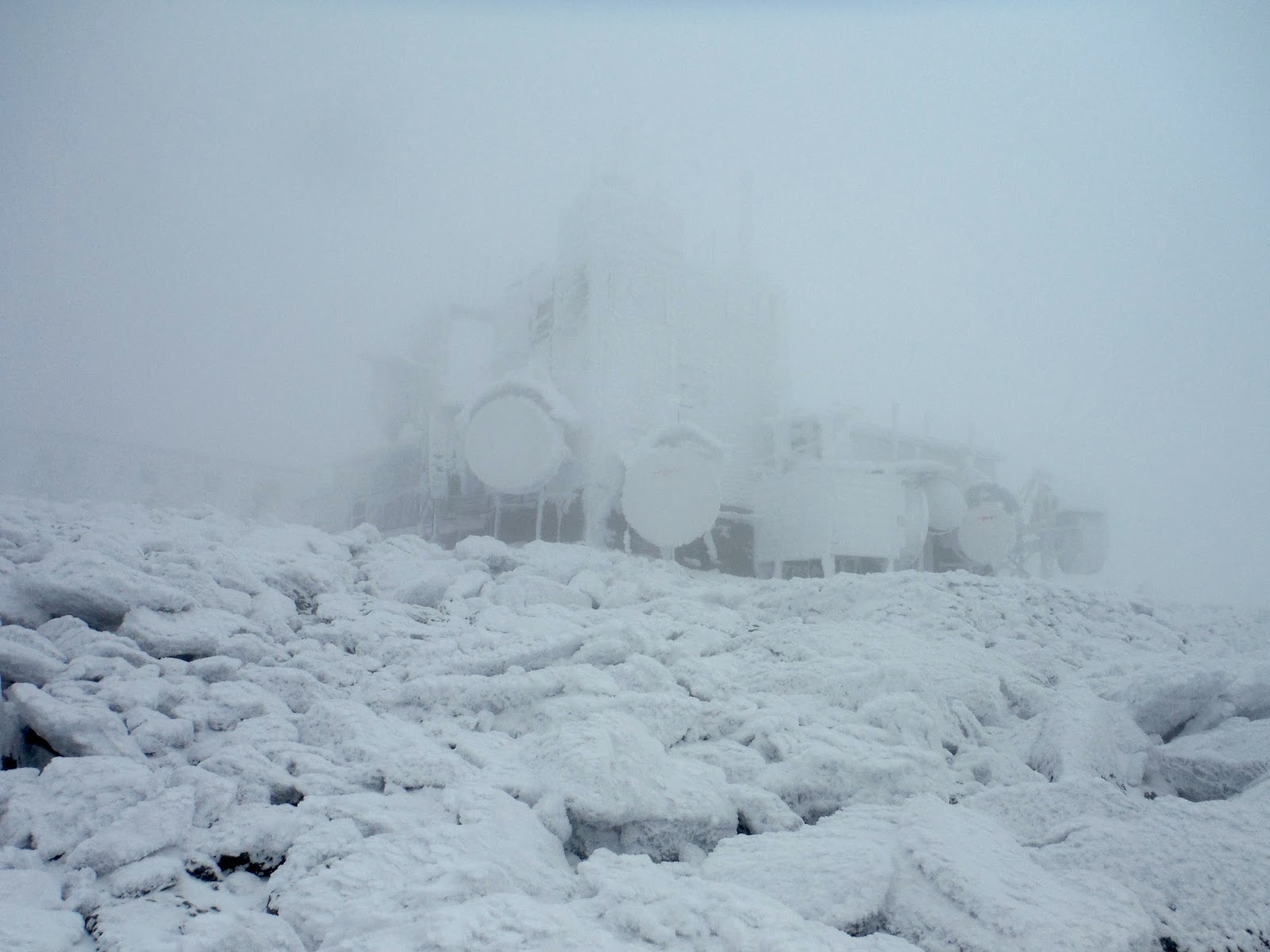
I was hoping for, but not expecting views from Mt. Washington. It was rime-covered for most of the trail up, with some icy patches, but no issues with the micro-spikes. After a relatively slow 1.4 miles, I saw the weather station buildings materialize into view. Quite spooky, and looking like the dead of winter, not a mere dusting from November.
 |
| Mt. Washington weather station |
 |
| 'Bout 8" of rime if y'ask me |
Some friendly hikers from the area agreed to get my picture at the top. It was uncomfortably windy at this point, so I spent a very short amount of time up here.
 |
| Yay! |
As per usual, it started to clear as I descended.
 |
| Ice patches on the trail to Mt. Washington |
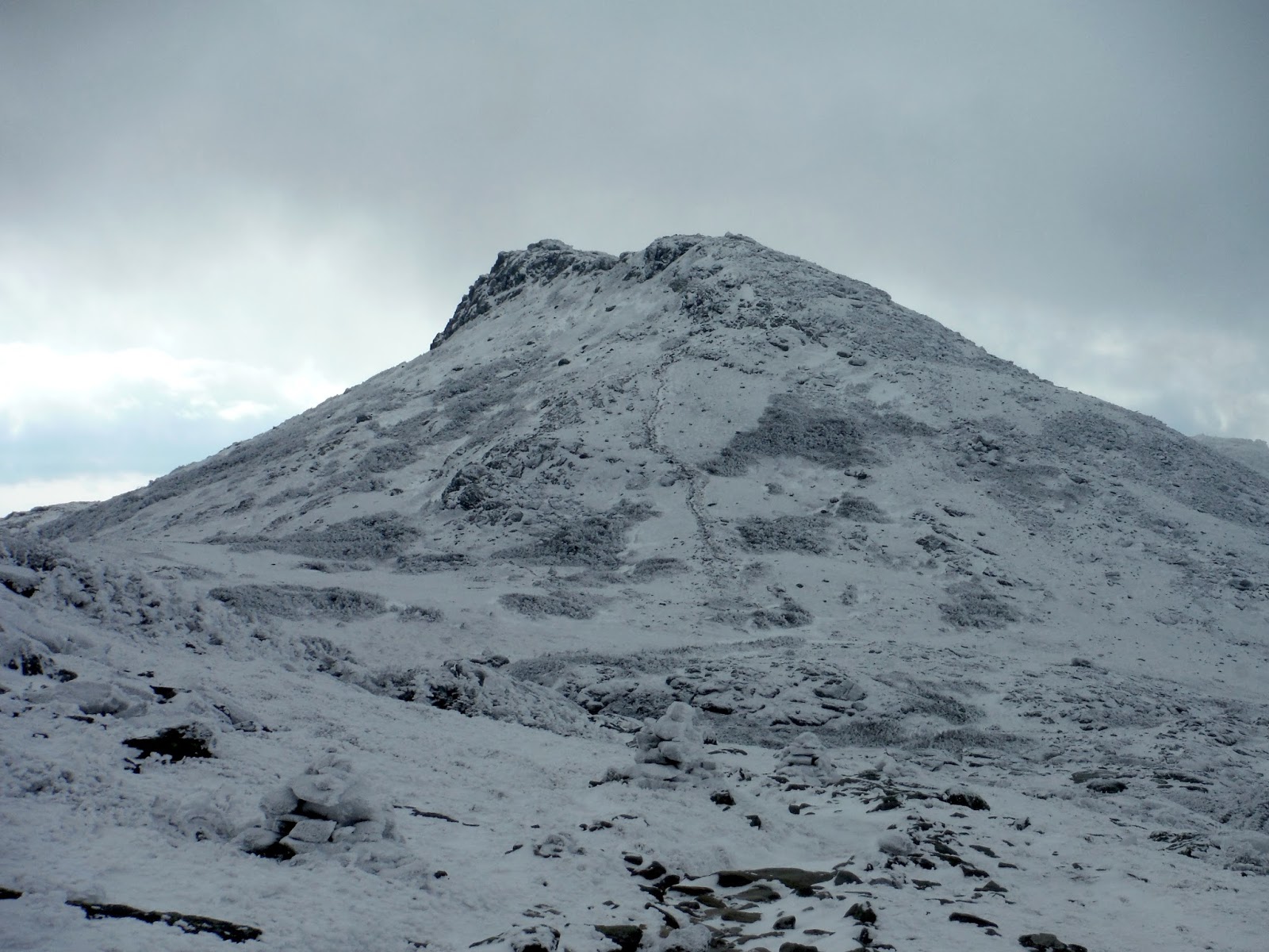
I could see all the way to Mt. Monroe and down to Lakes of the Clouds Hut as I worked my way down. Still pretty calm around here.
 |
| Mt. Monroe |
The icy trail past the Hut was truly a scary experience on the way down. I was wishing I had crampons and an axe the whole time until I was back on bare rock. But I made due with the micro-spikes. I received a call from Kristen as I was around the ice waterfall that she had descended completely without issue.
I got low enough in elevation that the ice wasn't everywhere, and I got rid of the spikes (hoping to remember that I took them off). You get used to having traction on ice, and then suddenly you are back to rubber - it can be easy to misstep on some ice and then you are done for.
I took the alternative trail out to the Cog Railway station, and I'm so glad I did. Skies had cleared, and the White Mountains were indeed white, contrasted by the blue sky and the green pines and firs from lower elevation.
 |
| Mt. Monroe over the railway station |
Walking a bit further downhill, the rest of the mountains came into view, from Mt Jefferson all the way to Eisenhower or perhaps Pierce...I'm not 100% on that.
Driving out on the north side of the range, I got to see Mt. Adams in the evening light. These mountains grab you by the eyes and make you look at them. At least for me they do. I just wanted to spend the rest of the day there.
 |
| Mt. Adams |
Here is the day's trip as shown by Google Earth. The map shows 9.2 miles, which I trust a little more than my hack-job tracing on Earth.
Hike Details
Miles hiked: 9.2
Time elapsed: 6.6 hours
Total ascent: 4220'


No comments:
Post a Comment