Thursday, April 30, 2015

2015 Road Trip: Part 12 (Cathedral Rock)

Yavapai Vista Tr. + Cathedral Rock
Sedona, AZ
Day 17
4.30.15

After arriving in Flagstaff and taking a day off after driving for nearly a week, Noah suggested that we go hike in Sedona, AZ to explore the area before our rim-to-rim-to-rim Grand Canyon hike coming up.  As per usual, I pulled up some hikes near Sedona to see what sounded interesting, and Cathedral Rock was something that neither of us had been to before.  Noah had hiked near it before, but never gone to it. This was the perfect choice.

Since a large album of photos was already uploaded to facebook, I feel it's a bit redundant to do the same here, so if you're interested, I've linked to the album here.  I'll just put up a few highlights here on the blog.

Towers at Cathedral Rock 
Picture of us climbing amongst the towers 
Me chilling on a tower 
Flowers we saw on the way down.
After our hike, we prepared for the Grand Canyon, which started the next day, May 1st.  This meant lots of gear shuffling and a trip to town to get some light-weight food to supplement our extremely heavy batch of banana bread we intended to take with us.

Tuesday, April 28, 2015

2015 Road Trip: Part 11 (NM-AZ)

New Mexico to Arizona
Cerro Quemado
Day 15
4.28.15

I spent 3 nights in New Mexico, and even after seeing some of the most amazing things on my trip so far, I felt ready to leave and head further into Arizona.  I had been booked to hike with Noah in the Grand Canyon for three days from May 1-3, and I wanted to arrive early enough in Flagstaff to go over our gear, possibly go on some smaller hikes before hitting the real thing.  Going all the way today would give me two days of prep time, which would be perfect.

Within 60 miles or so, I had reached the Arizona border, which I was excited about to say the least.  After hundreds of miles of flat New Mexico, I was ready for something new.  And surprisingly, not far after the border, the landscape did change!

Entering my 15th state along the trip.
I started to see more trees, more hills, and I entered the region of the White Mountains.  These are the White Mountains of Arizona, not anything like those of New Hampshire.  These are more like mini volcanos that are covered in a light grass.

If you know me well, you know what happened when I saw one with a road going to it.

Cerro Quemado, or what I believe to mean "burnt hill"
The road was pretty straightforward to begin with, though a few places were rutted out.

About 2/3 of the way up.  Summit "road" on the right.
As I made it past a cinder pit of sorts, the road began to wrap around to the back side, and then I saw the road that went up, up, and up to the top.  Around here, I saw a small herd of bighorn sheep, but they were running very fast and I couldn't get a picture.  It was nice to see some more of them after NM.  Let's just say it was terrifying going up something as steep as this hill/mountain.  Things began to slide to the back of the car, and I almost got caught in a rut, but I was able to find a way out using the power of AWD and my right foot.

Summit of Cerro Quemado, 8087'
No pictures on the way up because I was focusing on not getting stuck. But I got lovely views once I arrived on the top.


After taking it all in for a few minutes, I faced the fact that I had to get the car down that steep hill again.  Time to downshift.  Even so, I had to creep down ever so slowly to avoid punctures on sharp rocks.  There is not much that's thrilling like this kind of driving is.  For reference, I did calculate the slope of this steep part, and it came out to a 1:3 gradient, a 33% grade, or an 18.5° slope.  You typically see signs for a steep slope if the grade exceeds 6-8%.  This is a whole new kind of steep, but very fun to test out Wombat's capability.

Heading down, looking north
And here is my view of the "road" down the hill.  I had to go off to the side because I didn't have enough clearance for the standard ruts.  The surface is made of small pebbles that without any grass cover, just slide over each other, resulting in very low traction.

The view down.
We both made it down successfully, and kept heading west on US-60 into Show Low, AZ, among other strange place names.  Since I require myself to eat lunch at someplace that is at least somewhat pretty, I chose Tonto Natural Bridge SP, which was a few hours further west, but mostly along the way to Flagstaff, where I was headed to meet Noah.


I arrived and was not excited to pay an entrance fee of $5, but after seeing the park, I would have gladly paid $10 or more since this place is a hidden gem in the National Forests of Arizona.

View from one of the upper viewpoints they have.
I was bored walking from viewpoint to viewpoint on a paved path, so I decided to get gnarly and hike down into the gorge.  There was a warning board 3 feet tall of how the trails down into the gorge were extremely dangerous, uneven, and slippery with crushed rock.  Well this trail would have been considered a boulevard in Maine.  There were wooden steps, no roots to trip on, and occasionally a bench.  Apparently, dangerous is relative.

There were many different kinds of rocks down below, though many of them were polished very smooth from all the traffic that passes along the path.


I was grateful to have visited Mammoth Caves prior to this, since I was able to understand a bit more about the formation of this archway using that knowledge.  In the picture below, you can see bits of dripstone, forming fins along the limestone wall.


What I was staggered by was the size of this archway.  From the top, it looks a bit understated, but once you go down and stand in the entrance to it, you see that it is probably 150-200 feet tall inside, depending on where exactly you stand.


A stream runs through the arch, creating deep pools that they warn you not to swim in.  You still get quite wet while crossing from one side to the other because unlike Mammoth Caves, this arch does not have a sandstone "roof" on top to seal out the water.  This results in lots of dripping, holes, and some small stalactites.  There were birds nesting in several of the holes near the top.  And to top it off, the far side of the arch had a beautiful waterfall coming off the top.  I was torn between posting a picture from this side or from inside the arch, because they are both pretty cool I think, but I thought this was a slightly nicer shot.


I continued west along Rt. 260 into Cape Verde, which brought me to I-17 northbound, and then Flagstaff!  Flagstaff is cool for lots of reasons, but here's a few:

  • It was the first International Dark Sky City
  • Pluto was discovered here at Lowell Observatory
  • The Grand Canyon is only 80 miles away
  • Humphrey's Peak (12633), AZ's highest point is only 14 miles away
  • Everyone I've met here absolutely loves the outdoors
Since I've been staying with Noah, I have realized that the view along the road is one of the best you could probably ask for.  This is the view north to the San Francisco Peaks, the tallest of which is Humphrey's Peak.


San Francisco Peaks
The last leg of my journey to Arizona is 346 miles, which brings to total up to 4482 miles.  I consider this section to be Leg 1 of my Road Trip, since I planned to spend a longer amount of time here, exploring the area with Flagstaff as my home base.


I've been doing a few things around and about near Flagstaff since my arrival, so in the next few posts, I will try and be inclusive for those of you not coming from facebook, but also not repetitive for those of you that are coming from facebook.

I hope you're still enjoying reading about the trip as much as I'm enjoying it in reality (and also writing about it).  Cheers for now.

Monday, April 27, 2015

2015 Road Trip: Part 10 (De-Na-Zin/Bisti)

De-Na-Zin/Bisti Wilderness, NM
Crossing the Continental Divide
Day 14
4.27.15

As promised, I woke up early in hopes of avoiding being completely buried by several feet of snow.  I was lucky, however, because only a few inches fell during the night.  It was my first time camping in my tent in the snow, and it was pretty neat to wake up with some white stuff all over the orange of the tent.  Every once in awhile, a chunk of snow would fall off the side and I kept overreacting, thinking it was a bear licking my tent or something.

I'll be honest, I thought it was super cool waking up to snow (once knowing that it was totally drivable).  It's great to have variety along a trip, and this was the first time I had seen snow since hiking Camels Hump in VT, over two weeks prior.

Wombat all gnarly and excited to tackle the mountain descent
The road was super pretty in daylight - that's one perk to coming in late at night - you always have a surprise waiting in the morning.  Then again it's not terribly fun wandering around in the dark looking in all the wrong places for a tent site.

Rt. 475 heading into Santa Fe
So this was my second full day in the state of New Mexico.  About now, I started to realize how vast the western states really are.  I can't even imagine the idea of driving along the California coast, which is a staggering 840 miles long.  I haven't even managed quite that much in one day on the trip so far.

Slowly but surely, I was making my way across NM, though I hardly chose a direct route.  I came back into town to catch some internet to find places to check out during the day.  One place I had starred online was the De-Na-Zin/Bisti Wilderness Area, which is in the northwest corner of the state, near Bloomfield.  While reading up on the area on the BLM website, I learned that these are Navajo words that describe the area.  De-Na-Zin comes from the Navajo words for "cranes", and Bisti means "a large area of shale hills".  Little did I know that the quickest route there would be one of the best roads I've found along my trip.

I took I-25 south toward Albuquerque for awhile, and then branched off onto US-550.  This road was nearly a hundred miles of endless buttes and canyon rims, mountains, and of course the most profound part was crossing over the continental divide, into the western side of the hydrological divide of the Americas.  This divide begins in the north at Cape Prince of Wales in Alaska, passes through Canada, USA, Mexico, Guatemala, Honduras, Nicaragua, Costa Rica, Panama, and from there follows the Andes though South America.  Along its path is traverses Colombia, Ecuador, Peru, and then conforms to the eastern Chilean border, finally ending in most southern Patagonia and Tierra del Fuego. If anyone watched the Patagonia Special that Top Gear UK broadcast this past January, you will know that their road trip through Patagonia ended in Tierra del Fuego, and that is an utterly spectacular place.

Tierra del Fuego, Argentina (not my photo, clearly)
If crossing this divide is not a big deal, then I haven't a clue what is. Below, I'll just have you take a look at the landscape I saw while along US-550.


It's very interesting looking at what I'll call "subtractive geology".  This includes features like canyons, buttes, and mesas.  I realize that other geology is also subtractive, like glacial erosion, but there are also constructive geology features like the convergence of tectonic plates (e.g. Himalayas), but these tend to look more like they rose out of the ground, whereas buttes and canyons looks like the ground was washed away and what remains are these features.  I've gotten a close look at all the different layers that appear along the sides.  Since hiking in the Grand Canyon (yes, a post of that is coming later), I have learned so much about the different kinds of rock that you see there, and why each one is as it is.

I found the gravel road that leads 12 miles to De-Na-Zin, with Bisti another 12 past it where the gravel road meets with Rt. 371.  After seeing tons of these funny things on the roads since at least Texas, I am finally pleased to announce that they are cattle guards, and they work to stop cattle from going through by way of metal slots that are far enough apart that they refuse to walk on it.  This allows vehicles to pass, albeit uncomfortably, without having to operate gates.

Cattle guard
I read that in these wilderness places, there are not really designated trails, and because everything looks nearly the same in every direction, it is extremely easy to get lost.  Because of this, I took some preparatory measures before hiking out into it.  I was sure to bring a book on whale calls so I could listen for the direction of the ocean if I got lost.  (That was a joke.  I brought the GPS with the car's location punched in.)  With no cars allowed in, I followed a sandy path on foot for awhile, until I arrived at a "stream" that was composed of sand and mud.  If it were to ever rain in this area, I assume these would the the paths that water would take to drain away to keep it as dry and uninhabitable as possible.  I followed these almost exclusively because they would be easy to retrace to get back to the trailhead.

What I was surprised to discover is that these funny mounds of grayness were actually very soft, crusty dirt.  I had always imagined that they were solid rock, but I was wrong.  For that matter, nearly everything I stepped on was soft and squishy.


I saw desert cottontail as I was returning back from my small hike, though it was very fast and I was unable to snap a picture of it for y'all. Instead, have a slow and curious cow who crossed the road in front of me.


The Bisti Wilderness proved to be more interested in my opinion.  The access for this is actually on Rt. 371, which confused me since I thought it was along tis gravel road.  But not to despair - there was another gravel road that led into it, so I got my craving of unimproved roads.

The rock formations around here were very funny and lobular.  After close inspection, I realized that harder rock became pedestaled on top of softer rock below, leaving behind many mushroom-like shapes.  They were all eroded with sand, wind, and water to form this "garden" of rock formations, if you will.


I found several patches of rocks high in iron (I'm assuming) that looked all rusty colored.  Further research may be warranted here for increased knowledge.


Now I have a GPS that has a slightly cruel sense of humor.  I wanted to head back toward the central corridor of I-40 again, and that meant heading out of the gravel road.  Well, Mrs. GPS decided to take me the back way out.  The gravel road soon became two sandy tire ruts amongst the shrubberies.  No life or water as far as the eye could see. Of course there were many trails that had been created by other off-roaders before me, making it interesting.  There were patches of trail where it was just dry, compacted dirt, and the tire tracks hardly make an impression.

I don't think I've laughed so much before, because I was receiving turn by turn directions...in the middle of a desert.  Bumping along a sandy track, I hear "In 200 yard, turn right!".  But there's a HEDGE over there. Despite all odds, I found myself meeting up with paved roads after several miles.  Nothing like a bit of fun in the desert.

Desert off-roading
Long sections of never-ending straight road always seem to amaze me, so here is some of St. 371.

Rt. 371 S near...oh sorry, there aren't any towns here.
I caught some nice views off to the left of Mt Taylor, at 11,306' as I was heading south toward Grants, NM.

Mt Taylor, 11,306'
I spent far too long in Grants looking for a place that had some internet where I could browse free campsites roughly in the area.  I think this is part of the GPS humor, where the addresses stored in the database are slightly off, so you just can't see your destination when it says you've arrived.  Eventually, I was able to locate the library and use the magic of the internet.  I found a place with good reviews from other campers in Pie Town, NM, a 100 mile drive south.  Since I had left for De-Na-Zin and Bisti early in the morning, I still had enough time to make the drive in daylight.


Rt. 117 south from Grants brought me through the land of El Malpais National Monument.  The road follows an escarpment for many miles. This term was new to me, but basically what it is is the steep cliff-like boundary between two relatively level plains of differing elevations.  This is what you see in this part of El Malpais.  I was passing through right after some heavy rain has gone through, so that made the air smell really good as well.

Near a place called "the Narrows" on this road, I stopped at La Ventana Natural Arch.  Arches are always impressive, though I have a feeling I will have my mind blown away when I go to visit Arches National Park. Even so, this one was pretty neat, even from a distance.

La Ventana Natural Arch
I got some more time next to the escarpment before the road headed west to cross the plains.  The Rain clouds were clearing up, and I was having one of the best evening drives I've had on the trip so far.


After a long and straight drive along US-60, I arrived in the small town of Pie Town, NM.  I highly recommend this place for camping if you need a place in the area.  There is highly any demand for it, so it's very empty - I saw one other person camping.  Level sites with lots of ponderosa pine around to make it feel like you have your own little spot.


Another successful day in New Mexico added 474 miles to my total.  It sounds like a lot, but it wasn't horribly long because the roads are straight and fast for a lot of the way.  The grand total as of day 14 is.....4136!


EDIT: For those interested, I took a short 360 video in the Bisti Wilderness.

Sunday, April 26, 2015

2015 Road Trip: Part 9 (Sangre de Cristos)

Sangre de Cristo Mountains, NM
Day 13
4.26.15

April 26th, day 13 of my trip, I woke to an interesting weather forecast. Snow.  Snow in New Mexico, on the eastern slopes of the Sangre de Cristo Mountains.  Timing was hard to figure out from an audio forecast, so I was living on the edge since the morning.  In Mills Canyon, I had some high cirrostratus clouds, which is typically a sign of some incoming storm.  The weather was still fair, so I planned my route during breakfast on the glorious picnic table.

I had no specific plan as far as an endpoint, but I certainly didn't want to go outside New Mexico, having experienced how long it took to get anywhere in the state yesterday.  In preparation for this trip, I had starred a few places in NM to see, one of which being Wheeler Peak, the highest point in the state.  Where I was currently, Wheeler Peak was only 150 miles away, though any chance of hiking it was shot with impending snow, as well as waking up too late to actually drive there, and have enough time to hike.  However, I still wanted to see it, so I decided on Bobcat Pass, which is a road that drives around the north side of the mountain.

With everything packed up, I proceeded to get a closer look at the canyon walls before leaving the site.  The ground was very soft, filled with cacti and pokey bushes.  Nevertheless, I made my way to the walls.

The view toward the west wall of the canyon
Holy walls.  (The power of Jesus?)
I was considering going a bit further up the wall where possible, but the rock was way more crumbly than expected, so that ended quickly, as I wanted to be able to get down without tumbling into a cactus-field. Instead, I took a closer look at some of the rocks.

Ultra holy walls.
After walking back to the campsite, I snapped this picture of the east canyon wall.  I love how fluid it looks.

East canyon wall
I was ready to leave the site and head up the 2-mile ascent up the rough road to the top, but I wanted to briefly check out some of the other dirt roads on the canyon basin.  Not more than 5 minutes in, I was going through some ruts, and a heard a horrible snap under the car.  Perfect. Glad to have AAA coverage.  I pulled past the rut to flat ground, since nothing was collapsed on the car, so I could look underneath.  The piece in the picture below was hanging by the rubber linkage on the right side, and I pulled out the tools to try and remove it since I didn't want it hanging down while I was driving.  That was a failure, since everything was all rusted together.  I determined that it wasn't a crucial piece to holding the wheel on, so I figured I better keep driving and see what happens.  Ten seconds later, the rubber linkage snapped too, so the piece was detached.  That is what I wanted, right?

My sway bar and where it ought to be...
Well, it turns out I made it out of the canyon, and 100 miles further, fine with no issues.  Thanks to the smart people on the Subaru Facebook group, I learned that this is my precious sway bar.  Its purpose is to control body roll while cornering at higher speeds.  Some cars have these and others don't.  Without it, I technically have a fully independent front suspension, which is ideal for off-roading since it provides a bit more flexibility for dealing with uneven terrain.  I consider it a favorable modification.  Wombat, welcome to Phase II of your life!

Urban New Mexico
I thought I lived in rural Maine.  Rural Maine is extremely developed compared to rural New Mexico.  There is nothing for miles and miles and miles.  Just straight roads.  Again, I passed through these "towns" that involved not much more than a crossroads, and a building or two if you're lucky.

Finally, I made it to a civilization that provided me with some petrol, for my thirsty tank.  I believe this was Springer, NM.  I continued west to challenge the Rocky Mountains with a full tank.  I was following scenic drives according to my atlas, with roads like Rt. 199, Rt. 21, and US-64. Somewhere along this stretch, I was driving along, looking in awe at the mountains that were rising up above me.

Then what I thought to be a gazelle tried to commit suicide via my car.  I saw all of this peripherally, so take it with a grain of salt.  I believe it was on the left side trying to cross the road, realized I was in the way, and decided to race me instead.  Mission aborted and pseudo-gazelle returned to the left side of the road.  I thought it was going to hit me, but we were both very lucky.  After a New Mexican mammal search, I deduced that it was either an oryx or a pronghorn antelope.  I believe it had straight horns, so I'm going with the oryx.  (Sorry no pics, was trying to win the race.)

US-64 west heading toward Wheeler Peak
The beautiful Sangre de Cristo Mountains began to rise around me as I moved west.  US-64 passes through Cimarron Canyon State Park, which is different from all the canyons I have seen so far.  This one appeared to be made of metamorphic rocks, where the rock is transformed from pre-existing rock via extreme temperature or pressure. These rocks often form vertical flumes and look like a fluid that got frozen in time, then chunks broke off.  I had to pull over to get a close look, since the walls were so high I couldn't see the top from inside the car.

Cimarron Canyon SP, north wall
During this part of the day, I was seeing some intermittent blue sky patches, though some of the roads were wet, indicating there had been some precipitation.  I wasn't sure where and when this snow was, but I was on the lookout.

I turned north onto Rt. 38, and started the climb up to Bobcat Pass, the highest mountain pass in the state of New Mexico.  This road was filled with tight twisties as well as some sweepers.  This was when I really began to notice the lack of engine power.  At sea level, the air is dense with oxygen, and you get the right air-fuel mixture, but up over 9000 feet, the air is less dense, and you end up with a gasping engine that needs to rev super high to have any power to climb the hills.  Once I got the Bobcat Pass, I got out to take the picture, and did so very quickly because the temperature up here was very cold (probably 40s or so, compared to 70s down in Mills Canyon).

Bobcat Pass!  9820' above sea level
Soon after going over the pass, I saw a gravel drive that went up a hillside, and I hoped that would have a better view of Wheeler Peak, the mountain I drove here to see.  I couldn't have been more satisfied.  This road climbed over 10,000', presumably a first for Wombat.  The snowcapped peak stood guard over the range, nearly luring me to come climb it.  Perhaps some other day.

Wheeler Peak, 13,159'
The descent from the pass began, with some dramatic views around every bend.  Unfortunately there were these concrete barriers everywhere.  Maybe you think they are beautiful.  In which case, you'll love this photo:

Stunning concrete barriers, with some irritating mountainside carved out behind.
I came down into the ski town of Red River, NM.  I pulled off here on a whim, since I saw a sign for the library, and we all know that's how Nathan gets internet along the trip.  It was a pretty town, and here is where I discovered all there is to know about sway bars.


Not long after, I heard some thunder, which was very exciting at this high elevation among the hills of giants.  It began to rain, and then it began to do something that wasn't rain, and also wasn't quite snow.  It was like small white balls of soft ice.  It became very heavy, extremely blowy outside, and covered everything with a layer of white.

"Snow" in Red River, NM
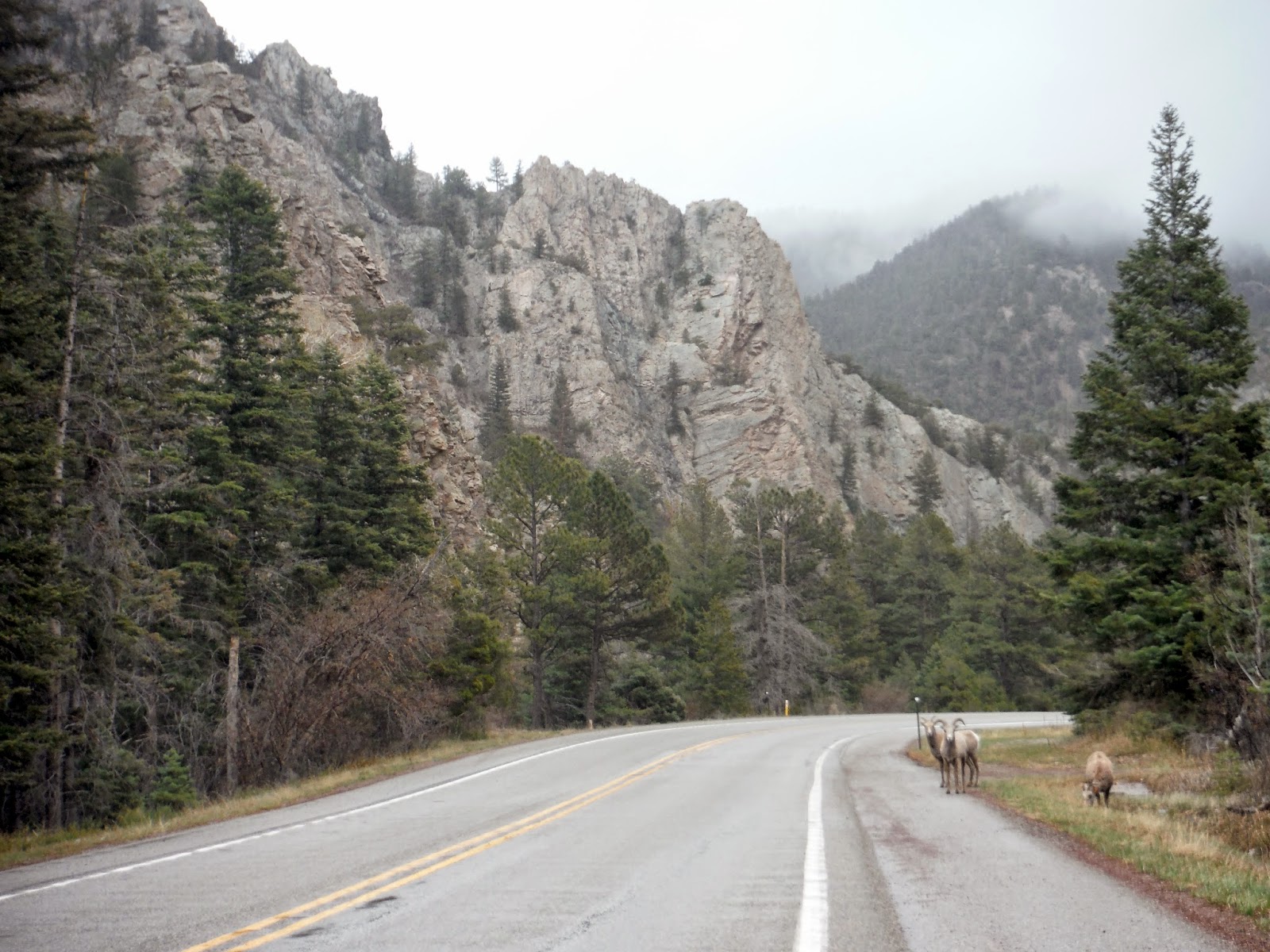
After it calmed down a bit, I continued down the road, and saw my first flock of bighorn sheep, calmly browsing along the edge of the road.


Bighorn sheep along Rt. 38
By here, I decided I should probably look for a place to aim for by evening, so I chose the highest state capital in the US: Santa Fe, at 7200 feet!  Relatively close, considering all the stops I had made just to enjoy the mountains.  While following some more mountain roads toward Santa Fe, I found a new road sign I haven't seen before:

Complete S-curve ahead.
While entering the general area of Santa Fe, I saw a fair amount of these awesomely decorated bridges.  I assume this is the outcome of the Native American culture that is so prevalent in NM.  Lots of cool art and stuff made from mud and stucco, etc.


Once in the city, I went to the ends of the Earth to find free parking.  For those in need, Otero St. has free parking for people on Sundays.  If it's 8am-6pm Mon-Sat, and you don't live on the street, you WILL be towed. Luckily this wasn't too far away from some nice streets downtown to walk along.  I decided I was going to check out places that serve you food instead of pulling out the camp stove and the coolers.  I found a neat place called Rooftop Pizzeria.  It was nice to settle down and not drive for awhile.

After dinner, I brought my car into the library parking lot for some catchup.  As you may recall, I wrote a few posts from that very parking lot.  I also debated for awhile where I would be camping for the night, and I chose a place that was only about 20 miles away.  What I didn't realize was that this place was deep into the mountains.  At 11,000 feet. Recall the forecast for snow?  Well if it was anywhere, it would certainly be there.  As I drove up the mountain, I got glimpses of the city lit up, which was truly a spectacular sight.  With as much incline as there was, and at this elevation, I was struggling to get the car to go any faster than 25mph.  Though that was acceptable since the radius of the turns around here was microscopic.

This place was supposed to be a ski area, but in the off season, you can camp there for free.  That would be assuming you can find the places to camp.  I arrived there in the dead of night, snow covering the mountainside, and half the parking lot.  I pull in, and wander around aimlessly again, like I did in Oklahoma.  It was in fact snowing here.  Perfect.  This is when I started to notice the effect of the elevation on my own breathing.  Normally walking across a parking lot is not challenging.  At 11k, I did notice myself out of breath.  That was a strange and exciting experience.

I found a place off the parking lot a bit, with a few inches of snow cover. I set up the tent and camping stuff, then turn my weather receiver on. "Sunday night, periods of heavy snow, accumulation around 5-10 inches, up to 15 locally."  This was not exactly what I had planned for.  I mean I could stay warm, but who knows if they plow the road up here in late April?  It would be a true test of Subaru AWD.  The only good news is that the winter storm warning was primarily for the eastern slopes of the mountains, and I was on the western slopes.  I went to grab the ice scraper from the car, so I would have it to use in the morning if need be.

I began to write in the journal, and of course the most comforting thing happened: a coyote frenzy that seemed way too close for anybody to want to be camping alone in a tent, 10 miles from civilization.  I'm not very easily scared, but this definitely increased the readout on my terror-ometer.  Luckily I did not get eaten that night.  Or if I did, I have been in a strangely realistic afterlife since then, and I'm also on a road trip across America.  And everyone I know is also in the afterlife?...

I set the alarm for 5am just in case there was 15" of snow.  Earlier would be better than later as far as escaping from the mountains successfully. We shall see in the next post what happened.  Also pictures.

EDIT: I always do this...I've forgotten to put the progress map in.  Miles to date: 3662.  Here y'all go:

260 miles of glorious mountain roads
EDIT: For those interested, this is what an oryx looks like: