Day 13
4.26.15
April 26th, day 13 of my trip, I woke to an interesting weather forecast. Snow. Snow in New Mexico, on the eastern slopes of the Sangre de Cristo Mountains. Timing was hard to figure out from an audio forecast, so I was living on the edge since the morning. In Mills Canyon, I had some high cirrostratus clouds, which is typically a sign of some incoming storm. The weather was still fair, so I planned my route during breakfast on the glorious picnic table.
I had no specific plan as far as an endpoint, but I certainly didn't want to go outside New Mexico, having experienced how long it took to get anywhere in the state yesterday. In preparation for this trip, I had starred a few places in NM to see, one of which being Wheeler Peak, the highest point in the state. Where I was currently, Wheeler Peak was only 150 miles away, though any chance of hiking it was shot with impending snow, as well as waking up too late to actually drive there, and have enough time to hike. However, I still wanted to see it, so I decided on Bobcat Pass, which is a road that drives around the north side of the mountain.
With everything packed up, I proceeded to get a closer look at the canyon walls before leaving the site. The ground was very soft, filled with cacti and pokey bushes. Nevertheless, I made my way to the walls.
 |
| The view toward the west wall of the canyon |
 |
| Holy walls. (The power of Jesus?) |
 |
| Ultra holy walls. |
 |
| East canyon wall |
 |
| My sway bar and where it ought to be... |
 |
| Urban New Mexico |
Finally, I made it to a civilization that provided me with some petrol, for my thirsty tank. I believe this was Springer, NM. I continued west to challenge the Rocky Mountains with a full tank. I was following scenic drives according to my atlas, with roads like Rt. 199, Rt. 21, and US-64. Somewhere along this stretch, I was driving along, looking in awe at the mountains that were rising up above me.
Then what I thought to be a gazelle tried to commit suicide via my car. I saw all of this peripherally, so take it with a grain of salt. I believe it was on the left side trying to cross the road, realized I was in the way, and decided to race me instead. Mission aborted and pseudo-gazelle returned to the left side of the road. I thought it was going to hit me, but we were both very lucky. After a New Mexican mammal search, I deduced that it was either an oryx or a pronghorn antelope. I believe it had straight horns, so I'm going with the oryx. (Sorry no pics, was trying to win the race.)
 |
| US-64 west heading toward Wheeler Peak |
 |
| Cimarron Canyon SP, north wall |
I turned north onto Rt. 38, and started the climb up to Bobcat Pass, the highest mountain pass in the state of New Mexico. This road was filled with tight twisties as well as some sweepers. This was when I really began to notice the lack of engine power. At sea level, the air is dense with oxygen, and you get the right air-fuel mixture, but up over 9000 feet, the air is less dense, and you end up with a gasping engine that needs to rev super high to have any power to climb the hills. Once I got the Bobcat Pass, I got out to take the picture, and did so very quickly because the temperature up here was very cold (probably 40s or so, compared to 70s down in Mills Canyon).
 |
| Bobcat Pass! 9820' above sea level |
 |
| Wheeler Peak, 13,159' |
 |
| Stunning concrete barriers, with some irritating mountainside carved out behind. |

Not long after, I heard some thunder, which was very exciting at this high elevation among the hills of giants. It began to rain, and then it began to do something that wasn't rain, and also wasn't quite snow. It was like small white balls of soft ice. It became very heavy, extremely blowy outside, and covered everything with a layer of white.
 |
| "Snow" in Red River, NM |
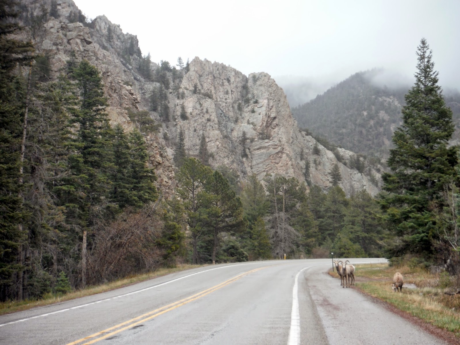 |
| Bighorn sheep along Rt. 38 |
 |
| Complete S-curve ahead. |

Once in the city, I went to the ends of the Earth to find free parking. For those in need, Otero St. has free parking for people on Sundays. If it's 8am-6pm Mon-Sat, and you don't live on the street, you WILL be towed. Luckily this wasn't too far away from some nice streets downtown to walk along. I decided I was going to check out places that serve you food instead of pulling out the camp stove and the coolers. I found a neat place called Rooftop Pizzeria. It was nice to settle down and not drive for awhile.
After dinner, I brought my car into the library parking lot for some catchup. As you may recall, I wrote a few posts from that very parking lot. I also debated for awhile where I would be camping for the night, and I chose a place that was only about 20 miles away. What I didn't realize was that this place was deep into the mountains. At 11,000 feet. Recall the forecast for snow? Well if it was anywhere, it would certainly be there. As I drove up the mountain, I got glimpses of the city lit up, which was truly a spectacular sight. With as much incline as there was, and at this elevation, I was struggling to get the car to go any faster than 25mph. Though that was acceptable since the radius of the turns around here was microscopic.
This place was supposed to be a ski area, but in the off season, you can camp there for free. That would be assuming you can find the places to camp. I arrived there in the dead of night, snow covering the mountainside, and half the parking lot. I pull in, and wander around aimlessly again, like I did in Oklahoma. It was in fact snowing here. Perfect. This is when I started to notice the effect of the elevation on my own breathing. Normally walking across a parking lot is not challenging. At 11k, I did notice myself out of breath. That was a strange and exciting experience.
I found a place off the parking lot a bit, with a few inches of snow cover. I set up the tent and camping stuff, then turn my weather receiver on. "Sunday night, periods of heavy snow, accumulation around 5-10 inches, up to 15 locally." This was not exactly what I had planned for. I mean I could stay warm, but who knows if they plow the road up here in late April? It would be a true test of Subaru AWD. The only good news is that the winter storm warning was primarily for the eastern slopes of the mountains, and I was on the western slopes. I went to grab the ice scraper from the car, so I would have it to use in the morning if need be.
I began to write in the journal, and of course the most comforting thing happened: a coyote frenzy that seemed way too close for anybody to want to be camping alone in a tent, 10 miles from civilization. I'm not very easily scared, but this definitely increased the readout on my terror-ometer. Luckily I did not get eaten that night. Or if I did, I have been in a strangely realistic afterlife since then, and I'm also on a road trip across America. And everyone I know is also in the afterlife?...
I set the alarm for 5am just in case there was 15" of snow. Earlier would be better than later as far as escaping from the mountains successfully. We shall see in the next post what happened. Also pictures.
EDIT: I always do this...I've forgotten to put the progress map in. Miles to date: 3662. Here y'all go:
 |
| 260 miles of glorious mountain roads |

I tried to post of an oryx here, but couldn't make it work. Oh well.
ReplyDeleteYour adventures are getting more and more interesting. Will I be able to continue reading with my momometer going?
PS - Glad to hear the coyotes have stayed at bay.
I added a picture of an oryx for you are anyone else interested.
Delete