Wednesday, December 30, 2015

A Final 2015 hike: Baldpate Mountain

This is an exciting hike to write about primarily because it is on this hike that I rolled over 400 miles on my 2015 hiking odometer.  Secondly, it is a new destination, which in itself presents some excitement.  It has come to my attention that there are infinite destinations even within the state of Maine, never mind the country or the world.  So forget list-hiking for me.  I know I won't ever come close to "doing them all", whatever that means to a given person.  For me, it's more about enjoying the experience, ideally having some nice views along the way or at the summit.  (In my case, imagining a good view because I get socked in with clouds.)

Though this hike took place on December 30, I consider it a New Year's celebration for the year of 2016, a tradition I have had going with my friend Eliot for three years now.  The temperatures have steadily climbed about 20°F each year, with our first attempt up Old Speck in January of 2014 in the neighborhood of -20°F.  Twenty above is quite balmy in comparison.

The Baldpate expedition commenced at 3:11am, after a good scraping of the windshield.  Off to pick up Eliot, then heading westward to the mountains.  Baldpate Mountain is accessible via Grafton Notch State Park, exactly opposite the trail for Old Speck.  Baldpate is known for open granite faces on the summit dome, and is potentially a good observation point because of this.  We arrived at the trailhead somewhere in the 7am zone, and took a meaty amount of time to get our gear all packed and our bodies warm enough to consider venturing into a winter wonderland.

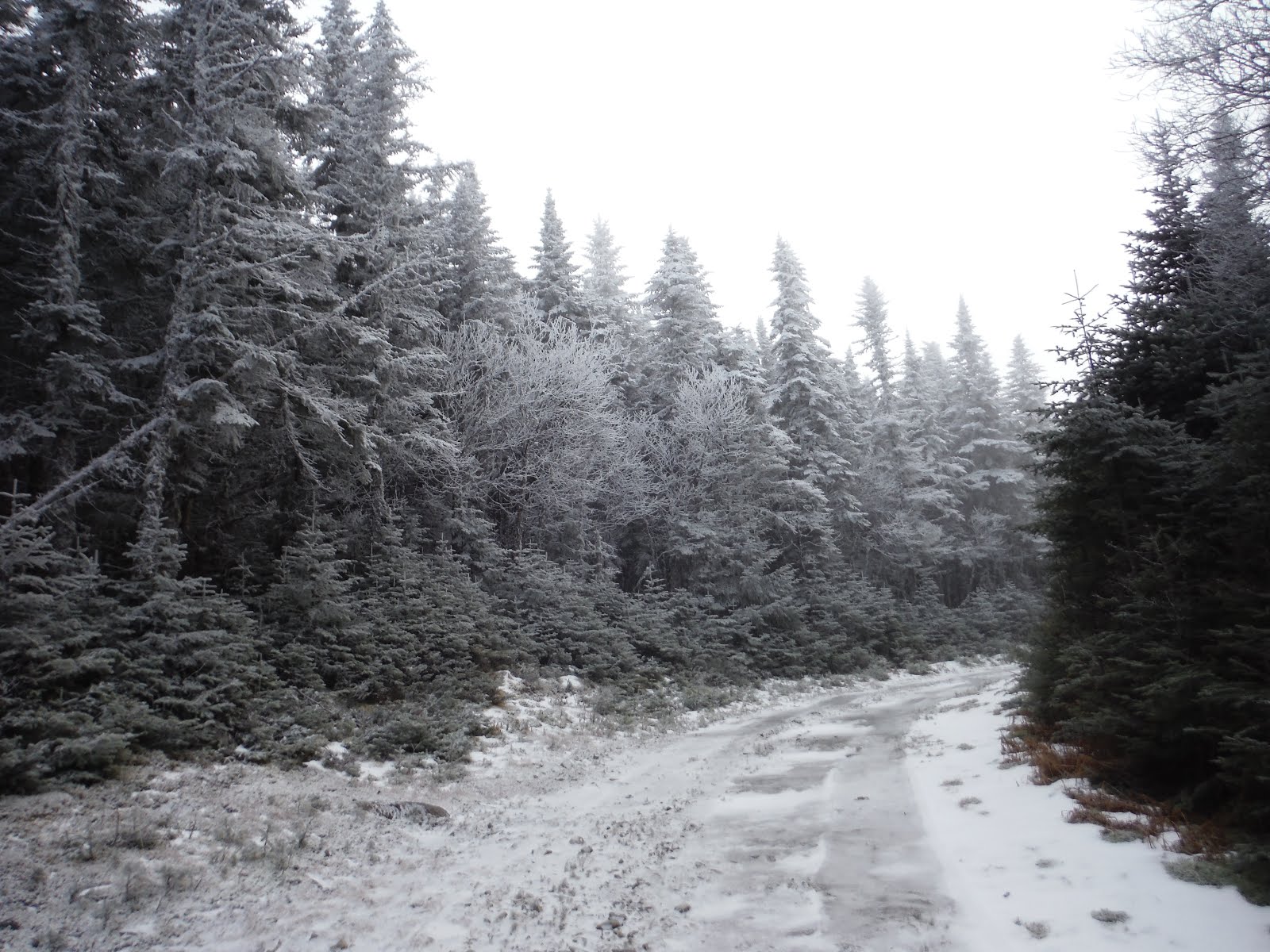
The Eyebrow of Old Speck
Both of us were unsure of the optimal footwear, with the option of mid-height shoes or boots.  I had brought my new mountaineering boots and crampons along in hopes of trying them out on a relatively tame trip.  I thought there was no harm in bringing the crampons, but it would be silly to do that without wearing the boots because the crampons install exclusively on my new boots.  So we went with the boots all around.

The trail to the summit is a section of the AT, so as per usual, the snow blown on the tree trunks made finding white blazes a good challenge. The trail was wide and easy to follow to start off, though we were first to venture out after the storm had blown through.  Not enough snow for snowshoes, so we left them in the car.  There is nothing quite like kicking into fresh powder in the mountains.  The coziness that exists because of the snow's insulating properties is unmatchable elsewhere. This is one of many reasons why I am now a four-season hiker.

There is a fair bit of up and down in the trail, as you meander between bumps on the western side of the mountain.  The AT does summit the west peak of the mountain, with views eastward toward the main summit.

The Table Rock Loop is a popular short loop that is partially congruent with the Baldpate Trail.  I have gone up to Table Rock in summertime, though it was via the much steeper Table Rock Trail, and then down the AT that we were ascending on this trip.  The trail out to the overlook is a 0.5 mile spur from the AT, and for purposes of summiting, we did not check it out...slight regrets, maybe.

In the final col between the unnamed bumps to the west and the West Peak of Baldpate, there is a lean-to, directly after which the trail ascends steeply with meager attempts at switchbacks.  It was here we first encountered ice flow along the trail, and broke out the axes for stability. Crampons seemed a bit much for here, since it was such a small section.

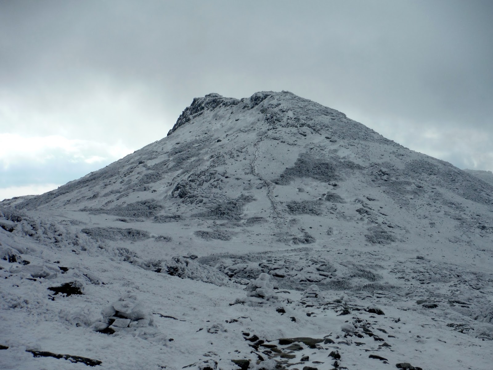
The lands flattens, and you can sense you are close to the top of West Peak.  The top is wooded, however a short walk past it will give phenomenal views into the upcoming saddle before East Peak.  In the wintertime, the bald granite slabs up the opposite side of the saddle are covered with ice and stand out well from the forested areas.  I was surprised at the calmness of the air around the west summit, albeit thankful since it allowed for easier munching of snacks.

Nearing West Peak

Eliot on West Peak
After seeing the first sign of ice flow on the downhill, I decided crampons were a good idea.  I struggled a little as it was my first time installing them in the field.  I had practiced inside before, and gotten the size calibrated, but in the field, everything kinda goes wrong.  Eventually, they were on, and boy, did we feel invincible with many spikes per footstep.  Any ice was completely in our control.

One of two ladders between the two peaks (just before applying crampons).
In the saddle between the peaks, there was some epic crunching of crampons on ice, perhaps one of the best sounds in mountaineering. Passing through intermittent krumholtz, we got to the base of the steeper climbs ahead to the east summit.  I was excited to try the front points on the crampons in combination with the rigid sole that allows for the front points to actually stay embedded in the ice as you climb.  The ease with which you can climb with the proper gear is staggering.  It is no harder than walking up stairs to be honest.  Even with glare ice underfoot.  I was impressed, and very excited to try another trip to get the hang of the walking style that is required by the rigid boots.

Equipped

Climbing!


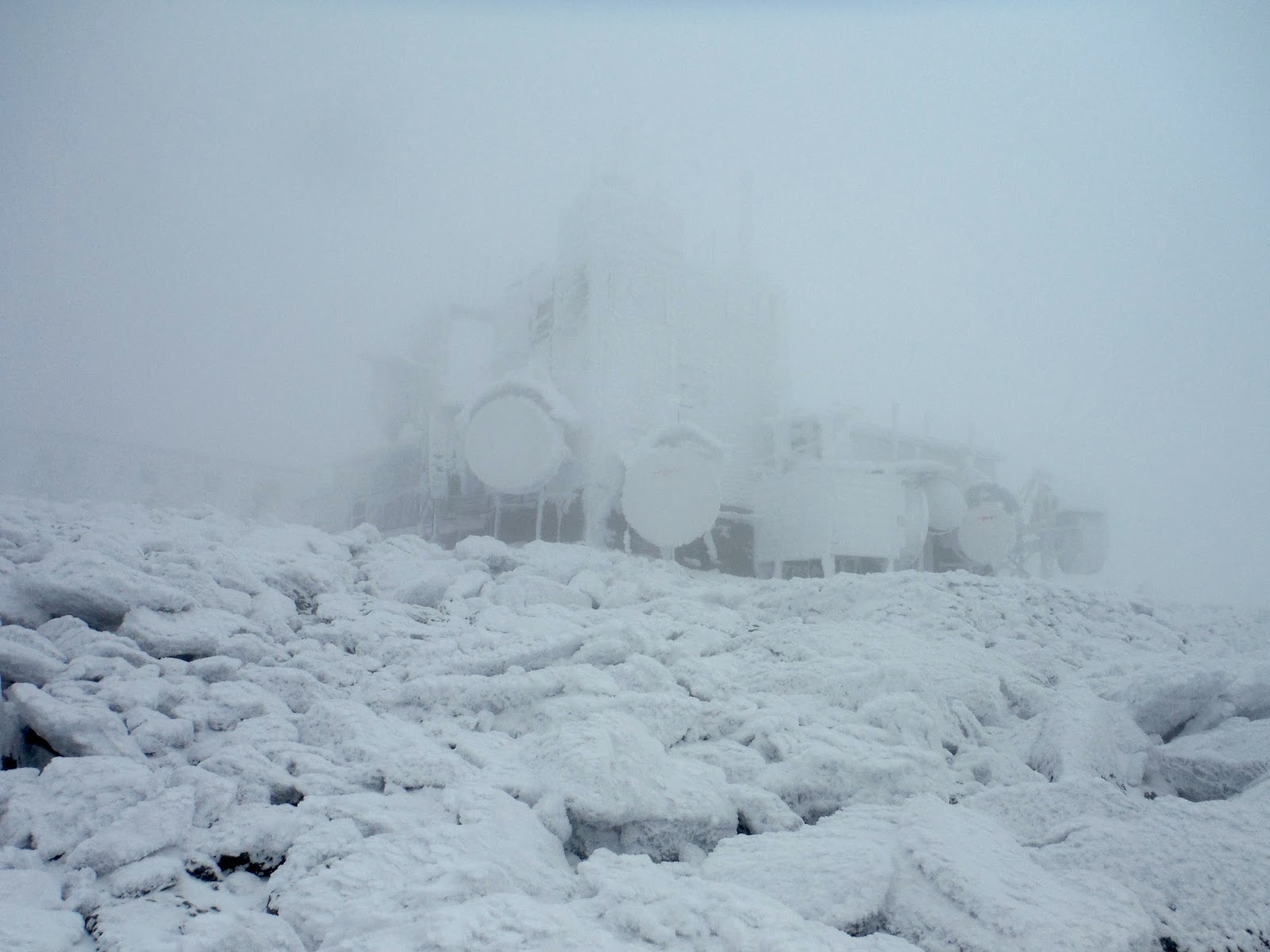
The rime up near the top was thick, and made it hard to look for the summit sign that we were searching for.  The short stubby trees looked much like a rime-covered signpost.  With help of a GPS to guide us in the cloudiness, we did make it completely to the summit, which is self-advertised as 3812'.  Interestingly, this mountain has more gain than Old Speck, at 4170' feet just across the notch.  This is because of the up-down-up characteristic of Baldpate.

It was up here that the wind did make an appearance on stage.  But like semi-smart climbers, we had acted in advance and applied extra layers. There is certainly something to be said for anticipating your environment.


The descent was nearly the same, though we kept crampons on until before we had applied them on the ascent - just until the ice flow that we first saw.  Descending on rocks buried on snow was tiring and dangerous for our ankles, so we bare-booted it from there to the bottom, sliding a good portion of the way.

Just before descending the bald patches of rock and ice
Alpine Sandwich, nothing like it.
Heading back to West Peak
A final look at East Peak
It was getting quite dark as we changed out of the crampons.  The temperature oddly had risen throughout the day, so some adjustment of layers was necessary...until we stopped for snacks, and then got instantly cold.  The joys of winter hiking.

We discovered fresh tracks on the Table Rock loop, so sadly we did not encounter them, but their essence continues on until it snows again. The parking lot was soon in view, and the removal of boots was already being anticipated.  I can only speak for myself, but I found I was not overly sore in the ankle/foot department considering I was in completely new footwear.  It seems I made a good choice on boots.

Here is the elevation profile and track from Google Earth.  Eliot's GPS claims it was 8.2 miles, so perhaps that is what it is?  The map says 7.6, but I trust a GPS a bit more since it was with us the whole time.


Hike Details
Miles hiked: 8.2
Time elapsed: 10.9 hours
Total ascent: 3300'

Wednesday, December 16, 2015

Highest drivable point in Maine + night hike of Bald Mtn. (Rangeley)

With my buddy Eliot in town before celebrating Christmas with his family out west, we took advantage of a beautiful clear sky on Dec. 16 to try and access the highest drivable point in the state of Maine.  This is not simple like it is in New Hampshire.  There, you could just drive up Mt. Washington.  In Maine, our highest point is Katahdin, which is not car accessible.  Neither are any of the 4000 footers, so that leaves out the 14 mountains above that threshold.  After scanning the Maine atlas for logging roads that seemed to at least get above 3000 feet, I think I may have stumbled across the highest "road" in the state.

This project was inspired by a youtube video made by The Fast Lane Car, linked here if you're interested.  They were high-pointing in various states, and they found a place in Maine that was 2400 feet or so, and I was convinced we could do better. With a Jeep at our disposal, we commenced the journey to western Maine, where many a mountain exist.

Somewhere near Embden, we missed a turn due to my not-so-prompt navigation skills.  Several attempts at taking a less improved road back to pavement led to gates not marked on the atlas (community service is what we're doing essentially), a logging area that was several feet deep in trees, and a confusing network of logging roads with more gates.  Nothing like getting out there right off the bat. Fun was had as we negotiated the different options and bumped along gravel and mud and ponds etc.

Our "tree graveyard" that we ended up driving up...
and going back because the trail ended
Deciding to focus on our goal at hand, we backtracked to the pavement and headed up to Stratton, where Rt. 16 would bring us to East Kennebago Mountain.  It is the west peak of this mountain that had an alleged road up it without any gates.  If successful, we would reach over 3600 feet, smashing the old record by over 1000 feet!

Mt. Abraham, ME
The beginning of this road to East Kennebago West Peak was fairly benign, just a gravel road with occasional puddles.  Two-wheel drive could negotiate this part with some good placement of the wheels.  Even after a few miles, the views just under the increasingly overcast skies were very nice into the valley below.

The road to success?
Five miles in, there is a distinct right turn into a grassy area, where we immediately encountered waterbars made presumably for drainage purposes.  These got old quickly as everything bounced around in the rear of the Jeep.  Diffs didn't need to be locked for any portion of this climb, though as we got higher, rime and ice started to appear around us.  We encountered a tree fallen in the path, which of course needed to be removed for passage.  Thanks to Eliot, we had a powerful winch on the Jeep and some pulleys to guide the tree off the trail for future off-roaders. Though I admit it took much too long for me to untie the knot that was looped around the tree.

The tree that was winched out of the trail
Soon the ice became very slick and the road steepened.  The ice on puddles did not break as we passed, and the temperature hovered around 29°F as we entered the 3000 foot range.  Already, we had surpassed the record of TFLCar.

At 6.25 miles, there is a bear right to a slightly steeper climb that is cut into the hill and circles upward to the summit.  The in-dash nav system was of no use at this point, aside from telling us elevation.  A handheld GPS with trails and roads was more useful, giving us a hint of road to follow.

Looks like the Black Forest of Germany
After 8.1 miles, we reached the top of the hill, with no broken parts on the Jeep, and plenty of good spirits.  The views would have likely been great to the southeast, as a sharp drop-off was visible, though shrouded in clouds currently.  There was a memorial on the summit of a snowmobiler who had died a few years ago, as well as a small building of unknown use with a short tower nearby.  Our elevation at the summit was measured by the Jeep to be 3664', and 3654' by the handheld.  The elevation gain from Rt. 16 was 2330', in just over 8.1 miles.

Summit of East Kennebago West, 3650'
After some lunch munching, we headed back down, where we encountered ice, and the ineffectiveness of the brakes was shown all too clearly here.  No animals were harmed during out descent, so all was good.  The descent was uneventful, though once we hit gravel, speeds of 25mph felt blisteringly fast after a period of crawling around at 7mph.

Elevation Profile of East Kennebago West
The next stop was to visit what's marked as a B-17 Memorial in the Maine atlas. This was out in Lower Cupsuptic Twp., just one town west of Rangeley.  The memorial is between Cupsuptic and Aziscohos Lakes on Deer Mtn. Road according to Google Earth.  Down these roads, there were many logging trucks, and a slight dusting of snow on the ground, which made things pretty in the dwindling light of evening.  I will break it to you: the memorial is a small display of a shirt, a few small plane bits, and a story handwritten on a piece of paper near the road.  We took a short walk through the woods in hopes of finding more plane bits, but there were none that we could see.  Mostly a disappointment, though I fully enjoyed exploring all the roads out in this area.  It shows that you could spend months out here and not drive all the roads.

Overview Map: Pink=offroading, Red=hiking
Next, I convinced Eliot into taking a short night hike up Bald Mountain in Rangeley on our way back home.  It is a short hike, just 2.5 miles, but with a tower on the summit!  This is exciting for both of us, so with some snacks in our packs, we set off under the setting crescent moon.  It was a beautiful night that I seem incapable of capturing with my camera.  Oh well...I hope you believe my story.

The climb got progressively steeper and icier.  I had brought along my micro-spikes in the event of such ice, though I thought I would need it much more on the way down.  In about 45 minutes, we reached the summit, which came upon us suddenly since our headlamps were the only light source.  It was a slightly rickety staircase up to the top, though the structure seemed intact.  Boy, it was cold and windy on top, but the reflection of the moon on the surrounding lakes made a tower climb very much worth it for both of us.

Summit of Bald Mtn., 2443'
I came down to ground level to have a sandwich.  (There is a website called alpinesandwiches.com which is, as you might guess, devoted to pictures of sandwiches in alpine environments.)  Due to cold hands, I did not whip out my camera for the instance.

Elevation Profile of Bald Mtn.
Hike Details
Miles hiked: 2.5
Time elapsed: 2.1hr
Total ascent: 910'

The drive home presented a challenge, as we were faced with a several hour road block as a car was being extracted from a gorge near Madrid, ME.  It was decided that pavement was not required.  Crosstown Road in Rangeley led us to Rt. 17, which was the nearest available route back east.  Out on this "road" we found ourselves once again in the back woods of Maine (a glorious place to be, of course).  Several miles in, we found a bunch of logging equipment, and most interestingly, an old 6x6 fuel truck that looked like it was from Russia many decades ago.  We could both fit in a wheel arch with no issue.  But then the skidders....with wheels as high as I am, and a claw that could, well, pick up a large tree, I was thoroughly impressed.  It was strange to come upon a scene like this at night, when it appeared out of no where as we rounded the bend.

We found the pavement of Rt. 17, and successfully made it to our homes that night, though it was into the morning hours by the time that happened.  The day was conquered, with most likely the highest drivable road in Maine driven, and a tower hike in Rangeley under our belts.


Thursday, November 26, 2015

Mt. Waldo & Mosquito Mtn. on Thanksgiving

On Thanksgiving Day, my cousin Julia and I went up to explore some nearby mountains.  (This may or nay not have had something to do with a long day the day before in the White Mountains...)

Mount Waldo, a prominent mountain in the horizon from my house was our first trip, and I apologize for not taking any photos on the hike.  The best I can offer is a picture of it from the other mountain we went to, Mosquito Mountain, which is just to the east.

Mt. Waldo from Mosquito Mtn.
We went up the service route for the radio towers on top from Tyler Lane.  It is the most direct route up nay mountain I've ever seen.  But it was quite icy, even with as warm as it was on Thanksgiving.  Micro-spikes were required for walking up some of the granite ledges near the top.  Here is the elevation profile from the last time I was up, since it's the same trail.


Hike Details
Miles hiked: 2.2
Time elapsed: 1.1 hours
Total ascent: 670'


Mosquito Mountain, the next hill to the east, is known for a granite quarry, just like Mt. Waldo is.  I'm not sure if there are trails up Mosquito, so we just headed up the road to the quarry.  There were many blocks everywhere, and the puddles were mostly frozen.


Julia standing on ice
And because heavy equipment is awesome, here is one of their excavators:


A granite bridge across to the other side, where the actual summit is.


There were two bigger mountains to the east that we saw from a viewpoint that overlooked the Penobscot River and beyond.  There remain unidentified, but perhaps a browsing of the atlas may reveal what they are and how to hike them.

Here is a map of Mosquito Mountain from Google Earth.


Hike Details
Miles hiked: 1.3
Time elapsed: 1 hour (including exploring of the quarry)
Total ascent: 310'

Wednesday, November 25, 2015

Thanksgiving Trip to Mt. Monroe and Mt. Washington

I celebrated Thanksgiving (well, the day before if we're being picky) by searching out some snowy mountains to hike with my cousin Kristen.  Luckily, we were able to find a free day in common to hike together.  (It can be tricky working weekends...)

The verdict was Mt. Monroe via the Ammonoosuc Trail.  Neither of us had been up that way before, so all was new and exciting.  I left my house at 4 in the morning to try and get a good start on the hike.  This is a wintertime 4am, where it's dark for a number of hours still.

I made it to western Maine before the dawn started to peek over the horizon behind me.  I stopped to take a picture.  The color spectrum in the morning really is one of my favorite things.

The morning glow in western Maine
I arrived only a few minutes late to the trailhead for the Ammonoosuc Trail.  I had come down Jefferson Notch road, which was thankfully still open, cutting off significant mileage from my commute.  It was here I got my first taste of snow from last night's storm.  Just an inch or so, but enough to make everything white.

Soon enough, Kristen arrived and we got our layers on.  I feel like this ought to be called onioning.  Getting all your winter layers on like an onion right?

Just a bit into the trail
As the trail follows the stream, we passed some views into the Ammonoosuc Ravine, where the high parts of the mountain were clouded over.  Soon, we found lots of ice where there are normally rock steps.  Time for micro-spikes.

Kristen on the ice
It just got icier and icier as we climbed.  Rime started to form on the trees.  Rime is one of the most beautiful things in the mountains.  And extremely fragile as well. Just a quick puff of air, and it can fall off.  But it stays on with the howling winds of the high hills somehow.

Icy ledges (trail goes to the right thankfully).
More ice negotiation, and we found ourselves approaching the col between Monroe and Washington.  The home of Lakes of the Clouds Hut.

Our first view of Mt. Monroe 
Lakes of the Clouds Hut, all locked up for the winter
It was 0.4 miles from here to the summit, and it was eerily calm on this ascent. Normally, I expect to be tortured with 60 mph winds up here, especially this time of year.  But no, it was mostly calm.

Kristen's photo of us from Mt. Monroe
Not much in for views today, but hey, I got my snow fix, so that counts for something.  We headed to the Hut again, where I hoped to be able to convince Kristen to join me to summit Mt. Washington as well.  I was unsuccessful.  We agreed to turn on phones as a safety, and we split ways, me heading up to the summit of New Hampshire, and she going back to the trailhead.

I was hoping for, but not expecting views from Mt. Washington.  It was rime-covered for most of the trail up, with some icy patches, but no issues with the micro-spikes. After a relatively slow 1.4 miles, I saw the weather station buildings materialize into view.  Quite spooky, and looking like the dead of winter, not a mere dusting from November.

Mt. Washington weather station
'Bout 8" of rime if y'ask me
Some friendly hikers from the area agreed to get my picture at the top.  It was uncomfortably windy at this point, so I spent a very short amount of time up here.

Yay!
As per usual, it started to clear as I descended.

Ice patches on the trail to Mt. Washington

I could see all the way to Mt. Monroe and down to Lakes of the Clouds Hut as I worked my way down.  Still pretty calm around here.

Mt. Monroe
The icy trail past the Hut was truly a scary experience on the way down.  I was wishing I had crampons and an axe the whole time until I was back on bare rock. But I made due with the micro-spikes.  I received a call from Kristen as I was around the ice waterfall that she had descended completely without issue.

I got low enough in elevation that the ice wasn't everywhere, and I got rid of the spikes (hoping to remember that I took them off).  You get used to having traction on ice, and then suddenly you are back to rubber - it can be easy to misstep on some ice and then you are done for.

I took the alternative trail out to the Cog Railway station, and I'm so glad I did. Skies had cleared, and the White Mountains were indeed white, contrasted by the blue sky and the green pines and firs from lower elevation.

Mt. Monroe over the railway station
Walking a bit further downhill, the rest of the mountains came into view, from Mt Jefferson all the way to Eisenhower or perhaps Pierce...I'm not 100% on that.


Driving out on the north side of the range, I got to see Mt. Adams in the evening light.  These mountains grab you by the eyes and make you look at them.  At least for me they do.  I just wanted to spend the rest of the day there.

Mt. Adams
Here is the day's trip as shown by Google Earth.  The map shows 9.2 miles, which I trust a little more than my hack-job tracing on Earth.


Hike Details
Miles hiked: 9.2
Time elapsed: 6.6 hours
Total ascent: 4220'