Day 12
4.25.15
To make up for my damp morning the day before, I awoke to perfectly clear skies at Black Kettle Campground. This was my view toward Dead Indian Lake:
I took a brief walk along the shoreline to fully experience the redness of the soil that is everywhere around here. It is so strange when I am used to good old Maine soil that is brown and black and filled with clay. This stuff is bright red, and very crumbly.
 |
| Shoreline rocks of Dead Indian Lake |
 |
| Beavertail Cactus. The dangers of the west are starting to make themselves known. |
On my way from the campground back to I-40, which I arbitrarily chose as my route west, I was hopping along the road when I saw a huge collection of wind turbines off in the distance to the west. I thought, well heck, I'm on a solo road trip, why not check them out. So I ended up in a network perfectly straight roads that make up "blocks" that are 1 square mile. All over I was seeing cows in these mile square pastures, and the wind turbines were getting closer. With the predictable pattern of roads, I just drove in a direction that got me closer, and turned where necessary.
 |
| An example of the roads that make up the western Okla countryside |
| A cluster of turbines. |
Now, I thought that Oklahoma was going to be flat, but what I really should have prepared for was Texas. In Texas, the highways are set at 75mph, but so are the single lane state roads. Everything is so expansive (at least in the TX panhandle where I was) that these high speeds make sense. Initially I was dreading this part of the trip, since I love the twisty roads. But there is something so vast about the emptiness and the hemispherical view you get that makes you feel so unrestricted. If this picture doesn't capture it, I'm not sure what will.
 |
| Rt. 70 southbound near Clarendon, TX. |
I had to pull over at this turnoff just to take it all in. Canyons are something that rarely exist in the northeast. Maybe we have a gorge or two, but something of this scale is unheard of in my home state.
 |
| Wombat lookin' happy as ever by the canyons |
 |
| I was having fun too! |
 |
| Grain harvesters offload into these, and then when this is full, it will offload into a semi-trailer which then goes off to the farm. |
Onward and westward, I entered the state of New Mexico, the land of enchantment. After driving around in this state, I learned that that slogan is as accurate as you can get. This was also my entry into Mount Daylight Time!
Soon after entering the state, I had to switch to state roads on my way to the next campsite in the Kiowa National Grassland. I was headed to Mills Canyon, which I had read has a campground at the top, and if you have a capable enough vehicle, you can drive two miles into the canyon and camp there. I bet you can guess which one I chose.
 |
| NM is also really flat. It seems even more flat because there are no trees. (The yellow stripe is from my solar charger sitting on the dash) |
All the roads here are lined by cattle fencing, and you see sometimes a large crowd of cows, other times maybe only two or three, but there are cows everywhere. They literally own all the land. Even with a GPS, I've learned that planning out gas stops is very important in this part of the country. "Nearest gas, 50 miles" is not uncommon. And town is defined as such here in NM: two roads that cross, maybe a barn, and a truck if you're lucky. It's funny to see these places listed on my atlas, and then you drive through, wondering where the "town" was. I suppose that everything is so spread out in this area that they wanted to put at least a few towns in for aesthetic appeal on the map.
 |
| Canyon rims start to appear. |
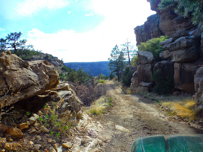
I found the 9-mile gravel road to the upper campground. There, I found a few people chilling by their RVs, and actually a horse trailer. I encountered the horses on my way down to the lower campground, on their way back up after a ride down to the bottom of the canyon. The road wasn't too horrible, though I went slow to avoid tire punctures with sharp rocks. It was very pretty look down into the canyon along the way, and seeing the Canadian River winding through.
 |
| Off-roading Wombat once again! |
 |
| Home for tonight! A fire pit too! |
The elevation of the bottom of the canyon is near that of Mt. Katahdin in Maine, around 5300', and the walls rose to about 5800'. It is so strange to imagine that a perfectly level line from this camp to Mt. Katahdin would match an elevation that rises 4000 feet from the surroundings of northern Maine. This is all part of the slow and steady climb to the Rocky Mountains. The midwest is flat, but it is ever increasing in elevation as you go west. Check out this cool image I found that illustrates this very well. It has the state boundaries so you can estimate roughly where I am. Mills Canyon is about at the top of the red range in northeast NM. You can see how through Oklahoma and Texas, there is a steady climb.
With a picnic table at my disposal, I decided to a) eat lots of food in a non-rushed environment, and b) break out my stash of Twizzlers. They were delicious. The sky was clearing from the slightly overcast it was before, and as darkness fell, the stars covered the sky. Also, the waxing crescent moon came up above the canyon walls before long. I made my best attempt at a campfire in the pit I was provided, but I had a fairly crucial problem, which is wood. There were cedar trees around, but you're not supposed to cut those up...only dead wood, and all I could find that was dead was these bushes that almost looked like tumbleweed. They were very dry, because I guess it hardly rains here, and they were small, so everything burned very quickly. Because of this, the fire did not last terribly long, but it was fun to have it for awhile.
Having been camping for a few days already, I was beginning to have some loneliness symptoms, so I figured what better way to cure this than to pull out the accordion and play all the familiar tunes! This was an experience in itself. Playing under the night sky in a canyon with a rising moon is something I haven't ever done before, and it was very therapeutic. In addition, it was nice to write down all the happenings of the day in the journal I've brought along. I've done some digital journaling, but when Im camping, sitting down to write it all out by hand is much better.
This day was a bit shorter as far as mileage, but this was the idea, since I was entering the land of more interesting terrain. I wanted to take more time to enjoy it without rushing. Day 12 miles: 463. Total miles to date: 3402.
Prepare yourselves for an interesting day coming up. Make sure your tray tables and seat backs are in the upright position. Seat belts would be useful too, since we're going up through the mountains tomorrow. Yeehaw!


No comments:
Post a Comment