Valles Caldera National Preserve
Day 11
6.1.25
On the morning of day 11, it was time to make our way out of Albuquerque after two luxurious nights in a a real bed, not to say our camping set-up was at all uncomfortable, in fact just the opposite. I'll take a quick opportunity to share my opinion on the camping gear we've had a chance to use for a bit now. The ExPed air mattress is extremely comfortable and if packed space is of no concern, I highly recommend this product - the materials are durable and not slippery, with a slight cloth feel to the top surface. In the warmer temperatures so far, it was most comfortable just to lay a sheet on top and sleep under a blanket. The mattress packs down very quickly, and with a separate outlet air valve, any air you squeeze out when rolling it up can't sneak back in, making the process much easier. It is still somewhat bulky when deflated but again it's not marketed as a backpacking item, more for car-camping or overlanding.
Regarding sizing: I was debating betweeen the MegaMat Duo M versus LW+, which is the wider of those two, but ended up going with the M since that size fits comfortably inside the back of the car, and I figure it would make it more versatile should either of us want to take any shorter car camping trips and prefer to sleep inside the car. I expect it will fit inside most small to midsize SUVs like the Forester, Rav4, CR-V, etc.
The tent I had found on facebook marketplace was the Meramac 2 by Alps Mountaineering, a very simple tent to erect—just two poles plus a short one for the fly. Our mattress size had a decent margin in both directions with room for some belongings at the head and foot as well as on one side, but the sides felt a little cramped since they slope inward slightly. It's recommended to have a tent footprint, however I find usually they are overpriced and a tarp will do the trick in 95% of cases. Conveniently, the tent dimensions were just larger than a 5x7 tarp, which is what you want to avoid water pooling, so we found a medium duty tarp online (5x7 was impossible to find in a store) and used this with great success. I have two main complaints with this model, namely, despite having zippable screen windows on the door flaps, the screened portion of the tent wall along the short edge is at the bottom rather than the top, so there's not much protection or privacy if you want to use the tent without the fly. The other complaint is that there is only a small overhang if you want to keep shoes outside the tent and keep then dry, and perhaps a vestibule design would be better, but I'm not complaining much as I got the tent for $50, less than half its original value.
We brought our usual home pillows with us since we had the space for it, and for car camping I have no problem with that luxury, since my sleep quality has such a big affect on my mood the next day, and I struggle enough to get good rest. Yilin on the other hand is blessed with the ability to get good rest almost all the time, and fall asleep quickly! I'm only a little jealous.
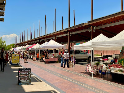
Anyway, back to our departure from Albuquerque! First stop of the day was to the nearby Petroglyph National Monument, which is directly adjacent to the city to the west, in fact the Peidras Marcadas Canyon trailhead we were aiming for is right in a suburban neighborhood...a bit of an odd feeling. We had arrived by late morning, and were checking out the route we wanted to talk when a park volunteer wandered up to us, curious first about the Maine license plates on the car, an uncommon state to see in New Mexico no doubt. After chatting briefly, he was shocked to learn we had driven all the way out from the east coast, and was apparently a big fan of our travel style since he saw my paper atlas sitting on the dashboard, not just relying on our phones. We learned his name, Tom Hughes, and not only is he a local resident of that neighborhood, but along with his wife, he runs a potato museum that they started decades ago in Brussels, with exhibitions in Ottawa and Washington DC over the years. They have a youtube channel here as well, though I've yet to thoroughly check it out.
Tom was sporting a very interesting nose shield attached to his sunglasses along with a huge hat for sun protection, and I think he has the right idea, since it was extremely toasty even before noon. He gave us the best route for us to take from this trailhead as he regularly maintains these paths - basically take the loop and stay to the right whenever there's a fork, and then come back straight along the other side, and we'd get a chance to see all the petroglyph sites along the way. He asked where we were headed next, and I mentioned passing Jemez Springs, then Valles Caldera, Taos, and eventually going to toward Mesa Verde National Park, and we got his full approval, saying that was a great route.
Armored against the hot sun with our thin hoodies, wide-brimmed hats, and some water, we set off along the sandy path. The air was very still, discouraging us from moving terribly fast, but this was a short trail thankfully, only just over a mile roundtrip. The canyon is more of a minor escarpment, with a plateau to our righthand side, large blocks of black volcanic rock tumbling down the slope. These are the rocks where the petroglyphs can be found, shown clearly by little viewing areas.
 |
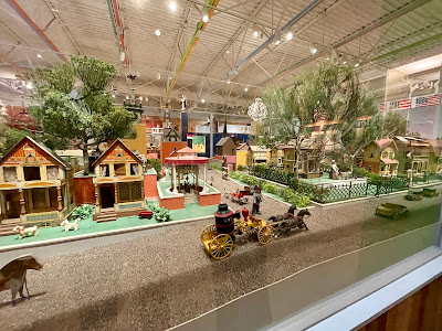
| The new Goodwill find! |
 |
| Lizards |
 |
| This shows how close to the city the petroglyphs are |

 |
| US-550 |
 |
| A small picnic area along NM-4 approaching Jemez Springs |

After turning onto the smaller 2-lane highway, we were winding our way next to a small stream, with campsites here and there, surrounded by vivid rocks around each corner. As we entered the small village of Jemez Springs, we saw a historic Pueblo building on the roadside, called Gisewatowa Pueblo. Had we not expected such a full day, we would have taken a tour from the museum, but it was cool enough to see from the parking lot too.
 |
| Gisewatowa Pueblo, Jemez Springs NM |
 |
| Jemez Soda Dam |

We drove about a mile down a maintained gravel road to the welcome center, where I learned that entry into the heart of the caldera requires a free backcountry permit. I was discouraged at first, not expecting this, however on the Recreaction.gov app, I was pleased to discover a few permits were available for that day, and as long as we exited the main gates by 6pm, we'd be good to go. That gave about 4 hours to explore! Another mile past the welcome center is a ranger station beyond which you need daily codes from the rangers to pass. The Recreation.gov app turned out to be a great resource for us, since the annual parks pass only covers entry into the parks, but if you need to reserve campsites, backcountry permits, or tours, all of these are accessible within the app and populate based on your location (or you can search manually).
While I didn't come to Valles Caldera with the main goal of wildlife viewing, this venture proved to be way more fun than expected, and it was yet another busy day for my Nikon camera, which Yilin and I both used heavily here. We were greeted by a huge number of prairie dogs throughout the entire drive, about 28 miles round-trip, and a large herd of elk very far into the meadow they looked like ants, first spotted by Yilin. We also saw an elk skeleton near the road and a mountain bluebird at our turnaround point.
One funny moment occurred as we entered the ranger station by the gates to receive the code, as Yilin was wearing a new pair of yoga pants this day that were a bit too long, hoping to fasten them up higher somehow. She asked the ranger for paper clips, which he was not expecting at all, and he remarked that in his time as a ranger, he's never been asked this question before He rummaged around in the back office for a minute and was able to find some, so he gets a high rating from us!
Throughout our entire drive in the caldera, I think we saw maybe 4-5 cars and a couple bikers along the road, and a few fishermen near some small streams, but other than that, our companions were mostly the prairie dogs. This allowed us to easily stop and go as we wished without holding anyone up.
 |
| Distant rain clouds |
 |
| Very distant elk herd, pc: Yilin |
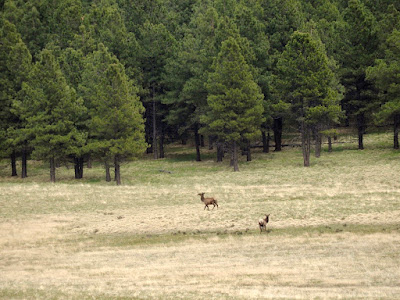 |
| Elk duet by the forest, pc: Yilin |
 |
| Elk skeleton |
 |
| Prairie dog keeping a lookout |
 |
| pc: Yilin |
 |
| pc: Yilin |
We stopped to enjoy our picnic lunch of tortellinis at one of only a few road junctions, this one at the far north end of the meadows, where I spotted a mountain bluebird perched on a tall plant stem above the grass. While taking a number of photos, I saw it flit occasionally between some different stems and boulders before flying off, but its bright plumage stood out so brightly against the muted color palette here.

On our way back out, we saw a few....shall I say round prairie dogs that I thought we should feature:
 |
| pc: Yilin |
 |
| pc: Yilin |
 |
| pc: Yilin |

Our leisurely trip out and back took us about 3 hours, and for once we finally were able to relax and enjoy the afternoon, not having to rush somewhere. I do wish we had found more of these moments, but I think taking our time here is one thing that makes Valles Caldera stand out from the trip.
We were planning to stay somewhere in the Taos area for the night, so after exiting Valles Caldera around 5pm, we headed northeast, descending down the other side of the mountains into a beautiful valley, and without realizing it we came up to what I learned after the fact was a military checkpoint for Los Alamos. I wasn't expecting this, so I approached the gatehouse hesitantly, not knowing exactly what this was, however I said we were looking to go toward Taos, and he just asked for my ID, and gave directions that matched my GPS, and told us not to take any pictures on the right side of the road until we were out of town. After passing the military facility, the road wound us down one of the most beautiful canyons I've driven through, enhanced by the evening light no less.
After passing Española, we were driving on NM-68 when we crested a hill to find a dramatic gorge cut into the otherwise flat landscape, thanks to the Rio Grande, and I had to stop and capture the view.
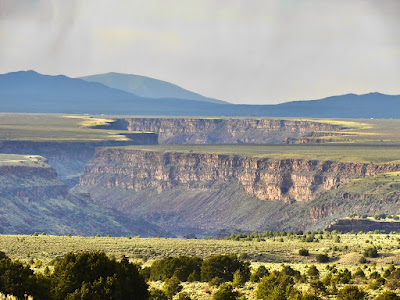 |
| Rio Grande Gorge |

I had found a potentially excellent camping spot a little north of town that had several dispersed campsites right on the canyon rim overlooking the Rio Grande. The sky was super ominous this evening, threatening rain and thunder from all angles, yet the sunset was still visible as we drove on.

Yilin captured this video crossing the Rio Grande, and what I think was someone's wedding halfway across the bridge? Further along US-64, we passed the most interesting eco-houses I've ever seen. Looking at the map as I write this, I discovered these houses (or mansions...they all seem pretty huge) are made by an company called Earthship Biotecture. They are designed to be 100% off-grid with solar and/or wind power, self-sufficient, made from recycled and upcycled materials, and most feature a greenhouse. I guess you can take tours of some houses, book stays at some of these Earthships for a heftier price, or for a fortune, you can also buy one. It was a bit dark as we were passing through, but you can check out their website for some cool pictures and information if you're curious.
Shortly after this, we got to the end of the pavement part of our trip, turning right onto a bumpy gravel road crossing the sagebrush desert with some turn-offs for car campers not unlike ourselves, but I was optimistic that we would find a spot right on the canyon rim further along, and while the prime spot was (as often is) occupied, we found one open, and the view did not disappoint at all!
 |
| The Rio Grande canyon view |
This would be our last night in New Mexico, as Colorado was waiting for us the next day, with plenty of its own wild country for us to explore. From our day at Carlsbad Caverns, it feels like we fit in about two week's worth of adventure into 4 days, and it remains one of my favorite states, as there's such variety on offer. Our next destination would be Mesa Verde National Park, in southwest Colorado, but I'll finish this post with the day's route map.
 |
| Day 11 Route map: 230 miles Total mileage: 3530 miles |