Carlsbad Caverns, New Mexico
5.29.25
I woke first on this morning to natural light filtering into our tent window, and my thoughts quickly went to the fact that today, I would finally get a chance to visit Carlsbad Caverns! Also, we would be crossing into Mountain Time at the TX-NM border, so technically we'd get a 25-hour day.

The sky was a perfect blue, and the weather was nice, and I went to the car to get breakfast going, however it wasn't long before I was certain we'd get dumped on with rain within minutes, so we hurried to pack up the tent and what I could of the kitchen. However the darkening sky was merely dark and slightly windy, and no rain came. Nature's fake-out I guess.
Our plan for the day was to get to Carlsbad Caverns for mid-afternoon, walk the tour from the natural entrance, and then attend the bat flight program, which is a short ranger talk right by the cave entrance in a stone amphitheater, after which visitors get a chance to view hundreds to thousands of bats as they exit the cave in search of their nightly bug meals. I had read that this is a remarkable experience and worth visiting the park in the evening to witness, on top of the self-guided cavern tour itself. There is lots of public land around the park in southern NM, so we planned to camp the next night somewhere in the Carlsbad area.
Our trip from Big Spring TX westward brought us through a landscape completely barren of any life except for extensive oil industry. While sections of our route along state highways were beautiful, we were shocked at how flat and empty much of the area was, meanwhile the road was well trafficked with large trucks and what I can assume are workers for the oil businesses around here. We felt a bit out of place as road-trippers here.
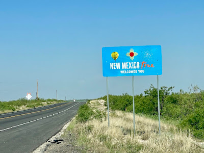
Before long, we crossed into New Mexico and into Mountain Time Zone, where we would stay for the majority of our trip. Compared to some others, this welcome sign to the state was not as impressive, but the license plates are definitely some of the nicest designed in the country that I've seen. There are two main styles that have either yellow background with red numbers, or a turquoise background with yellow letters, and we did see a red chili style as well, with a black background, with the slogan "Chili Capital of the World." My other favorite thing about the New Mexico plates are the fact that they specify "New Mexico, USA," perhaps to make it clear to any confused Americans that New Mexico is indeed part of the US, and not part of Mexico? If so, I am disappointed in our education system.
We stopped briefly in Jal, NM and drove a couple miles up the road to see a Cowboy Statue that was marked both on my map and on a green roadside sign. I was curious what we might see, but didn't expect this:
 |
| Cowboy Statues, Jal NM |
 |
| A large cloud of Carlsbad Caverns |
 |
| Finally at Carlsbad Caverns! |
 |
| One of many brightly-colored hot rods we saw in the parking lot here, I'm assuming this might be some type of group or car club that travels around different areas, since the license plates were from all over |
We got our cave entrance receipt inside the visitor center, and headed the exhibit hall, which features a 3D model of the cave, which gives a slightly better sense of the geometry of the cave, however even still, I think caves are notoriously hard to visualize, since they are voids that twist and turn in 3 dimensions, and once I was eventually on the main path underground, I lost most of my sense of direction. There was a 2D map that showed both the surface features and also where the cave is below that was more helpful to me.
From the exhibit hall, it's a short walk down a path to the cave's natural entrance, where we saw the stone amphitheater where we'd be back in the evening to see the bat flight spectacle. (There is the option to take an elevator to the bottom, near to the big room area, and though we'd be taking this back up afterward, I think it's fun to see the natural entrance, which adds about one more hour to the underground trip.)
 |
| Carlsbad Caverns Amphitheater |

The entrance area is inhabited by cave swallows, which we thought were bats at first, but then we realized bats don't make bird sounds, nor do they fly around during the day. The temperature difference as we descended was considerable, as was the increase in weird smells, no doubt from the bird and bat droppings, and the mixture of inside and outside air.
 |
| Looking up out of the natural entrance |

A bit further down, we got to an area with a flat roof, descending even further down with switchbacks galore.
 |
| Just a bit of natural light finding its way in at this point |
 |
| A big area of flowstone |
 |
| A tall, but not the largest stalagmite, Yilin for scale |
 |
| This map was the most helpful to me, and we chose to do the full loop on the right side |

Above is a picture from the big room, where at most times you can see to the opposite wall. We thought this hole on the left looked like an eye!
 |
| See the pathway above where we came from |
 |
| Dolls Theater: soda straws and small columns |
 |
| A small mineral pool with a bit of rainbow colors, likely from bacteria |

Exiting the visitor center and breathing clean air again was so refreshing, after we had grown accustomed to the somewhat stale cave air. The sky was threatening to rain as we got outside, but at least we weren't baking in the sun. Looking east out onto the forever flat land below was so cool, as was seeing the rest of the mountain range out to the right where Guadalupe National Park lay obscured by haze.

 |
| As we were looking around, we turned east to discover a rainbow! |

We decided to drive up into downtown Carlsbad to get dinner at a Mexican restaurant called El Jimador. It's a bit further than it looks on the map, due to the winding park road, so it's about 40 minutes. We did get some rain on the drive up, but we welcomed that do cool us down a bit.
Yilin wanted to try something unusual on the menu, and went for their Molcajete Jimador - a meal that was served in a sizzling hot molcajete (Mexican version of mortar and pestle), featuring shrimp, chicken, steak, chorizo, onions, salsa, and cactus leaf. It turns out the cactus leaf is extremely sour, at least in the way it was prepared here, but otherwise, her review of the meal was quite good! I ordered Pollo Palapa, a comparatively more tame meal featuring chicken in queso with rice and beans, which I fully enjoyed.
 |
| Molcajete Jimador |
Now for the bat flight, I won't be able to show you any photos or footage of the event since any electronics are prohibited since the bats are very sensitive to light and noise. We were required to actually shut our phones off. I will try to describe the experience as best I can. We had a ranger answering some questions from our medium sized audience that night, and he instructed us to wave at him if we started to see any bats emerge from the cave, since he was facing our way. It was a few visitors next to us that spotted the first bats, and from this point he had told us to try and be as still and quiet as we could and just observe. Of course we're allowed to leave at any point, but just to exit quietly. Bats, unlike the cave swallows we saw earlier, must flap at all times to stay airborne, and because of this, the flight pattern is noticeably different, and more fluttery, since they can't glide. The primary bats here are Mexican free-tailed bats, which are much tinier than I expected, only 3-4 inches long, with a wingspan of about a foot. They came out in swarms, circling in front of the entrance to gain altitude before turning off over the mountaintop to look for bugs, primarily moths, to feast on. The ranger told us that they usually fly over toward the Black and Pecos River valleys, their flight distance averaging about 10-25 miles each night. It was quiet enough for us to hear the wings flapping before they disappeared into the sky—certainly one of the more unique experiences we have had.
I don't recall what time the bats started coming out, but we stayed for maybe 30 minutes watching them, before quietly sneaking out to our car. The sky had mostly cleared and we had a view of the crescent moon setting over the mountain.

I had found a nearby car-camping spot not far down the road called Sunset Reef Campground, which has about 10-12 spots for RVs or tent/car-campers, and there were only a few people set up by the time we arrived at 9 or so. The sites had picnic tables with a metal roof over the top which was quite nice, I would come back here if camping in the area.
 |
| Starry view from Sunset Reef CG |
I had been poking around the map earlier and discovered Guadalupe NP just to the south was home to Texas's highest peak, Guadalupe Peak, and while I know Yilin wouldn't have much interest in doing this hike, I thought it seemed possible for me to give it at go since we were in the area, and she was fine with hanging out at the trailhead in the morning while I hike. The elevation of the summit is 8750', certainly higher than I'm used to on the east coast, but it was time to get back into some bigger hikes with a few thousand feet of elevation gain so my legs don't go soft sitting in a car for days on end. I was planning to get up predawn so as not to waste the whole next day. I'll save this adventure for the next post, and for now, leave you with our route map from Day 8.
 |
| Day 8 Route map: 274 Total mileage: 2592 |
No comments:
Post a Comment