Beartooth Pass, WY
Day 53
6.5.15
This day of my trip was jam packed with activities, weird earth-stuff, all kinds of weather, an enormous amount of elevation change, and a relatively small amount of distance traveled. Our first stop was to the infamous Yellowstone NP, which as I mentioned before, was about an hour's drive south from Livingston, MT. We had no plans for exactly what to do there, but we were in the mood for a substantial hike, and preferably something that would give us a little bit of everything.
Indeed this is what we got when talking to the guy at the backcountry office. He suggested the Seven Mile Hole Trail, which is one of two places in the park (which is huge, mind you) that you can hike down to the Yellowstone River itself. There were waterfalls, geysers, and other funny things along the trail that we could expect to see. The drive to the trailhead was still a ways off, but we stopped almost immediately at this strange scene of otherworldly things called Mammoth Hot Springs.
 |
| Tidal pools that aren't tidal? Dripstone? |
 |
| Cool-looking terraces of water. |
Along the way, we climbed to nearly 8000 feet, snow became regular on the mountain peaks, many of which were above 10k. What was also neat about the landscape here is that there are meadows that fill in the space between forested areas. For all I know it could be scraggly hedges up close, but it looks all nice and soft like grass from a distance.
After a session of Nathan not being able to read maps, I finally found to correct road that went to the trailhead. The tourists were numerous, but squeezing past them, I was able to get a sweet view of the Yellowstone River in the canyon it has been cutting for years and years. I learned that this river is the longest undammed river in the US at 692 miles long.
The trailhead began at a glacial erratic, and according to the maps, was supposed to go along the top of the canyon for a few miles before dropping down to the base where we could get up close to the river itself.
We were presented with a very tall waterfall, the name of which I can't remember, but it's the biggest one around for sure. I was amused to see a small patch of snow at the base of it, which is impressive for June, though I suppose high elevation can surprise anyone.
 |
| Waterfall! |
Not long after encountering he meadow, we heard some distant shouting and clapping in the woods. This went on for several minutes before we found the source of all the noise. It happened to be coming from two girls who were on their way back from the hike we were doing. They were scared of bears, and thought that shouting, clapping, and singing would scare them away. They apologized for being obnoxious (this is exactly what they said), and continued with the symphony of noises. Honestly, I feel bad for any hypothetical bears. I imagine their attitude would have been somewhere along the lines of "Shut up already, would you?"
Soon the trail began to descend into the canyon, and it got noticeably hotter with each step downward. We came across a dormant geyser, though it was still hissing steam and horrific odors from some holes near the top. The green and pink splotches along the side are bacterial extremophiles that somehow enjoy living in a world of hot acidic water dripping over them.
 |
| Dormant geyser |
I did accidentally step close to a vent in the ground and got a nice hot breeze on my legs. That was startling, but far from fatal.
As we got closer to the river, things greened up again, and you could've told me I was in an alpine meadow. A pretty trail indeed.
Finally the Yellowstone River itself was before us. It is a very quick-moving river, and quite cold as well. Good for refreshing if you are feeling too hot from being down in the canyon.
 |
| Yellowstone River |
On our way up, I spotted a different style of waterfall across the river.
The remainder of the hike was interesting because we kept hearing thunder as we passed the gurgling hot water pools again. I saw a piece of lightning strike the canyon a few miles behind us, as well as dark clouds. I figured it was only a matter of time before we got drenched. However, to our delight that never happened. Rain did start to trickle out of the sky, but nothing serious.
Total hiking distance was 10 miles, and elapsed time was 4.6 hours, including the lunch break. The descent into the canyon was about 1000 feet, but it was focused in the last mile or so of the trail, so not what you'd call gradual.
Returning to civilization, we drove by a neat rock formation that looked like basalt columns at the base, but who knows what on top.
 |
| Cool rocks! |
 |
| A+ for thinking about not wanting to ruin the photo. |
PART II: Beartooth Pass
I had been told about Beartooth Pass, and I had no idea where it was, or what state it was in for that matter. It was labeled on my atlas however, and it was just east of Yellowstone on US-212. The choice was clear, Beartooth or bust. At an elevation of 10,947 feet, it is one of the highest roads in the US. The excitement was building for me as we neared this area.
We came across a large field filled with hundreds of bison and numerous bison calves. Needless to say, this caused a serious traffic jam. The calves looked like cow calves, not oddly proportioned bison like they were to become.
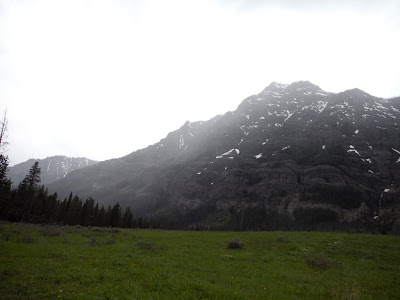
The mountains were gnarly as we exited the park to the east on US-212. Things were beginning to get foggy, as we were gaining elevation for a few mountain passes coming up.
After a few switchbacks, we got a glimpse of the outlying mountains in the area, and they were very pointy! I also noticed a sedimentary layer that stretched as far as I could see in both directions partway up the mountains, reminding me of the Coconino sandstone of the Grand Canyon.
Here is a closeup of the extra pointy mountain we saw:
And here's Emma in front of all the cool mountains.
 |
| Emma and mountains |
I made a 30 point turn to get out of there since the road was narrow and I had the turning radius of an aircraft carrier. (#wagonlife)
Back on the pavement, the road was cut so tightly into the hillside, exhibiting lots of cool-looking rocks around every corner. Here's one cool spot we saw.
Glacial lakes and ponds started to appear and become a frequent sight. This one still had ICE in it! Icebergs in Wyoming in June.
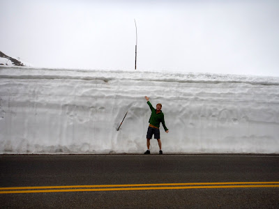
Many switchbacks later (thanks WyDOT for making the grade not too steep out here, my car wouldn't have made it up the hills at this elevation), we approached the wildest snow I've ever seen by a road, perhaps anywhere. This appears to be about 12 feet of snow, since I am 6 feet on the dot. Just imagine the process of removing this much snow. I saw an industrial snowblower a few corners back that I assume was part of the process. Impressive to say the least. Now I know why they have really tall sticks lining the roads around here. It's so you can find it when nature drops like 10 feet of snow in mid winter.
The three of us (me, Emma, and Wombat) successfully made it to Beartooth Pass, standing at 10,947 feet above sea level - that's over 2 miles vertically! For the record, it was snowing. Not really accumulating, but nonetheless snowing. And cold, did I mention cold?
 |
| Beartooth success! |
 |
| Taking it all in |
This mountain pass brought us back into Montana, where 6 miles of switchbacks brought us down into the town of Red Lodge. Not a whole lot was going on there, but we found wifi and came across a place to camp that we had just passed a few miles back on the outskirts of town.
The day was rich with views and hikes and crazy terrain, which make up for the low number of miles we covered. We drove 239 miles, though as the crow flies it was only 70 miles. Mountains are hard to get around. The total is now up to 11,123.
 |
| Day 53: 239 miles. |


Thank you for writing your interesting blog. I currently am down for the count with a fierce case of G-I distress.
ReplyDeleteThis was an excellent use of my unplanned stomach torture.
I have a Beartooth mountains souvenir hiking hat from our trip to Wyoming/Montana which your blog brought back happy memories
(Above) This is Charles from the frontier county of Piscataquis in central Maine. 3.7 people/square mile. Mainepiazza@gmail.com
ReplyDelete