With gear purchased and testing in progress, the next step was to learn as much as possible about the mountains we were planning to climb. There is nothing I hate more than going into a trip unprepared. It's one thing if you're on a short summer hike on the east coast, but a winter expedition to volcanoes in the Cascades is a big deal. Initially, our plan was to try to hit two state high points: Mt. Hood (11,250) and Mt. Rainier (14,409).
It was in this planning phase that I discovered that my ascent up Borah Peak in Idaho (12,667) from May 2015 was in fact a bust. Socked in with clouds, I had made it to a false peak just above Chicken-out Ridge, nearly a mile and 1000 vertical feet from the actual summit. This began clawing away at my insides, and I needed to get back to that mountain and give it another shot. I asked Noah his thoughts on it, and he said "sure, put it on the list!" I may have left out the fact that it was 700 miles away from Mt. Hood.
 |
| Borah |
So Hood, Rainier, and Borah. I was almost more focused on Borah at this point, but Noah was focused on Hood, so I figured we would eventually get all the information we needed with frequent "war meetings" as he puts it. After looking into Rainier for a few nights, I had a gut feeling that was bad about it, so I told Noah that I thought it was outside of our range to pull it off, and I just didn't feel right about it. I felt good about Hood and Borah, so we continued our research on them.
Borah has a simple way up, and that is to follow the trail from Birch Springs Road in Custer Co., then follow Chicken-out ridge to the summit. My memory of the route from 2015 is still quite vivid, and looking at past pictures and route maps, I felt comfortable leading a climb up there, so long as we both had appropriate gear.
Hood was more complicated since it was a new target for both of us. South side routes were by far the most common, but near the top of Hood is where several routes diverge, and have a vast range of technical difficulties. The two common routes are the Pearly Gates and the Old Chute. The Old Chute cuts off to the left and avoids a big hazard called the bergschrund, just above the Hogsback, which we thought to be a good idea since neither of us is trained with rope skills and crevasse rescue. Best to just avoid that altogether and climb to the left of it. In either case, we knew we were in for a climb that approaches 45° slope (100% grade) while going through the chutes.
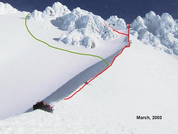 |
| Old Chute (green) and Pearly Gates (red) from the Hogsback. Courtesy cascadeclimbers.com |
I sought advice online for some other climbs that we could do in the area in case of bad weather during the week I was planning to spend out there. Someone suggested Mt. Saint Helens via Worm Flows, so I looked into it. At 8,366', it was considerably lower than the other objectives, but still with an ascent over 5000 feet involved. That would be a good starter for me, considering I would need to get acclimated to higher elevation for a climb of Mt. Hood.
 |
| Mt. Saint Helens, courtesy Noah Pappano |
At this point, we agreed on Mt. Saint Helens, Mt. Hood, and Borah Peak for our big climbs on the trip. The main focus was Hood, though I was irritated by my false summit attempt on Borah, it became the primary objective for me. It is strange how planning a trip like this becomes more than a logistic problem, and almost an emotional one. Some mountains speak to you, and they lure you in.
I managed to get some time off from work, and I got it to match up with my weekends, allowing me 9 consecutive days! The plan was that I would fly to Portland, OR and Noah would drive up from Arizona starting a few days prior. From there the climbing would begin (assuming good weather).
Noah decided he wanted to rent mountaineering gear from one of the shops in Portland to save a bit on money. The reason I bought outright is because I see myself doing big climbs like this in the future, though I'm not sure where Noah stands on that spectrum. (Perhaps opinions have changed after the trip...) I would rent a helmet since I don't own one, and snowshoes because I couldn't figure out how to pack them inside the bag for the flight.
In the week before my flight west, I began checking the mountain weather and avalanche sites, and I began to see a big problem, and that was a good 3 or 4 days of heavy snow in the PNW. As our research had taught us, avalanche danger is high during storms as well as the day or so after the storm. With limited to no avalanche experience, we wanted to minimize that danger as much as we could. The best option, it seemed, was to go to Borah first, since weather was fair over Idaho during the storm over the Cascades.
The way the weather was shaping up, it looked like the whole plan was going to be reversed: Borah, Hood, then St. Helens. Not a horrible plan, but the elevations were not in my favor, coming from a mere 200 feet above sea level. I wasn't terribly concerned for Noah, since he was coming from 7000 feet in Flagstaff. Thankfully, the temperatures weren't quite what I'd call frigid, though Idaho was noticeably cooler than the west coast, where temps were hovering around the 40s - 50s.
A trip report of Borah Peak will be in Part 3.
No comments:
Post a Comment