Lathrop Trail
Day 29
5.12.15
Refreshed and rejuvenated from a night's sleep, we got up early to drive the few miles into Canyonlands National Park for our hike. Neither of us had been to this park before, so I like to think we were true explorers. This became more and more true as the day went on...

The standard pre-hike photo. I need to note that the mileages posted on this sign (covered up by me) are wrong. I don't even remember what they were, but they disagreed with both my recently purchased NatGeo map of the park, and later with a trace of our path on Google Earth. For anyone thinking they'd like to do this hike, the Canyon Rim is at 2.25 miles, the White Rim Road is at around 5.8, and the Colorado River is at around 10 miles.

The meadow gave way to layered rock and sand, and we saw a few water pockets along this section.

Soon, the canyon rim came into view, and we got to see just how vast Canyonlands really is. We were coming in from the northern district of the park, Island in the Sky, which is in between the Colorado and Green Rivers. Hiking east, we were able to see patches of the Colorado among the gorges in the lower canyon, into the Needles District, which is east of the river. (The Maze district is to the west of the rivers, and requires a hellaciously long drive to get to.)

In the zoomed in shot below, the White Rim Road is visible traversing along the lighter rock. I had heard about this road while searching for 4x4 trail to explore in the west, and this one is 100 miles long, and does a loop around the Island in the Sky district. Initially, I wanted to do this road, but permits for camping along it are only available two days prior to arrival, and we had missed that by the time we realized. But the Lathrop trail did go down to meet this road, so that was sufficient for the time being.

The buttes from this side of the canyon were very cool to look at. The furthest left one is called Airport Tower, and though it looks nothing like an airport, we thought maybe they had an air traffic control tower in mind.


The trail had descended the first tier of cliffs, and we were walking along a lower rim of the canyon for several coves or 'lobes' you could call them. We saw a runner up for the famous Old Man of the Mountain that fell from New Hampshire. Meet the Old Man of Canyonlands.

There's nothing like stepping out on a ledge to get a 360° view.


A lizard met us on our travels. This was very helpful, since by this point, we had gone too far along the inner rim of the canyon, and were faced with shear cliffs in about every direction we could see. According to the map, it appeared as though we needed to descend in second to last lobe we had hiked to. We were skeptical of this, because again we either had cliffs or steep scree to go down, and we couldn't imagine the NPS making a trail that went along terrain like this. Let me take the time to mention that after the meadow, the trail was only marked by footsteps of other (potentially lost) hikers and occasional cairns that rose at best several inches off the ground.

We asked the lizard for advice on where the trail might be. It was unsuccessful. We resorted to good old fashioned maps. At this time, I was extremely happy to have bought the map for this park. Not that we were lost with no hope of return, but because without it, there would have been no proceeding. We determined our location based on the views of Airport Tower, and I was confident that the trail had to descend in a certain lobe. Noah was (as he should be) skeptical of my claim, thinking we should retrace our steps back one additional lobe of canyon. After scrutinizing at the scree field that lay below us, Noah did find the trail, which was as hidden as you could imagine. Even with rough switchbacks and rock walls, the trail were still nearly invisible until you are right next to it. This made for a fun challenge, especially for me since I am so interested in maps to begin with. After successfully finding the trail again, it was easy to make it down to the lower part of the canyon.
We saw several blocks of fossilized riverbed sediment, with ripples in it just like you might see on some beaches.

Airport Tower (left) and what we coined as the Castle (right) now from a lower perspective. We were beginning to realize that Airport Tower was likely named as such because, like an air traffic control tower, it is quite visible from all viewpoints.

Looking backward along the trail, two amphitheaters of rock became visible. We had descended along the lobe on the right of this photo.

The last part of the trail to the White Rim Road followed a wash for about a mile or so, and soon we found ourselves at the road itself. Time for banana bread if you ask me. Our mileage so far was about 6.4, including our getting lost bit.
To satisfy Noah's craving to see the Colorado River, the great architect of these canyons, we decided we would walk along the Lathrop Canyon Road for 3.7 miles, which comes out right along the river.
We saw some hard-core bikers making their way up the hill on the road ahead, and only when we began to hike down, did we realize why most of them were pushing their bikes. Though one superhuman managed to stay on the pedals the whole way.
Beware, those with trypophobia - this rock will probably cause premature death for you. If not, feel free to scroll down and see a rock with lots of tiny holes in it. I thought it was cool.

At this point, the ole temperature gauge was reading something around 90°, which made for some slow going even on the mostly flat road down to the river. This portion of the hike descended 500 feet, which made our total descent around 2200 feet.
Pareidolia at its finest. We saw another face. The good news is I still think it looks like a face after a week, so I guess I can't blame it on being overly delirious with the heat.

Along the Lathrop Canyon Road, we saw a Rover and Jeep headed down to check out the river, and the good news is that we beat them back up to the White Rim Road! As we took another break at the road, we were able to watch one of them climb back up the hill again, engine roaring with the steep grade.
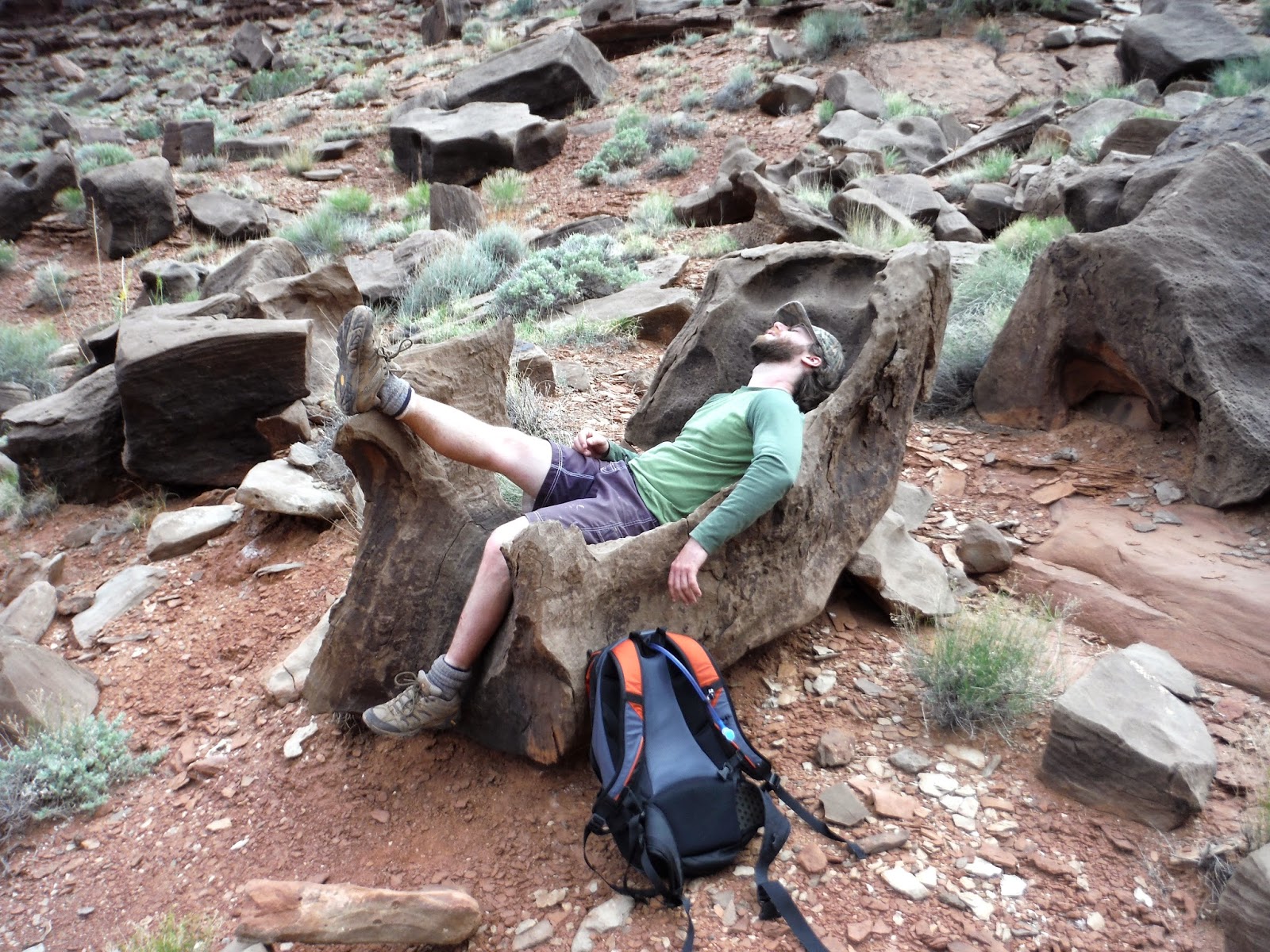
On our way up, we noticed a chair we missed on the way down. It was scrumptiously comfortable. It sucked you into place, and formed perfectly to your body. It was almost a mistake to even sit there in the first place, because the last thing I wanted to do was get back out.

For the sake of Noah's picture, I was able to coax myself out and let him enjoy it for a bit.

Soon, we found ourselves again not on any particular trail, but instead following a moist intermittent stream path. It was clear which gully we needed to ascend, but as per usual, we had differing opinions on how to get there. I was interested in scrambling up the scree field to make my path as straight as possible, and Noah wanted to stick to the trail. We figured it was reasonable to split because we would be able to see each other along the slope anyway. So I scrambled away up the boulders and the cacti, and soon I realized that in the long run, straight up is not much faster because you need to take breaks and drink more water.
After awhile, I was able to see Noah's green shirt move from left to right as he followed the switchbacks. He was moving much quicker than I was at that point, because I had nearly climbed 1000 feet in 4/10ths of a mile at a 70% grade. To be fair, I did ask for it.
Now here's a challenge. Find Noah in the image below. It took me about 5 minutes, and I was there when I took the picture. It just puts some perspective into the massive gully we were ascending.
I had made it to the top of the gully, and I only waited for 8 minutes. I consider this proof that straight up is not the fastest way up, at least on a slope like this. It's effectively the same, because I needed those eight minutes for a break anyway. It was totally worth it though. I love scrambling.

Once clearing the rim (more or less) the wind picked up considerably, and it was blowing us around. It felt amazing to have the breeze though, because it cooled up down from the steep climb we had just done. The worst part was that I was out of both food and water, with still 2 miles to go. Luckily, Noah had some banana bread remaining, which I scarfed down in negligible time. My mind was set on getting to the car and draining my water tank.
For those interested in the mapping process, here is a track that I believe is mostly accurate of our hike. (Note: this is only the descent.)

Trail mileage
Canyon rim: 2.25 mi
White Rim Road: 6.3 mi
Colorado River: 10.1 mi
Total: 20 mi (more or less)
Time
White Rim Road: 3 hours
Colorado River: 5 hours
White Rim again: 7 hours
Trailhead: 9.5 hours
Elevation Range
3900' - 6100'
5.12.15
Refreshed and rejuvenated from a night's sleep, we got up early to drive the few miles into Canyonlands National Park for our hike. Neither of us had been to this park before, so I like to think we were true explorers. This became more and more true as the day went on...

The standard pre-hike photo. I need to note that the mileages posted on this sign (covered up by me) are wrong. I don't even remember what they were, but they disagreed with both my recently purchased NatGeo map of the park, and later with a trace of our path on Google Earth. For anyone thinking they'd like to do this hike, the Canyon Rim is at 2.25 miles, the White Rim Road is at around 5.8, and the Colorado River is at around 10 miles.
The trail began along Gray's Meadow for several miles, and we were both happy to start the day on a relatively flat piece of earth, and because it was still quite early, the sun had not begun its terror on the our blindingly fair skin. There was an odd cabin along the way, and a person exiting the canyon from what appeared to be a several day journey in the canyon.

The meadow gave way to layered rock and sand, and we saw a few water pockets along this section.

Soon, the canyon rim came into view, and we got to see just how vast Canyonlands really is. We were coming in from the northern district of the park, Island in the Sky, which is in between the Colorado and Green Rivers. Hiking east, we were able to see patches of the Colorado among the gorges in the lower canyon, into the Needles District, which is east of the river. (The Maze district is to the west of the rivers, and requires a hellaciously long drive to get to.)

In the zoomed in shot below, the White Rim Road is visible traversing along the lighter rock. I had heard about this road while searching for 4x4 trail to explore in the west, and this one is 100 miles long, and does a loop around the Island in the Sky district. Initially, I wanted to do this road, but permits for camping along it are only available two days prior to arrival, and we had missed that by the time we realized. But the Lathrop trail did go down to meet this road, so that was sufficient for the time being.

The buttes from this side of the canyon were very cool to look at. The furthest left one is called Airport Tower, and though it looks nothing like an airport, we thought maybe they had an air traffic control tower in mind.


The trail had descended the first tier of cliffs, and we were walking along a lower rim of the canyon for several coves or 'lobes' you could call them. We saw a runner up for the famous Old Man of the Mountain that fell from New Hampshire. Meet the Old Man of Canyonlands.

There's nothing like stepping out on a ledge to get a 360° view.

The clouds by this time had formed into a pattern that neither of us had seen before. They looked like cirrus, but with the tiniest ripples in them. This picture also shows the first tier that we had descended and were now following.

A lizard met us on our travels. This was very helpful, since by this point, we had gone too far along the inner rim of the canyon, and were faced with shear cliffs in about every direction we could see. According to the map, it appeared as though we needed to descend in second to last lobe we had hiked to. We were skeptical of this, because again we either had cliffs or steep scree to go down, and we couldn't imagine the NPS making a trail that went along terrain like this. Let me take the time to mention that after the meadow, the trail was only marked by footsteps of other (potentially lost) hikers and occasional cairns that rose at best several inches off the ground.

We asked the lizard for advice on where the trail might be. It was unsuccessful. We resorted to good old fashioned maps. At this time, I was extremely happy to have bought the map for this park. Not that we were lost with no hope of return, but because without it, there would have been no proceeding. We determined our location based on the views of Airport Tower, and I was confident that the trail had to descend in a certain lobe. Noah was (as he should be) skeptical of my claim, thinking we should retrace our steps back one additional lobe of canyon. After scrutinizing at the scree field that lay below us, Noah did find the trail, which was as hidden as you could imagine. Even with rough switchbacks and rock walls, the trail were still nearly invisible until you are right next to it. This made for a fun challenge, especially for me since I am so interested in maps to begin with. After successfully finding the trail again, it was easy to make it down to the lower part of the canyon.
We saw several blocks of fossilized riverbed sediment, with ripples in it just like you might see on some beaches.

Airport Tower (left) and what we coined as the Castle (right) now from a lower perspective. We were beginning to realize that Airport Tower was likely named as such because, like an air traffic control tower, it is quite visible from all viewpoints.

Looking backward along the trail, two amphitheaters of rock became visible. We had descended along the lobe on the right of this photo.

The last part of the trail to the White Rim Road followed a wash for about a mile or so, and soon we found ourselves at the road itself. Time for banana bread if you ask me. Our mileage so far was about 6.4, including our getting lost bit.
 |
| Resting, eating, and hydrating. Lathrop Canyon Road in the background. |
We saw some hard-core bikers making their way up the hill on the road ahead, and only when we began to hike down, did we realize why most of them were pushing their bikes. Though one superhuman managed to stay on the pedals the whole way.
Beware, those with trypophobia - this rock will probably cause premature death for you. If not, feel free to scroll down and see a rock with lots of tiny holes in it. I thought it was cool.

At this point, the ole temperature gauge was reading something around 90°, which made for some slow going even on the mostly flat road down to the river. This portion of the hike descended 500 feet, which made our total descent around 2200 feet.
 |
| The Colorado River! |
We took some time to eat lunch by the river, as well as reapplying copious amounts of sunscreen. At one point, there was a strong gust of wind, which blew a nice coating of sand into our faces, our lunch, and our backpacks. Welcome to Utah.
 |
| Neat, almost animal-like rocky formations. |
 |
| We got some shade on our way back up. Clouds were also increasing, which I was very thankful for. |

Along the Lathrop Canyon Road, we saw a Rover and Jeep headed down to check out the river, and the good news is that we beat them back up to the White Rim Road! As we took another break at the road, we were able to watch one of them climb back up the hill again, engine roaring with the steep grade.
On our way up, we noticed a chair we missed on the way down. It was scrumptiously comfortable. It sucked you into place, and formed perfectly to your body. It was almost a mistake to even sit there in the first place, because the last thing I wanted to do was get back out.

For the sake of Noah's picture, I was able to coax myself out and let him enjoy it for a bit.
Soon, we found ourselves again not on any particular trail, but instead following a moist intermittent stream path. It was clear which gully we needed to ascend, but as per usual, we had differing opinions on how to get there. I was interested in scrambling up the scree field to make my path as straight as possible, and Noah wanted to stick to the trail. We figured it was reasonable to split because we would be able to see each other along the slope anyway. So I scrambled away up the boulders and the cacti, and soon I realized that in the long run, straight up is not much faster because you need to take breaks and drink more water.
After awhile, I was able to see Noah's green shirt move from left to right as he followed the switchbacks. He was moving much quicker than I was at that point, because I had nearly climbed 1000 feet in 4/10ths of a mile at a 70% grade. To be fair, I did ask for it.
Now here's a challenge. Find Noah in the image below. It took me about 5 minutes, and I was there when I took the picture. It just puts some perspective into the massive gully we were ascending.
 |
| Find Noah! |

Once clearing the rim (more or less) the wind picked up considerably, and it was blowing us around. It felt amazing to have the breeze though, because it cooled up down from the steep climb we had just done. The worst part was that I was out of both food and water, with still 2 miles to go. Luckily, Noah had some banana bread remaining, which I scarfed down in negligible time. My mind was set on getting to the car and draining my water tank.
For those interested in the mapping process, here is a track that I believe is mostly accurate of our hike. (Note: this is only the descent.)

Canyon rim: 2.25 mi
White Rim Road: 6.3 mi
Colorado River: 10.1 mi
Total: 20 mi (more or less)
Time
White Rim Road: 3 hours
Colorado River: 5 hours
White Rim again: 7 hours
Trailhead: 9.5 hours
Elevation Range
3900' - 6100'
I cannot find Noah. I cannot find Waldo. Where are they?? I take it those shrubs are trees then? Several specks could therefore be human.
ReplyDelete