Day 27
We got some snowy sun-flurries in the morning after starting to cook some breakfast. And by breakfast, I mean lots of banana bread. And by cook, I mean spread lots of butter on the bread.

You would be hard-pressed to convince me it was May if you showed me this photo below. There was one other car who had passed through right before us. But we effectively had Pando to ourselves overnight.

In Lyman, UT, we discovered the epitome of police laziness. A cop car with a DUMMY inside. (This could be an under-staffing issue, but I think laziness is more likely the case.)

On our way east toward the Moab area, we passed through Capitol Reef NP to check out some huge cottonwood trees. We would have hiked, but Moab was still a good distance off, and we wanted time to hike around in Arches NP.
We drove along some parts of the monocline while passing through the park. There are many walls that resemble those of Zion NP; tall, steep and made of sandstone.
Some kickin' paleosols around this part of the country. (That's what you call this kind of petrified dirt in flumes like this.)

We drove my this marshy area that was very still, and I had to turn around to get a photo of the reflection.

Walking along the rocks to the right, there is a basin that is clearly where water swirled around for years and years to slowly carve out the shape.

Again, the La Sals were luring me in, and I had to capture them in a panorama.

Walking a bit further around the basin, there is a point that you can stand to view the arch from the opposite side. This is rarely photographed (or at least rarely posted onto the internet), so I thought it was more unique to snap it from this angle.

We took opposite sides of the basin on our way back, and Noah got this neat photo of me with the mountains in the background.

I finally went up the the arch itself, and tried to capture it in a different way that people usually see.
After this hike, we moved on to Sand Dune Arch, which is found....you guessed it...amongst lots of sand.
Now for the star of the show - Landscape Arch. This is the one on the brochure they give you when you enter the park. They had better lighting (and blue sky) for that photo. It's amazing how something so heavy as rock can stay when it's so thin as it is in this arch. Three pieces of the arch have fallen since 1991, each measuring 30, 47 and 70 feet long. That's why there's no longer a trail underneath it. Landscape Arch is still the longest arch in the world, spanning 290 feet across.
On our way back to the parking area, the clouds broke a bit near the setting sun, and the rocks became backlit. This piqued my interest because we had had some sprinkles of rain along the hike to Landscape, and since it was sunset, I was hoping for a rainbow.

I got my rainbow. One of the better ones I've seen, at that. Many other park visitors must have thought the same, because it was a battle scene trying to make our way along the road back to town.

We stopped in town to find internet for campsite searching. We were initially going to stay along Rt. 128 at one of the primitive campsites, but everyone beat us there and everything was full. So that meant plan B. I spotted one halfway up the hills in the La Sal Mountains, and that was the deal-breaker for me. We had to go. Thirty miles of winding road from Moab up to Masons Draw CG at 8320 feet. We hit the time of day perfectly to get this awesome alpenglow on the mountains.

It was reminiscent of the days at Baxter, when Katahdin would turn orange and pink in the sunset, sometimes with lenticular clouds around the peak, proving its grandeur over the state.
We passed through snow squalls as Wombat scaled the roads higher and higher. Soon though, it cleared, and we had stunning colors over the valley.

For once, it was only chilly, and not windy when we got to the campsite. There was one other person with a camper, but other than that, we had the mountains to ourselves. I was so happy to be actually there in the mountains after having seen them from a distance all day. We were also surrounded by more aspen groves at this elevation.
Here's our map of the day's route.
Dinner was once again a pseudo turkey dinner, but this time we added ham and mozzarella to our mixture of potatoes, gravy, and chicken. I vote 5 stars. Super easy to cook in the backcountry, and it tastes pretty darn good too.
We had a mostly clear night, which was startling after having snow so far every night on the Trans-Utah Loop. The stars were numerous, since the moon had not yet risen. The moon is one thing we became more aware of as the trip went on. Ever since visiting Lowell Observatory in Flagstaff, the sky has become of interest to both of us. When you're unplugged from society and tenting every night, that's what you notice.
5.10.15
Our night spent among the aspens of Pando was amazing, and guess what? More snow. We should probably be expecting snow if we go and camp above 9000 feet. But it was still a nice surprise, even after listening to Perfect Paul tell us the forecast on our weather receiver. This is one of the joys of camping - you really have to prepare for anything.
 |
| Welcome to Utah. |

You would be hard-pressed to convince me it was May if you showed me this photo below. There was one other car who had passed through right before us. But we effectively had Pando to ourselves overnight.

In Lyman, UT, we discovered the epitome of police laziness. A cop car with a DUMMY inside. (This could be an under-staffing issue, but I think laziness is more likely the case.)

On our way east toward the Moab area, we passed through Capitol Reef NP to check out some huge cottonwood trees. We would have hiked, but Moab was still a good distance off, and we wanted time to hike around in Arches NP.
 |
| Cottonwood, estimated 7 feet in diameter! |
 |
| Do not attempt this kind of shot without adult supervision. (I had Noah around, so I was all good....wait never mind.) |

We drove my this marshy area that was very still, and I had to turn around to get a photo of the reflection.

 |
| Count the layers. Ready, set.....go! |
We followed Rt. 24 though a long desert, and found ourselves on I-70 near Green River, UT. We saw the occasional cow laying near the highway. I would think it'd be pretty awful to be a cow in these parts. You get the entire land to yourself, but it's filled with sand, scrub brush, cacti, and zero water. You need water? You better hoof it 30 miles to a stream or a drain pipe in the nearest town. Then you see some parts of land that are well irrigated and bright green. No cows. What's wrong with these farmers? We debated that this is how you make jerky. You just set cows free in a desert and don't let them drink any water.
I took another road suggestion from Noah, which was Rt. 128 from I-70 down into Moab. It made our trip slightly longer, but it follows the canyon cut by the Colorado River, which has been the epicenter of our travels so far. The architect of the land.
Along Rt. 128, we saw our first view of the La Sal Mountains of Utah. Beautiful and snow covered, they sat waiting patiently for the views to open up so we could get a glimpse.
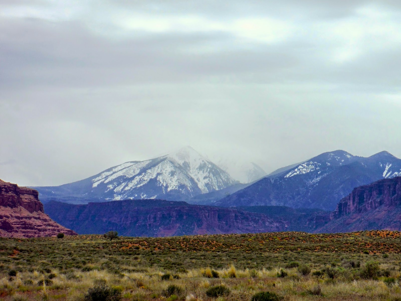 |
| La Sal Mountains |
We successfully made it into Moab, one of the craziest towns I've ever been to. Every other store is adventure related - gear shops, climbing shops, 4x4 dune buggy rentals, kayaking, anything you can imagine, it's there in Moab.
We decided to check out a eatery suggested to me from my friend Kitty from Monroe, and that would be Milt's Stop 'n Eat. Kitty, if you're reading this, I've got to say this place was awesome to visit. It was jam packed, and because of this the burger guys were moving very quickly to try and get everyone's orders out. It was a bit of a wait, but I've never left a place quite so full. And I wanted to go and hike in Arches NP after that? Roll me instead please.
It's a bit cliché, but Delicate Arch was our first stop inside the park, and here is an even more cliché shot of it, with the La Sal Mtns. inside the arch. It was much larger than I had expected. I thought that it was maybe 10 feet tall, but this this towers over the landscape, probably 40 or 50 feet tall.
 |
| Delicate Arch |

Again, the La Sals were luring me in, and I had to capture them in a panorama.

Walking a bit further around the basin, there is a point that you can stand to view the arch from the opposite side. This is rarely photographed (or at least rarely posted onto the internet), so I thought it was more unique to snap it from this angle.
 |
| Noah, majestically watching the arch. |

We took opposite sides of the basin on our way back, and Noah got this neat photo of me with the mountains in the background.

I finally went up the the arch itself, and tried to capture it in a different way that people usually see.
 |
| Delicate Arch from the inside |
 |
| Noah inside Sand Dune Arch |
 |
| Landscape Arch |

I got my rainbow. One of the better ones I've seen, at that. Many other park visitors must have thought the same, because it was a battle scene trying to make our way along the road back to town.

We stopped in town to find internet for campsite searching. We were initially going to stay along Rt. 128 at one of the primitive campsites, but everyone beat us there and everything was full. So that meant plan B. I spotted one halfway up the hills in the La Sal Mountains, and that was the deal-breaker for me. We had to go. Thirty miles of winding road from Moab up to Masons Draw CG at 8320 feet. We hit the time of day perfectly to get this awesome alpenglow on the mountains.

It was reminiscent of the days at Baxter, when Katahdin would turn orange and pink in the sunset, sometimes with lenticular clouds around the peak, proving its grandeur over the state.
We passed through snow squalls as Wombat scaled the roads higher and higher. Soon though, it cleared, and we had stunning colors over the valley.

Here's our map of the day's route.
 |
| Trans-Utah Loop, Day 3: 340 miles |
Dinner was once again a pseudo turkey dinner, but this time we added ham and mozzarella to our mixture of potatoes, gravy, and chicken. I vote 5 stars. Super easy to cook in the backcountry, and it tastes pretty darn good too.
We had a mostly clear night, which was startling after having snow so far every night on the Trans-Utah Loop. The stars were numerous, since the moon had not yet risen. The moon is one thing we became more aware of as the trip went on. Ever since visiting Lowell Observatory in Flagstaff, the sky has become of interest to both of us. When you're unplugged from society and tenting every night, that's what you notice.
Sherry and I have paddled and hiked out in that area 8 or 9 times - a week at a time. One of my favorite places in the world. So glad you're out there - Yeah Nathan!
ReplyDeleteIt has been nice to finally see this area that you and the Davises speak of so much on the Green River trips, among others.
Delete