Confluence Trail
Day 30
5.13.15
We had gone into Moab again after our hike yesterday to find a place to stay that would be near our second hike in the Canyonlands, this time in the Needles District. However, after 20 miles of hiking, we were both tired and hungry, so we decided to head back to Horsethief CG again, where we had stayed the night before. Not exactly close to the next day's trailhead, but we knew it was there. On the way however, we saw a sign for Lone Mesa CG, which appeared to be free, which was better than the not-free Horsethief. After bushwhacking through a maze of RVs, we eventually found a place where we could set up. No picnic table, but a beautiful view. Here's our site the next morning.

I've been having a great time bopping around Utah, but there is one thing I truly despise, and that is the amount of fine sand and dust that gets on everything after awhile. It had been windy the night before, so cooking was moved to the back of the car with the hatch open, but even with that, sand got on every piece of cooking equipment we had with us. Anything that moved now had a nice gritty-scratchy sound to it.
All of that was forgotten by morning when the wind had died down, the sun rose once again, and shed light over the area, and presumably Lose Mesa, which it what I think is in the photo below.

We began our journey out of Island in the Sky, and down toward Needles, which was a surprising distance. It was a lengthy 100 miles just to get to the trailhead for the Confluence Trail. The confluence in question is of course the Colorado and Green Rivers.
Rt. 211 is the way into Needles District, and it is quite the drive. Many buttes and mesas along the way to keep you entertained. Not to mention petroglyphs as well.
We stopped by Newspaper Rock, known for a giant wall of petroglyphs. It's strange how abstract many of them are, for example humans with antlers and the silhouette of a flying squirrel, or a 7-toed foot.


Finally, we made it to the end of the road. Literally the end. It just goes in a loop. The way onward is by foot. So that's what we did. The mileage of the trail ahead of us remained more or less a mystery due to more conflicting information. I tried my best to ignore this fact and just enjoy the trail. It was challenging. Noah can confirm that I was frequently out squinting at the map, trying to figure out how 1.1 miles was equal to 0.7 miles.
In no fewer than three minutes after departure, we had lost the trail. We were faced with a gorge that was supposed to have some switchbacks (maybe?). Using the high calculating powers of our brains, we once again found the trail, marked with microscopic cairns that would make ants frustrated at best. Once past the initial gorge, there is this funny part in the trail where you duck below these rocky outcroppings.
From all we learned working in Baxter State Park, we knew that trail preservation was of utmost concern, especially in high traffic areas such as national parks. Noah did his best to keep the boulders in place.
Crossing meadows of grass and lots of globe mallow, we found yet another view of the La Sal Mountains.
Using simple geometry, we concluded that using the hypotenuse of the camera's dimensions was the most effective way to get the most horizon per megapixel.

Though nothing beats the power of the panorama. Have a look for yourself. La Sal Mtns. to the left, Needles to the right.

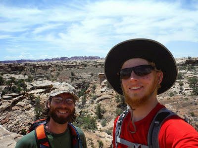
Proof that it was really us doing this hike. I look like I was in a pin-fight because I lost a battle with the Sun on our Humphrey's Peak hike. It's fun regrowing your face every once in awhile right?
The trail joined up with a 4x4 road for a mile or so, then it continued as a hiking path for the last half mile, and it doesn't get much better than this at the end.
The Colorado River is muddier than the Green River. However if you remember from the Grand Canyon pictures, the Colorado is emerald green. This is because of a dam that created Lake Powell in southern Utah. This slows the water down enough for the sediment to sink to the bottom, allowing for the clean water to pass through.

We spent a leisurely hour at the confluence, eating melted sandwiches, the final scraps of out banana bread batch, and a delicious bag of Barbecue kettle chips. These have become a staple of our lives now, hiking or otherwise. I nearly fell asleep on a rock, which would have been fatal due to over-exposure to sunlight. Aside from this potentially bad situation, it was grand lying on a rock and being warmed by the sun.
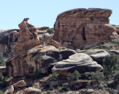
We worked up the motivation to hike back out, mostly because we wanted to make it back into Flagstaff that evening, and that was over 300 miles away. My strange eye for seeing shapes in rocks engaged once again, and we spotted this eagle looking over its shoulder.
We passed several people on our way back to the car, and one group commented that we were going quickly. Noah countered them exquisitely by saying that we were only trying to stay ahead of the bear chasing us. (Something tells me they didn't buy it...)

5.13.15
We had gone into Moab again after our hike yesterday to find a place to stay that would be near our second hike in the Canyonlands, this time in the Needles District. However, after 20 miles of hiking, we were both tired and hungry, so we decided to head back to Horsethief CG again, where we had stayed the night before. Not exactly close to the next day's trailhead, but we knew it was there. On the way however, we saw a sign for Lone Mesa CG, which appeared to be free, which was better than the not-free Horsethief. After bushwhacking through a maze of RVs, we eventually found a place where we could set up. No picnic table, but a beautiful view. Here's our site the next morning.

I've been having a great time bopping around Utah, but there is one thing I truly despise, and that is the amount of fine sand and dust that gets on everything after awhile. It had been windy the night before, so cooking was moved to the back of the car with the hatch open, but even with that, sand got on every piece of cooking equipment we had with us. Anything that moved now had a nice gritty-scratchy sound to it.
All of that was forgotten by morning when the wind had died down, the sun rose once again, and shed light over the area, and presumably Lose Mesa, which it what I think is in the photo below.

Rt. 211 is the way into Needles District, and it is quite the drive. Many buttes and mesas along the way to keep you entertained. Not to mention petroglyphs as well.
 |
| Rt. 211 into Needles District. |


Finally, we made it to the end of the road. Literally the end. It just goes in a loop. The way onward is by foot. So that's what we did. The mileage of the trail ahead of us remained more or less a mystery due to more conflicting information. I tried my best to ignore this fact and just enjoy the trail. It was challenging. Noah can confirm that I was frequently out squinting at the map, trying to figure out how 1.1 miles was equal to 0.7 miles.
In no fewer than three minutes after departure, we had lost the trail. We were faced with a gorge that was supposed to have some switchbacks (maybe?). Using the high calculating powers of our brains, we once again found the trail, marked with microscopic cairns that would make ants frustrated at best. Once past the initial gorge, there is this funny part in the trail where you duck below these rocky outcroppings.
 |
| Duck duck goose. |
 |
| Trail work in progress |
 |
| La Sal Mountains |

Though nothing beats the power of the panorama. Have a look for yourself. La Sal Mtns. to the left, Needles to the right.

Proof that it was really us doing this hike. I look like I was in a pin-fight because I lost a battle with the Sun on our Humphrey's Peak hike. It's fun regrowing your face every once in awhile right?

 |
| Windswept sandstone lined parts of the trail. |
 |
| Colorado River! (Green River going behind the canyon to the back left) |

 |
| The ultimate Colorado River fan! |
We worked up the motivation to hike back out, mostly because we wanted to make it back into Flagstaff that evening, and that was over 300 miles away. My strange eye for seeing shapes in rocks engaged once again, and we spotted this eagle looking over its shoulder.

We passed several people on our way back to the car, and one group commented that we were going quickly. Noah countered them exquisitely by saying that we were only trying to stay ahead of the bear chasing us. (Something tells me they didn't buy it...)

As we neared the end of the trail we saw what we had missed on the way out. Five pillars of rock lined the horizon. Rocks be funny hereabouts, eh.
If you take a rough average of the different trail lengths that were provided to us, you get something around 10 miles roundtrip. It was a memorable way to end our trip, by visiting the point where two great rivers that carved out this park and many more miles in each direction meet.
We celebrated with hot beverages - just the thing you want on a hot day in the desert. Noah brewed himself some coffee with his new space-age device, and I had some uncomfortably sun-baed root beer. When you forget to put it in the cooler, the sun does tend to make liquids hot. I think it was probably the worst root beer I've ever had, but that didn't stop me.
We began the trek southward to Arizona! 330 miles remaining. We got to see the La Sal Mountains fade away, but in their place appeared more mountains. Also, bright green fields, which I was shocked to see in such a dry place. You'd think the cows would be all over it. Zero cows. In fact, I think what they raise out here in the west are highly evolved camels with short necks, not cows. Because the cows I know about need water and grass to grow.
We rolled through miles and miles of desert road, with buttes and mesas in every direction. Soon the sky became darker, but it was so expansive that it took awhile for true darkness to set in. What came first though, was an inability to see through the thick coating of bugs that had decorated my windshield. An emergency glass-cleaning stop was made.
Around 9:30, AZ time, which would be 10:30 UT time since Arizona doesn't observe DST, we happily rolled into Flagstaff. Six days in the backcountry, exploring what Utah has to offer. Fifty miles hiking, 1500 miles driven, and many delicious meals prepared from the mere back of a wagon. It doesn't get much better than that.
To conclude the Trans-Utah Loop posts, I present the complete map of the 6 days we spent traveling.
 |
| Trans-Utah Loop |
PS: Wombat crossed over 170000 miles near Bluff, UT. Congrats for making it 6025 miles along the trip so far! We've got a lot left to make it back to Maine, but great it shall be.
Sand: the new reason to floss.
ReplyDelete